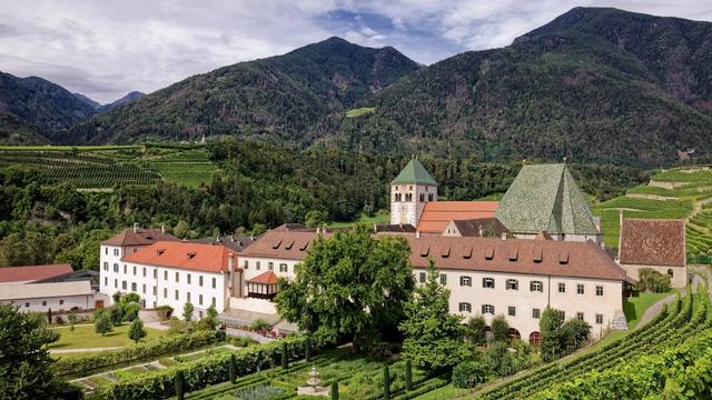
GEOPARC Bletterbach is a gorge in the Dolomites of South Tyrol, near Aldino. Water has cut down through the rock, and the walls now expose the layered sequence that earned this site its place in the Dolomites UNESCO World Heritage listing. Marked routes lead from the visitor centre into the gorge, with a red route through the Butterloch and a higher mountain route above it; a small museum at the entrance explains the layers and the fossils found in them. The walking is on rock and steps, down into the gorge and back up the same way.
GEOPARC Bletterbach - Dolomites UNESCO World Heritage

A helmet comes with the ticket — this is a hike you walk in a hard hat.
- Entrance
- €9 as of summer 2026, covering the park, the small museum, helmet hire and parking. Children under 12 free. Cards and contactless accepted.
- Accessibility
- Accessible parking spaces at the entrance. The gorge route itself is rock and steps and is not wheelchair accessible.
- Parking
- Car park 55 m from the entrance, with a second one 753 m away. The parking charge is covered by the admission ticket. Accessible spaces available.
- Difficulty
- A gorge walk on bare rock and steps, down into the streambed and back up the same way. Hiking boots needed, poles useful, average fitness or better. Marked routes, including the red Butterloch route.
- Transport
- Bus stop Geoparc Bletterbach at the entrance (17 m); the Esperbichl stop is 764 m away.
- Hours
- Open daily 9:30–18:00.
What makes it special
The walk starts at the rim and goes down, and the walls close in as it drops: bands of red sandstone, pale dolomite and dark volcanic rock stacked one above the other, which is what put this stretch of the Bletterbach inside the Dolomites UNESCO World Heritage site. The marked routes split below. The red one, the Butterloch, follows the streambed to the point where the gorge narrows and the waterfall comes down the rock. In settled weather the higher mountain route is open as well, and the two can be walked together. This is a hike rather than a viewpoint: rock underfoot, steps most of the way down, and the same steps to climb at the end, when legs are already tired. Families do it all the same, and a small museum at the entrance lays out the rock sequence before anyone sets off.
Good to know
- Footwear. Hiking boots with grip. The route runs over bare rock and it is uneven the whole way; poles help on the descent.
- Steps. The gorge is walked down and back up the same way, so the climb comes at the end, when legs are already tired.
- After rain. The valley route through the gorge can be closed for safety once it has rained. Ring the visitor centre before driving up.
- Fitness. Skip it without at least average fitness — there is no shortcut back out once you are down in the streambed.
- Dogs and payment. Dogs are allowed on site, and cards are accepted at the ticket desk.
Getting there
Almost everyone arrives by car. The main car park sits at the entrance building, and a second one lies roughly 750 m back down the road. There is also a bus stop at the site itself, so arriving without a car is possible. From the ticket desk the walking begins straight away: the marked route drops into the gorge on steps and comes back up the same way, so the return leg is the climb.
Best time to visit
Better: a dry spell, when the valley route through the gorge and the higher mountain route are both open and can be linked into one walk.
Avoid: the day after heavy rain, when the valley route can be shut for safety and the drive up is wasted — a phone call to the visitor centre settles it in a minute.
Down in the gorge the light is indirect, thrown back off the walls rather than falling straight in; the open views belong to the mountain route higher up.
Sun & daylight
Nearby Places


Similar Places

GEOPARC Bletterbach - Dolomites UNESCO World Heritage on the map
After rain the valley route through the gorge can be closed for safety. Call the visitor centre before you drive up, and turn back if the route is shut rather than walking it anyway. Underfoot it is rock and steps throughout, and wet rock is slippery.
Get directions
Your whole travel map in one place
Get inspired by new places around the world and find the ones worth the journey
Frequently asked questions
Is the Bletterbach walk suitable for children?
Families walk it, and children under 12 go free. It is still a proper hike over rock, with a lot of steps down and the same climb back — children of six and nine have managed the red Butterloch route.What should I wear on my feet?
Hiking shoes with grip. The route runs over bare rock in the streambed. Poles make both the descent and the climb back easier.Can the gorge be closed?
Yes. After rain the valley route is liable to close for safety reasons. Phone the visitor centre before setting out to confirm it is open.Are dogs allowed?
Yes, dogs are allowed on the site.Is there a museum as well as the gorge?
Yes, a small geology museum at the entrance, covered by the same ticket. It sets out the rock layers and fossils you then see in the gorge walls.