La Atalayita is an archaeological site in the Pozo Negro valley, in the municipality of Antigua on Fuerteventura. The Majos, the island's pre-Hispanic people, lived here before the European conquest of the 15th century. The site holds 115 structures: semi-sunken round houses known as casas hondas, larger houses of several linked rooms, and a natural cave adapted as a dwelling. It was declared a Bien de Interés Cultural in 2007, and an interpretation centre stands on site.
La Atalayita Archaeological Site
Local name: Poblado de La Atalayita
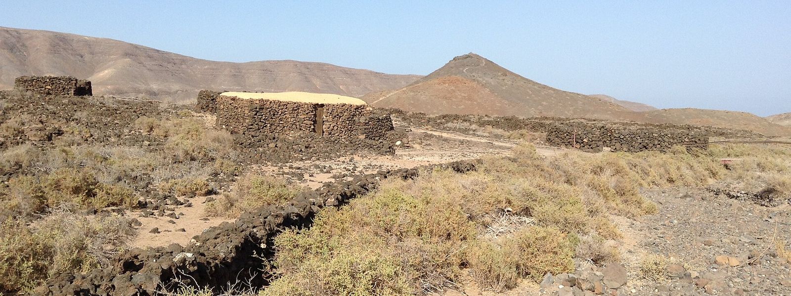
Pre-conquest Majo village of 115 stone structures, half-sunken houses set into a lava field in the Pozo Negro valley.
- Entrance
- Free entry.
- Accessibility
- The approach is by an unmade track, the ground across the site is uneven lava, and the semi-sunken houses have low doorways and ceilings.
- Parking
- Car park for the site, about 138 m away in a straight line.
- Difficulty
- Easy. The car park is about 138 m from the site in a straight line, the walk crosses uneven lava, and the optional climb up the small hill at the back is easy.
- Transport
- No bus stop near the site; a car is needed.
- Hours
- Interpretation centre: Tuesday–Saturday 10:00–14:00; closed Sunday and Monday. The ruins can be walked self-guided when the centre is closed.
- Address
- Antigua, 35629, Las Palmas, Spain
What makes it special
The houses sit low in the lava, half below ground, walled in dry stone built from the same black rock that surrounds them. Duck into one of the round casas hondas and the ceiling closes in overhead, vaulted with volcanic stone from the flows of the Caldera de La Laguna and the Caldera de Liria. There are 115 structures in all, among them larger houses of several linked rooms and a natural cave fitted out as a home.
Climb the small hill at the back. Only from the top does the size of the settlement come clear, spread across the lava field. One house has been restored with a roof of tamarisk branches and mud, built the island's traditional way. After the conquest, shepherds put some of the structures to use for their flocks on what was communal grazing land. The interpretation centre has displays in English and Spanish, among them a goat-ear display.
Good to know
- There are no facilities: no toilets and no drinking water at the site or nearby. Bring water with you.
- Outside the interpretation centre's hours the ruins can still be walked self-guided, but without the displays and staff that explain them.
- The sunken houses have low doorways and low ceilings. Watch your head going in.
- The lava field is bare and has no shade. Bring a hat and sun cream.
Getting there
La Atalayita lies in a remote stretch of the Pozo Negro valley. The last part of the drive is an unmade track leaving a minor road that runs down to the coast, and the way in is fairly well signposted. The site's own car park sits about 138 m away in a straight line; from there you walk across the lava to the houses and the interpretation centre. There is no bus stop near the site, so plan on coming by car.
Best time to visit
Best: a Tuesday-to-Saturday morning, when the interpretation centre is open and staff are on hand.
Avoid: the middle of a hot day, and Sundays and Mondays if you want the displays.
The lava field is bare with no shade, and the centre only opens in the morning; on closed days the ruins can be walked on your own, with nobody there to explain them.
Sun & daylight
Nearby Places
Similar Places
La Atalayita Archaeological Site on the map
The lava underfoot is sharp and uneven, and the sunken houses have low ceilings and doorways. Wear closed shoes and keep your head down going in.
Get directions
Your whole travel map in one place
Get inspired by new places around the world and find the ones worth the journey
Frequently asked questions
Can you visit La Atalayita when the interpretation centre is closed?
Yes. The ruins can be walked self-guided when the centre is shut, with no staff on hand to explain them. There are no facilities at the site on any day.Where is the best view of the whole settlement?
From the small hill at the back of the site. It is an easy climb, and from the top the whole spread of houses across the lava field is in view.Who lived at La Atalayita?
The Majos, Fuerteventura's pre-Hispanic people, lived here before the European conquest of the 15th century. After the conquest, shepherds used some of the structures for their livestock.Why is it called La Atalayita?
Sebastián Jiménez Sánchez, who first studied the site in the 1950s and 1960s, called it El Saladillo. The name La Atalayita came into use with Demetrio Castro Alfín's work here between 1974 and 1977.Are there toilets or drinking water?
No. There are no toilets and no drinking water at the site or nearby, so bring water with you.