La Entallada Lighthouse is an active lighthouse on the east coast of Fuerteventura, near the village of Las Playitas in Tuineje. Completed in 1955 to a design by the architect Carlos Alcon, it draws on Moorish architecture: coloured stone from Tetir set in whitewashed mortar, and three square towers facing the sea. It stands on high cliffs with its light 196 m above the sea, the third-highest in the Canaries, and the headland is regarded as the closest point in the islands to Africa, 100 km east.
La Entallada Lighthouse
Local name: Faro de La Entallada
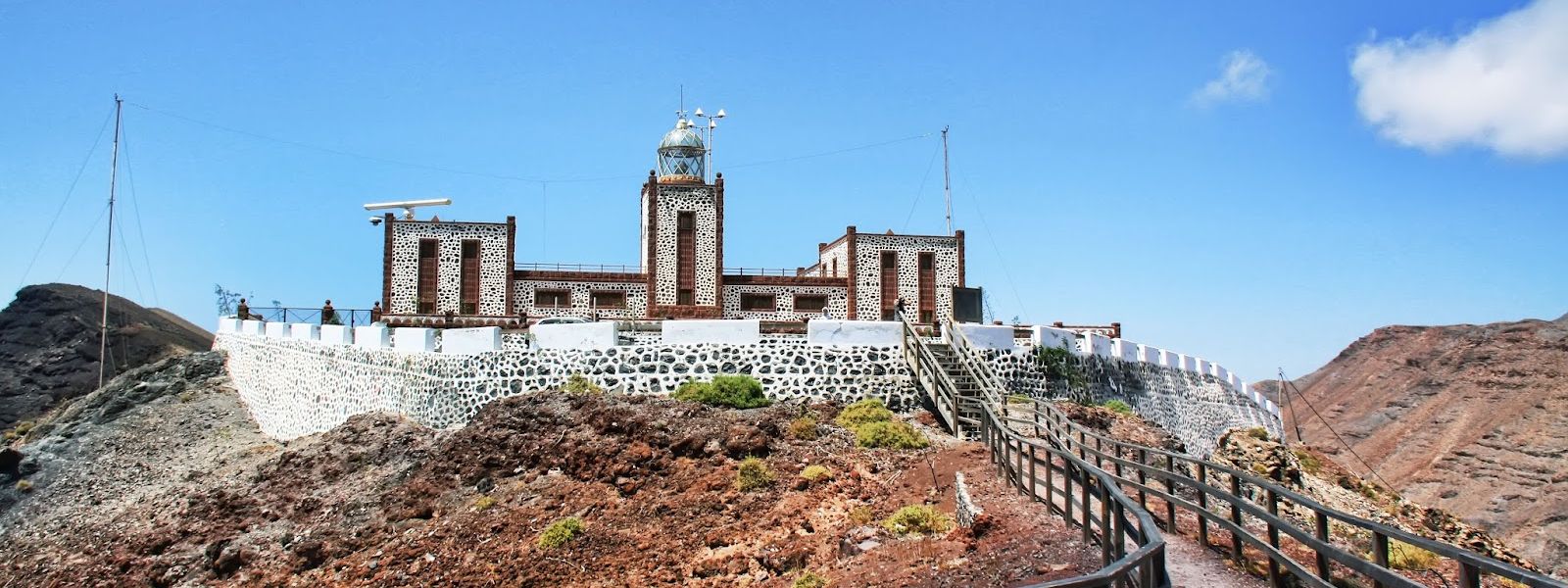
Moorish-style 1955 lighthouse of contrasting stone on high cliffs, its light 196 m above the sea.
- Entrance
- Free to walk the grounds and the viewpoint.
- Accessibility
- Wheelchair-accessible parking and entrance; the car park sits right beside the building.
- Parking
- Free asphalt car park beside the lighthouse, about 30 m away, with wheelchair-accessible spaces.
- Difficulty
- Park beside the lighthouse and walk straight in; the effort is in the drive up, a narrow cliff road with no guardrails. On foot from lower down, the climb takes about 20 minutes.
- Transport
- No bus reaches the lighthouse; the nearest stops are about 3.5 km away in a straight line.
- Advance booking
- Not needed for the grounds and viewpoint.
- Hours
- Tuesday–Saturday 10:00–16:00; closed Sunday and Monday. The display inside is not always open.
- Address
- 35629, Las Palmas, Spain
What makes it special
Three square towers of coloured stone, picked out in white mortar, face the sea from the top of the cliff, and the tallest carries a lantern dome made entirely of glass. Round the back, two wings close around a courtyard with an arched walkway on three sides, like a cloister. The architect Carlos Alcon built it in 1955 with Moorish architecture in mind, using stone brought from Tetir in the centre of the island.
Then there is the height. The light sits 196 m above the sea, the third-highest in the Canaries, and its three white flashes every eighteen seconds reach 21 nautical miles out. From the viewing platform the coast falls away below and the Atlantic runs east towards Africa, 100 km off. In the past it guided aircraft as well as ships: planes from Gando were steered by it towards the Spanish Sahara, including during the Ifni conflict.
Good to know
- The road: paved, with no guardrails, sheer drops and blind bends; near the top, check nobody is coming down before you commit.
- Large vehicles: camper vans and bigger vehicles should not attempt the road up.
- Inside: the display is not always open; walking the grounds and the viewpoint costs nothing.
- Wind: strong on the clifftop, so bring a layer and keep a grip on hats and phones at the platform.
- Facilities: toilets beside the car park; no drinking water nearby, so bring your own.
Getting there
The lighthouse stands on the headland near Las Playitas, and the last stretch is a paved road climbing the cliffs to a free car park right beside the building. The road has no guardrails, the bends hide oncoming traffic, and in places it is barely wide enough for one vehicle. Drive slowly, and on the approach to the lighthouse hold back to check nobody is coming down; do the same as you leave. Camper vans and larger vehicles should not take it on.
If you would rather not drive the top section, leave the car lower down and walk up: about 20 minutes on foot. No bus comes up here, and the nearest stops are about 3.5 km away in a straight line.
Best time to visit
Best: a clear morning, on a day the display is open. The coast faces east, so the morning sun comes in off the sea and falls full on the three seaward towers.
Avoid: driving up at dusk or after dark. With no guardrails, sheer drops and blind bends, the road wants full daylight.
Sun & daylight
Nearby Places
Similar Places
La Entallada Lighthouse on the map
The road up has no guardrails, sheer drops and blind bends, so drive slowly and give way near the top. On the clifftop the wind is strong: keep well back from the edge and keep children close.
Get directions
Your whole travel map in one place
Get inspired by new places around the world and find the ones worth the journey
Frequently asked questions
Does it cost anything to visit La Entallada Lighthouse?
Walking the grounds and the viewpoint is free, and there are toilets beside the car park. The display inside is not always open, but the views are there either way.Is the road up to the lighthouse difficult?
It is paved, but it has no guardrails, sheer drops and bends that hide oncoming traffic, and in places there is room for one vehicle only. Drive slowly, check for cars coming down near the top, and leave camper vans and larger vehicles below. Walking up from lower down takes about 20 minutes.Is La Entallada really the closest point in the Canaries to Africa?
The lighthouse is regarded as the closest point in the Canary Islands to Africa, which lies 100 km to the east.Can you get to the lighthouse by bus?
No bus comes up to the lighthouse. The nearest stops are about 3.5 km away in a straight line, so a car is the practical way up.