Los Encantados Ravine is a barranco, a seasonal watercourse, in the municipality of La Oliva in the north of Fuerteventura. Its walls of pale, soft rock have been worked by wind and water into folds, hollows and ribbed curves, and the canyon runs long enough that seeing most of it takes at least an hour. It lies in open, empty country, approached from El Cotillo. Parts of the rock have been damaged by vandalism.
Los Encantados Ravine
Local name: Barranco de los Encantados
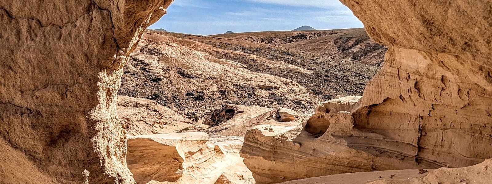
Long ravine of wind-sculpted pale rock in the north of Fuerteventura, reached along a bumpy, rock-strewn track.
- Entrance
- Free; the ravine is open ground with no ticket.
- Accessibility
- Not suited to wheelchairs or limited mobility: the approach is a rocky, bumpy track and the ravine floor is rough and unpaved.
- Parking
- No mapped car park at the ravine. The nearest are about 3.3 km away in a straight line, and Playa de Esquinzo Parking about 3.5 km away.
- Difficulty
- Walking in the ravine is easy over unpaved ground; allow at least an hour. Hiking in from El Cotillo is a demanding trek of several hours in full sun on paths that are not always marked.
- Transport
- The nearest bus stop is about 4.8 km away in a straight line; a car is the practical way in.
- Advance booking
- No booking needed.
- Hours
- Open at any time; daylight hours are the practical limit.
- Address
- Barranco Encantado, 35649, Las Palmas, Spain
What makes it special
The rock looks poured. Walls of pale stone bend and fold into ribs, scoops and hollows, soft enough that the wind has shaped them the way a thumb shapes clay, and every turn of the canyon opens another set of curves.
The ravine is long. An hour covers most of it, and two and a half hours of wandering still leaves more to explore. Out here the quiet is part of the draw: open country on every side and nothing between you and the rock.
Low sun brings out the colour in the stone, which is one more reason to come late in the day.
The softness that makes the shapes also makes them easy to damage, and parts of the walls are scarred by vandalism. Much of the canyon is still intact.
Good to know
- No toilets and no drinking water at the ravine or nearby; bring plenty of water and sun protection.
- Mobile signal is missing across much of the area, so download an offline map before setting out.
- Navigation apps can pick strange routes here; check your directions before you leave.
- Heat reflects off the rock walls in the afternoon, so plan the walk for early or late in the day.
- The soft rock is easily damaged and parts are already scarred by vandals; touch nothing and leave no mark.
Getting there
Most visitors drive. Come in from the El Cotillo side: the other road is very narrow, and meeting a car coming the other way there is a real problem. The track is strewn with rocks and bumpy, so take it slowly; the driving itself is easy enough at that pace. Navigation apps can send you on odd routes, so settle the way before you set off. The nearest mapped car parks are about 3.3 km away in a straight line.
The ravine can also be reached on foot from El Cotillo. That is a long, demanding hike of several hours across open ground in full sun, on paths that are not always marked and with no mobile signal for most of the way. Download the route and map before you leave, carry plenty of water and start early.
Best time to visit
Best: late afternoon running into sunset; for the hike from El Cotillo, a start just before sunrise.
Avoid: midday and the early afternoon, especially in the summer months.
The pale rock throws the afternoon heat back at you, while low sun at either end of the day keeps temperatures manageable and puts soft light on the stone.
Sun & daylight
Nearby Places
Similar Places
Los Encantados Ravine on the map
The ravine is open to the sun and heat reflects off the rock walls; carry plenty of water and sun protection. The soft rock crumbles at edges and overhangs, so keep back from the rims and do not climb the walls.
Get directions
Your whole travel map in one place
Get inspired by new places around the world and find the ones worth the journey
Frequently asked questions
How long does a visit to Los Encantados Ravine take?
Allow at least an hour to see most of the canyon. Two and a half hours of walking around still leaves more to explore.Which way should I drive in?
Approach from the El Cotillo side. The other road is very narrow and difficult if a car comes the other way. The track is rocky and bumpy, so drive slowly, and check your directions in advance because navigation apps can choose odd routes.Can I hike to the ravine from El Cotillo?
Yes, though it is a demanding trek of several hours under the sun. Paths are not always marked and there is no mobile signal for most of the way, so download a map beforehand, start before sunrise and bring plenty of water and sun protection.Are there toilets or water at the ravine?
No. There are no toilets and no drinking water at the ravine or nearby, so bring everything you need.When is the best time of day to go?
Late afternoon towards sunset. It avoids the worst of the afternoon heat reflecting off the rock, and the low light suits the pale stone.