Levada Fajã do Rodrigues, also known as Levada Fajã da Ama, is a classified walking trail (PR 16) in the municipality of São Vicente on Madeira. It follows the walkway beside an irrigation channel from Ginjas to Ribeira do Inferno, the watercourse that feeds it, and returns the same way, staying between 600 m and 630 m in altitude. The route is known for its waterfalls, its views over the São Vicente valley and its unlit tunnels, the last of them about a kilometre long.
Levada Fajã do Rodrigues (PR 16)
Local name: PR 16 - Levada Fajã do Rodrigues
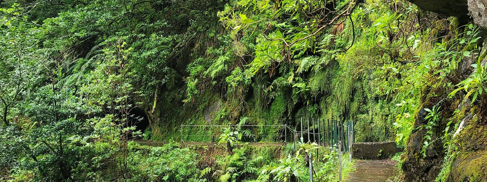
Nearly level levada walk above São Vicente, with waterfalls and a kilometre-long unlit tunnel before a steep gorge.
Levada Fajã do Rodrigues (PR 16) on the map
- Route length
- 3.8 km · one way
- Entrance
- €4.50 for visitors over 12; free for children 12 and under, Madeira residents and people with a disability of 60% or more.
- Walking time
- 3 to 3.5 hours there and back; the last tunnel alone takes 15 to 30 minutes each way.
- Difficulty
- Moderate. Almost no ascent, but wet ledges, unfenced cliff drops and low, unlit tunnels with a narrow walkway; steep pull up from the car park.
- Parking
- Free car parks about 150 m and 290 m away, plus free street parking; the last 200 m to the start is a steep hill.
- Transport
- Ginjas bus stop, about 600 m away in a straight line.
- Accessibility
- No wheelchair or pushchair access: a steep hill to the start, then ledges and tunnel walkways as narrow as 15 cm.
- Advance booking
- Compulsory for everyone, exempt walkers included: a timed entry slot on the SIMplifica Portal, same day if places remain.
- Address
- Caminho Velho das Ginjas, São Vicente, Portugal
What makes it special
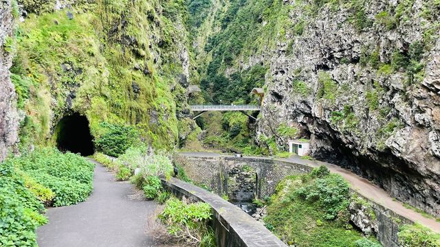
The last tunnel runs for about a kilometre in total darkness. You stoop along a slick concrete rim in single file, the water channel at your feet and the roof dripping, for 15 to 30 minutes. Then the walls open onto the gorge of Ribeira do Inferno, deep, steep and thick with green, where the levada takes its water.
Everything before it is gentle going. The path barely changes height, while waterfalls come close enough to soak you and fish move in the channel. Exotic forest leads into dense Laurissilva, and at some points the view opens across the São Vicente valley. The start is busy, but after the first couple of waterfalls only a few walkers remain.
The route
From the car park, a steep hill of around 30% climbs 200 m to the start of the trail at Ginjas. It is the only real climb of the day.
At Ginjas the path joins the levada's walkway and stays almost level, through exotic forest that leads into dense Laurissilva. The first waterfalls come along this stretch, close enough to soak you.
Past them, the path follows a steep cliff with no handrail in places and crosses a slippery rocky slope. At some points the view opens across the São Vicente valley.
In the first two tunnels the walkway either side of the water is 15 to 30 cm wide, a boot's length at best. The second is roughly halfway, and you can turn back there.
Further on, a waterfall stands in front of the last tunnel: about a kilometre, unlit and single file. It comes out in the gorge of Ribeira do Inferno, where the trail ends. Return the same way, tunnel included.
Good to know
- Light: the tunnels have no lighting. Bring a headlamp, which keeps both hands free, and a charged phone as backup.
- Getting wet: waterfalls can soak you and the tunnels drip, so pack a rain shell or poncho. Most of the path is shaded and cool.
- Headroom: tunnel roofs are low and the walkway is narrow, so tall or broad walkers move slowly and may struggle.
- Supplies: no toilets or drinking water at the start, and none nearby. Fill up before you come.
- Status: check the IFCN trails page before you book; it shows whether each PR is open or closed.
Getting there
Ginjas sits above São Vicente. Two free car parks lie about 150 m and 290 m away, with free street parking as well; expect dirt and grass underfoot. Whichever you use, the last 200 m to the start climb a steep hill, so leave time for it before your entry slot.
The nearest bus stop is Ginjas, about 600 m away in a straight line. Check the return times against a walk of 3 to 3.5 hours before you book.
The trail ends at Ribeira do Inferno and comes back the same way, so you finish where you started and need no second car or transfer.
Best time to visit
Best: the first hour of the morning, above all if you mean to walk the last tunnel. It is single file, and the crossing goes quickest with nobody blocking the path.
Avoid: heavy rain and the time just after it. The rock is already slippery, the waterfalls run harder, and the ravine walls can shed stones.
Most of the path is shaded and cool, so a hot day suits it. Rain does not earn a refund, so look at the forecast before you pay.
Access & restrictions
Levada Fajã do Rodrigues is a classified walking trail managed by IFCN, and entry runs on timed slots booked only online through the SIMplifica Portal; bookings and fees are not handled at IFCN premises. Everyone registers, including those who walk free. A slot closes automatically once it is full, and the tolerance for entering outside your slot is around 15 minutes.
Madeira residents walk free on showing their resident card and citizen card. Children aged 12 or under are exempt, as are people with a disability of 60% or more, with documentary proof, and one legal guardian accompanying each of them.
A paid booking is moved or refunded only when the authorities or IFCN officially close or restrict the trail on that date. Rain, a wrong date or a change of plan loses the money. Booking several trails applies the cheapest daily or multi-day rate automatically, and each trail still needs its own booking.
Things to do nearby
All tours in São Vicente on GetYourGuide
Paid links: booking through them supports YowJourney.
Sun & daylight
Along the route
Similar Places

Levada Fajã do Rodrigues (PR 16) on the map
The path follows steep cliffs with no handrail in places, over wet, slippery rock, and the unlit tunnels leave only a narrow rim beside the water channel. Wear a headlamp, watch every step, and stay away in heavy rain, when the ravine walls can shed rock.
Get directions
Your whole travel map in one place
Get inspired by new places around the world and find the ones worth the journey
Frequently asked questions
Do I have to book this walk in advance?
Yes. Everyone needs a timed entry slot on the SIMplifica Portal, including children and others who walk free. Same-day booking works if the slot still has places.Is a phone torch enough for the tunnels?
Bring a headlamp. The tunnels have no light, the walkway is narrow and slick, and you will want both hands free. Keep a charged phone as backup.Can I skip the long tunnel?
Yes. Turn back at the waterfall in front of it and return the way you came. You still get the earlier waterfalls and tunnels, but you miss the gorge of Ribeira do Inferno at the end.How hard is the walk?
The official grade is moderate. The path is almost level, but it runs along steep cliffs with no handrail in places, stays wet and slippery, and the tunnels are low and narrow. The 200 m from the car park to the start is the only steep climb.How long does it take?
Allow 3 to 3.5 hours there and back over 7.8 km. You return along the same path, last tunnel included, and the crossing takes 15 to 30 minutes each time.