São Lourenço Point is the PR 8 walking trail, officially Vereda da Ponta de São Lourenço, on the peninsula that forms the easternmost point of Madeira. It runs from Baía d'Abra to Casa do Sardinha through a nature reserve established in 1982. The peninsula is volcanic, mostly basalt with some limestone sediment, and its semi-arid climate and northern winds leave low vegetation and no trees. It is known for its coastal views, rare plants and seabird colonies.
São Lourenço Point (PR 8)
Local name: Ponta de São Lourenço

Treeless there-and-back trail along Madeira's volcanic eastern tip, with the ocean on both sides.
São Lourenço Point (PR 8) on the map
- Entrance
- €4.50 for visitors over 12; those aged 12 or under walk free, as do Madeira residents and some others.
- Walking time
- 2 hours 30 minutes to 4 hours, there and back.
- Difficulty
- Moderate. Undulating path between 23 m and 126 m, exposed to strong wind, beside eroded cliff edges, and muddy in rain.
- Parking
- Free car parks near the start, some paid parking too; they fill up, and you may have to park further back.
- Transport
- Baía d'Abra stop, by the start of the trail.
- Accessibility
- No wheelchair-accessible entrance; the path rises and falls over rock, with muddy sections in rain.
- Advance booking
- Compulsory timed slot on the SIMplifica portal, exempt walkers too; book days to a week ahead.
What makes it special
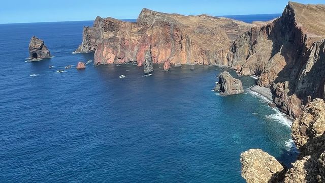
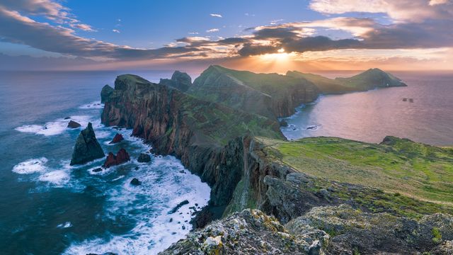
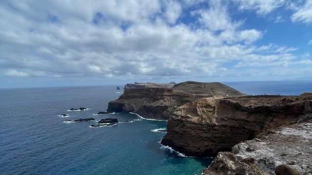
Nothing else on Madeira looks like this. The green of the island stops, and the peninsula runs out into the Atlantic as bare rock and dry, sandy ground, with the ocean to the north and the south of you at once and no tree anywhere to block it. It feels like stepping onto a different island.
Viewpoints line the route, and the last one, at the top of the final climb, is the best. Beyond the tip lie two islets: Desembarcadouro Islet (Ilhéu do Desembarcadouro) and Farol Islet (Ilhéu do Farol), with its lighthouse.
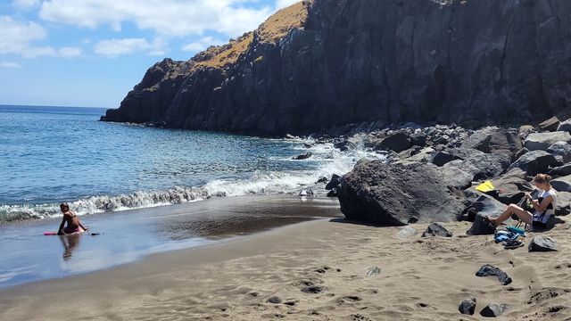
Keep an eye on the air and the water too. Madeira's largest Caspian gull colony nests here, along with protected shearwaters and Bulwer's petrels, and with luck a monk seal shows in the sea below. The walk finishes with a swim at Cais do Sardinha.
The route
At Baía d'Abra a guidepost and an information board mark the start, and your booking is checked here. The path is well marked from this point on. Where a temporary diversion moves it, signs and arrows show the way, and you follow them.
Along the peninsula the path rises and falls between 23 m and 126 m over rock and sandy ground, with viewpoints over the north and south coasts. Parts of the coast beside it are heavily eroded, so stay on the marked line.
Near the end a stop sells drinks and snacks before the last climb, and the top of that climb is the final viewpoint.
At the far end the official route finishes at Casa do Sardinha, and Cais do Sardinha is the place to swim. From there you walk back the way you came, another 4 km.
Good to know
- No shade: there are no trees on the peninsula, so expect full sun all the way and bring a hat that stays on in the wind.
- Water: none to drink near the start, so fill up beforehand. A stop before the last climb sells drinks and snacks; carry your own anyway.
- Footwear: wear shoes with grippy soles, hiking shoes for preference. Rain turns sections of the path to mud.
- Toilets: paid ones by the start, free ones about 780 m away in a straight line.
- Bookings: a missed or changed slot loses the fee, rain included. Refunds and changes apply only when the trail is officially closed or restricted.
Getting there
The walk starts at Baía d'Abra, in Caniçal at the eastern end of Madeira, and you reach it by car or by bus. A stop named after the bay stands close to the start; a second, Caniçal/Praínha/Baía d'Abra, is about 880 m away in a straight line.
For drivers, parking is the awkward part. Spaces near the start are hard to get: a few minutes' wait can free one, or you can end up parking far back and walking in. Allow for that when you choose a slot, because the entry time leaves little leeway.
The path comes back to where it began, so you leave the way you arrived.
Best time to visit
Best: a dry day, as early or as late as the slots allow. The hours around midday are the hottest on a path with no shade, and late in the day the sun sits behind you on the way out and lights the rock ahead.
Avoid: rain, strong wind and the middle of a summer day. Rain turns sections of the path to mud, gusts throw walkers off balance near the cliff edges, and the summer sun has nothing to stop it.
A lot of people walk this trail, but the slots and the length of the path spread them out, so it does not feel crowded.
Access & restrictions
São Lourenço Point is a Partial Nature Reserve on a classified trail run by IFCN, and entry is by booked slot only. Every walker registers on the SIMplifica portal, including those who pay nothing; IFCN offices take no bookings or payments. The slot you pick is your entry time, with a tolerance of around 15 minutes, and a slot closes once it is full.
Walking free: anyone aged 12 or under, residents of the Autonomous Region of Madeira with a resident card and citizen card, and people with a disability of 60% or more plus one accompanying legal guardian, with documentary proof.
If you book several trails, the portal applies the cheapest combined rate by itself, and each trail still needs its own slot.
Where signs and arrows mark a temporary diversion, you must follow them. Whether the trail is open is posted on IFCN's official trails page.
Things to do nearby
All tours in Machico on GetYourGuide
Paid links: booking through them supports YowJourney.
Sun & daylight
Along the route
Similar Places
São Lourenço Point (PR 8) on the map
Cliff edges along the route are eroded and unstable, and the wind is strong enough to knock walkers off balance. Stay on the marked path the whole way and keep well back from the edge, above all in gusts.
Get directions
Your whole travel map in one place
Get inspired by new places around the world and find the ones worth the journey
Frequently asked questions
Do I need to book São Lourenço Point in advance?
Yes. Every walker books an entry slot online on the SIMplifica portal, and the booking is checked at the start. Same-day and next-day bookings work if a slot is still free, but this is one of the most demanded trails on the island, so look days to a week ahead.How long does the walk take?
Between 2 hours 30 minutes and 4 hours there and back, for 4 km each way. Allow more if you plan to swim at the end.What happens to my booking if it rains?
You lose the fee if you decide not to go. Refunds and rescheduling apply only when the trail is officially closed or restricted on your date. If you do walk, expect muddy sections and a harder path.Can you swim at the end of the trail?
Yes, at Cais do Sardinha, at the end of the walk. It is open sea, so look at the swell before you get in.Is there food or water on the trail?
A stop before the last climb sells drinks and snacks, but bring plenty of your own food and water. There is no drinking water near the start.