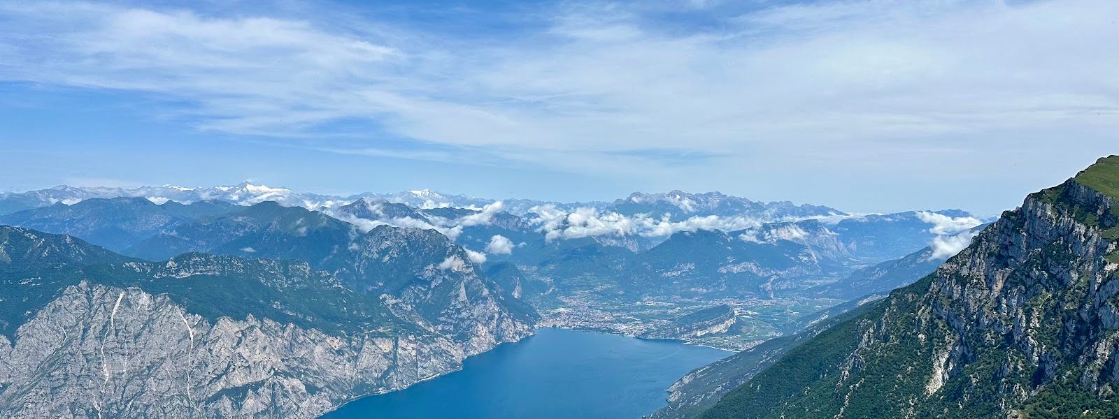
Mount Baldo is a mountain range in the Italian Alps, split between the provinces of Trento and Verona. Its ridge runs north-east to south-west for 40 km, with Lake Garda along the western side and the Val d'Adige to the east. The high point is Cima Valdritta at 2,218 m, followed by Punta Telegrafo at 2,200 m and Cima del Longino at 2,180 m, while the range bottoms out at 65 m on the lake. The Malcesine cable car reaches the ridge at Tratto Spino, and hiking trails, bike descents and paragliding launches run from there.
Mount Baldo
Local name: Monte Baldo
The name comes from the German Wald, «forest» — it turns up on a German map as early as 1163.
- Entrance
- No admission charge for the mountain itself; the cable car from Malcesine is a paid ride.
- Parking
- Nearest car park about 1.2 km away; a second, asphalt-surfaced one at roughly 2.1 km.
- Difficulty
- Anything from easy panoramic walking near the top station to exposed ridge routes: dangerous but doable, and demanding good fitness. Highest point Cima Valdritta, 2,218 m.
- Transport
- Nearest bus stop is Hotel Lido, about 4 km away.
- Hours
- The mountain is open around the clock. The cable car runs to its own timetable — check it before planning a late descent.
What makes it special
The climb is the point. Down at the water the slopes are Mediterranean scrub; up on the crest it is alpine meadow and bare rock. Around 2,000 plant species live in that spread, which is what earns the range its nickname, the Botanical Garden of Europe, and marmots, chamois and raptors work the same ground. The Malcesine cable car has rotating cabins, so the lake unwinds through a full 360 degrees on the way up, and on a clear day the Dolomites stand out on the horizon. From the top station the trail network fans out: gentle panoramic walking on The Colma, the exposed Ventrar Path along the flank, single-track descents for bikes, and paragliders launching straight out over Lake Garda.
Good to know
- Cold at the top: the crest runs windy and cold while the shore below is hot, so carry warm layers whatever the month.
- No toilets or drinking water nearby: none within 800 m of here; the restaurants and cafés are up on the mountain.
- Bikes ride the cable car: take yours up in the cabin and come back down the single-track towards Malcesine.
- Winter is a different mountain: skiing, snowboarding, snowshoeing and tobogganing take over from the hiking.
Getting there
Most people arrive in Malcesine on the lake shore and let the cable car do the work: the rotating cabins lift you from the town to Tratto Spino at around 1,800 m, and the ridge paths begin at the top station. Bikes go up in the cabin with you. Walking up from the water is possible — the range climbs from 65 m at the lake to over 2,200 m on the crest — but that is a full mountain day, not an afternoon's outing. Arriving by car, the nearest car parks sit back down the road, so the last stretch is on foot either way.
Best time to visit
Better: a clear day, early morning or late afternoon; spring and early summer for the flowers.
Avoid: the middle of a summer day, and hazy weather of any kind.
The views across Lake Garda and out to the Dolomites are the whole reason to come up, and haze cancels them. Early and late also dodge the thickest of the summer crowds. Do not count on snow at the top outside winter — a July visitor found none, and humid air with it.
Sun & daylight
Nearby Places
Mount Baldo on the map
The crest is cold and windy even when the lakeshore is in high summer — carry warm, windproof layers. Ridge hiking here is exposed and demanding: doable, but dangerous, and good fitness is not optional on the harder routes.
Get directions

Your whole travel map in one place
Get inspired by new places around the world and find the ones worth the journey
Frequently asked questions
How do you get to the top of Mount Baldo?
A cable car from Malcesine, on the shore of Lake Garda, runs up to Tratto Spino at around 1,800 m; its cabins rotate as they climb. Hiking trails reach the ridge as well, and bikes can be carried up in the cabin.How high is Mount Baldo?
The high point is Cima Valdritta at 2,218 m. Punta Telegrafo reaches 2,200 m, Cima del Longino 2,180 m, Cima delle Pozzette 2,132 m and Monte Altissimo di Nago 2,079 m. The range drops to 65 m where it meets Lake Garda.Why is it called the Botanical Garden of Europe?
Because of the vertical spread. The range carries around 2,000 plant species, from Mediterranean vegetation at lake level to alpine meadow and rocky summits, along with marmots, chamois and raptors. Spring and early summer are the flowering months.Can you hike Mount Baldo without using the cable car?
Yes. The trail network covers everything from easy meadow walking to hard ridge routes up to Cima Valdritta, and the Peace Trail (Sentiero della Pace), one of the main long-distance routes in northern Italy, crosses the range.