Pisão Bridge carries a levada path across a ravine above Funchal, on the Portuguese island of Madeira. The draw is the waterfall beside it, which runs outside the summer and dries up in the heat. The approach from the east comes through a tunnel; crossing the bridge sends the route west on a longer walk into wilder country. The last part is walked either way — the nearest car park is about 1.4 km off, and driving directions to the bridge lead to the wrong entrance.
Pisão Bridge
Local name: Ponte do Pisão
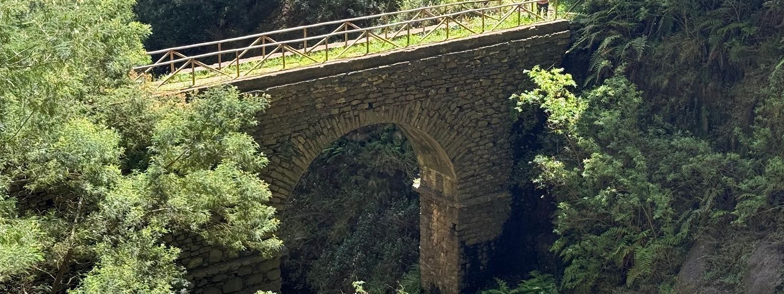
The waterfall next to the bridge runs dry through the summer, and the walk is then all there is.
- Parking
- Free car park with asphalt surface, about 1.4 km from the bridge.
- Difficulty
- Levada walking, with a tunnel on the approach from the east. The route west across the bridge is longer and rougher.
- Transport
- Bus stops Monte Lombos and CAM Lombos Depois Pintor, both about 900 m away.
What makes it special
A levada path, a tunnel and a bridge over the water — and beside the bridge, the waterfall that makes the walk worth it. The waterfall is seasonal: through the summer it runs dry, and what is left is the levada, the ravine and the walking. From the east the last stretch reaches the bridge through a tunnel, and few people step into it without a pause at the mouth. Cross the bridge and the route carries on west, longer and further into the hills. Take the path to the left of the tunnel exit instead, off the levada, and it drops south to a residential road. Getting here is the hard part: driving directions to the bridge end at a place with no way in.
Good to know
- Google Maps: the driving directions end at a point with no way in. Aim for the car park and walk in along the levada.
- Summer: the waterfall beside the bridge is dry through the summer months. The walk still works, the water does not.
- No facilities: no toilets, drinking water or information boards near the bridge. Carry water in.
- The tunnel: the approach from the east runs through a tunnel, and the path left of its exit, off the levada, runs south to a residential road.
- Over the bridge: the route west across the bridge is a longer walk into wilder country.
Getting there
Car or bus, then legs. There is no driving to the bridge itself: the nearest car park leaves about 1.4 km to cover on foot, and the way in is the levada path. Bus stops sit on the road above, closer than the car park. The driving directions are the trap — they end at a point with no access, and people have turned back without finding the bridge at all. From the east the path runs into a tunnel and the bridge lies beyond it.
Best time to visit
Better: outside the summer, when the waterfall beside the bridge is running.
Avoid: the summer months — the falls dry up and there is no water at the end of the walk.
The water is the reason for the detour and the one thing here that changes with the calendar. The levada, the tunnel and the view down the ravine are the same in any month.
Sun & daylight
Nearby Places



Similar Places




Your whole travel map in one place
Get inspired by new places around the world and find the ones worth the journey
Frequently asked questions
Why does Google Maps not lead to Pisão Bridge?
The driving directions end at a point with no way in, and people have turned back without finding the entrance. Head for the car park and continue on foot along the levada.Is there a waterfall at the bridge?
Yes, beside the bridge. It runs dry through the summer months, so any other season is when to come for the water.What lies on the other side of the bridge?
The route west, which turns into a longer walk into wilder country. The path to the left of the tunnel exit, off the levada, runs south instead and comes out on a residential road.Are there toilets or drinking water?
No. There are no toilets, water points or information boards near the bridge, so bring what you need with you.