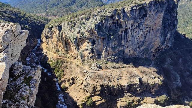
Sierra de Huétor is a limestone range of the Baetic System in the Province of Granada, just northeast of the city. Its summits run from 1,100 m to 1,675 m at Cerro Buenavista, and the range holds the deep valleys of the Darro and the Fardes, with cliffs, caves, narrow ravines and springs under shrubland and holm oak. Parts of the range, together with neighbouring sierras including the Sierra de la Alfaguara and the southern Sierra de Arana, make up the natural park.
Sierra de Huetor Natural Park
Local name: Parque Natural Sierra de Huétor

Limestone mountain park of holm oak, caves and ravines northeast of Granada, rising to 1,675 m.
- Entrance
- Free; there is no ticket.
- Accessibility
- Wheelchair-accessible parking. The walking routes climb into the mountains; on a 10 km walk, half the distance is uphill.
- Parking
- Car parks about 2.3 km away in a straight line; wheelchair-accessible parking available.
- Difficulty
- Mountain walking between 1,100 m and 1,675 m; a 10 km walk takes about three hours, half of it uphill.
- Transport
- Bus stop El Colmenar, about 2.8 km away in a straight line.
- Advance booking
- Not needed; the park is open at all hours and there is no ticket.
- Hours
- Open at all hours.
- Address
- Casa Forestal de los Peñoncillos, 18183 Huétor Santillán, Granada, Spain
What makes it special
Keep climbing and the views widen with every stretch of path, until Granada lies spread out below. The range rises from 1,100 m to 1,675 m at Cerro Buenavista, through holm oak and scrub on limestone cut by caves, cliffs and the deep valleys of the Darro and the Fardes. Golden eagles are among the birds that work the ridges.
History sits out in the open here. At Alfácar, the Fuente Grande spring fed the Moorish channel of Aynadamar, which carried its water down to the Albaicín. On Cerro de Maúllo, trenches and fortifications from the Spanish Civil War still mark the hilltop. In high summer the altitude takes the edge off the city's heat, and the higher ground is a fine place to watch the sun go down.
Good to know
- A walk of about 10 km takes around three hours, and half of it is uphill.
- Toilets are at the Puerto Lobo visitor centre. Out on the trails, carry all the water you need.
- Hikers and cyclists share the trails.
- Dogs are allowed, and the park suits families walking with children.
Getting there
The park lies northeast of Granada, around the villages of Huétor Santillán and Alfácar. The visitor centre at Puerto Lobo works as a trailhead: the staff will help you pick a route, and there are toilets before you set off on foot. Without a car, the nearest bus stop is El Colmenar, about 2.8 km away in a straight line, and the rest is on foot.
Best time to visit
Best: spring and autumn for long walks, and late afternoon for the sunset from the higher ground.
Avoid: the middle of a summer day on the uphill stretches.
The altitude keeps the range cooler than Granada, but a long climb in midsummer heat is hard going wherever the path leaves the trees, and in winter the upper slopes can carry snow and ice.
Sun & daylight
Nearby Places
Similar Places


Sierra de Huetor Natural Park on the map
Cliffs and narrow ravines cut through the range, and in the deeper woods it is easy to lose your way. Keep to the path and carry a map or a downloaded track.
Get directions
Your whole travel map in one place
Get inspired by new places around the world and find the ones worth the journey
Frequently asked questions
Is there an entry fee for Sierra de Huétor Natural Park?
No. The park is open at all hours and there is no ticket.How long does a hike in Sierra de Huétor take?
A walk of about 10 km from the Puerto Lobo visitor centre takes around three hours, with half of it uphill.Can you see Granada from the park?
Yes. Granada comes into view from the higher ground, and the views keep improving as you climb.Are dogs allowed in Sierra de Huétor Natural Park?
Yes, dogs are allowed in the park.What history can you find in the park?
The Fuente Grande spring at Alfácar fed the Moorish channel of Aynadamar, which carried water to the Albaicín, and Cerro de Maúllo still holds trenches and fortifications from the Spanish Civil War.