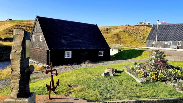
Hofsós is a village of fewer than 200 people on Skagafjörður, in northern Iceland. It is one of the oldest trading ports in the north of the country, in use since the 16th century and a Danish Trade Monopoly post in the 17th and 18th. Pakkhús, the warehouse of 1777, still stands and holds the Drangey Exhibition. The Icelandic Emigration Center (Vesturfarasetrið á Hofsósi) records the departure of Icelanders for North America. A path along the shore passes hexagonal basalt columns.
Hofsós

- Currency
- Icelandic króna (ISK)
- Language
- Icelandic; nearly all speak English
- Power plug
- Europlug and Schuko sockets, 230 V
- Visa
- Schengen; outside the EU
- Time zone
- UTC±00:00 (Atlantic/Reykjavik)
- Tap water
- Safe; hot water smells of sulphur
- Tipping
- Not customary
- Emergency
- 112
Things to do
All tours in Iceland on GetYourGuide
Paid links: booking through them supports YowJourney.
When to go
High season
Jun – Aug
At 65.9°N the nights barely darken. The shore path and its basalt columns can be walked late in the evening, and Höfðavatn holds its birdlife and its trout.
Shoulder
Sep – Oct
Daylight drops away fast and snow arrives on the higher ground. Road 76 into the village is still straightforward.
Low season
Nov – Mar
Just north of 65°N there are only a few usable hours of light in December. Snow and ice on road 76 make the drive in slow.
Shoulder
Apr – May
Light returns quickly and the days stretch out. Snow clears from the low coastal ground first, and the shore path is passable again.
How long to stay
Half a day covers Hofsós itself: the Icelandic Emigration Center, Pakkhús with the Drangey Exhibition, and the shore path below the village. Stay a night if you want the walk towards Thorðarhöfði and the lake behind it, or if you are working through Skagafjörður as a whole. Sauðárkrókur lies 37 km west and Hólar is a short detour off road 76.
Getting around
Hofsós has no bus service. Bus 57 from Reykjavík reaches Sauðárkrókur and Varmahlíð only, so the last leg is by car. From Varmahlíð on the ring road, road 76 runs north to Hofsós; road 75 goes to Sauðárkrókur, 37 km west of the village. Hólar is reached on road 76 and then road 767. The nearest airport with scheduled flights is Akureyri, 94 km from Varmahlíð. Inside the settlements of Skagafjörður, walk: no distance exceeds 3.2 km.
What to see
Destinations in Hofsós
Frequently asked questions
How do you get to Hofsós?
By car, on road 76 north from Varmahlíð on the ring road. Bus 57 from Reykjavík serves Sauðárkrókur and Varmahlíð, but not Hofsós. The nearest airport with scheduled flights is Akureyri, 94 km from Varmahlíð.What is there to see in Hofsós?
The Icelandic Emigration Center covers the westward migration of Icelanders to North America, which peaked at the start of the 20th century. Pakkhús, the warehouse of 1777, holds the Drangey Exhibition. The path along the shore passes hexagonal basalt columns.Is there anywhere to stay or eat?
The village has guesthouses, a restaurant, a coffee-house and a camping site.What is Thorðarhöfði?
A headland that stands well out from the main shore and looks like an island. Low sandpits join it to land and enclose a sizeable lake, Höfðavatn, with plentiful birdlife and good trout fishing.Why is Mannskaðaholl called Massacre hill farm?
The farm at the south end of Höfðavatn is named for the massacre of English marauders that took place there in 1431.