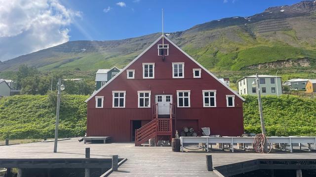
Siglufjörður sits in a narrow fjord of the same name on the north coast of Iceland. The population is about 1,200, down from a peak of 3,000 in the 1950s. Herring built the town: salting first, then a dedicated factory, and the fishery collapsed after 1970. The Herring Era Museum (Síldarminjasafn) opened in 1994 in Róaldsbakki, a building of 1907. Two road tunnels link the town to the rest of North Iceland. The 2015 series Trapped (Ófærð) was filmed almost entirely here.
Siglufjörður

- Currency
- Icelandic króna (ISK)
- Language
- Icelandic; nearly all speak English
- Power plug
- Europlug and Schuko sockets, 230 V
- Visa
- Schengen; outside the EU
- Time zone
- UTC±00:00 (Atlantic/Reykjavik)
- Tap water
- Safe; hot water smells of sulphur
- Tipping
- Not customary
- Emergency
- 112
Things to do
All tours in Siglufjörður on GetYourGuide
Paid links: booking through them supports YowJourney.
When to go
High season
Jun – Aug
The midnight sun lasts from 9 June to 1 July. The old mountain road over Siglufjarðarskarð is open, and the town fills for the folk music festival in July and the Herring Festival in August.
Shoulder
Sep – Oct
Daylight shortens quickly at 66°N. The mountain road shuts for the year and all traffic goes through the tunnels.
Low season
Nov – Mar
There is no polar night, but on 21 December daylight lasts 2 hours 39 minutes. The tunnels keep the road open, and this is the winter sports season.
Shoulder
Apr – May
Daylight returns fast and the town is quiet before the summer festivals. The mountain road is still closed.
How long to stay
A day covers the town itself. The Herring Era Museum, the church, the harbour memorial and the old wooden houses all lie within that 2.2 km walk. Add a night if you have come for the ski lifts in winter, for the folk music festival in July or for the Herring Festival in August. Siglufjörður also works as a base for a day or two on the north coast, with Akureyri an hour away by road.
Getting around
There is no bus service inside the town, and none is needed. The longest walk from one end to the other is 2.2 km. Road access comes through tunnels from both directions. Road 76 arrives from the west through Strákagöng, which has been the year-round link since 1967; road 82 arrives from the east through the Héðinsfjörður tunnels (Héðinsfjarðargöng), open since 2010. Bus 78 runs from Akureyri. The old mountain road over Siglufjarðarskarð, the highest road in Iceland, is open in summer only and is used for hiking, horse riding and driving for pleasure. The town has a small airfield, but it has had no scheduled flights for many years. The nearest airport with them is Akureyri, an hour's drive away.
What to see

Destinations in Siglufjörður
Frequently asked questions
How do you get to Siglufjörður?
By car from the ring road: turn onto road 76 a few kilometres past Varmahlíð coming from the west, or onto road 82 a few kilometres past Akureyri coming from the east. Both routes end in Siglufjörður. Bus 78 runs from Akureyri, an hour away and the nearest airport with scheduled flights.Do you need a car once you are in the town?
No. There is no bus system within Siglufjörður and the longest walking distance is 2.2 km.What is the Herring Era Museum?
A maritime museum that opened in 1994, in Róaldsbakki, a historic building of 1907. It covers the herring industry that dominated the town between 1900 and 1960, from salting stations to the processing factory.Was Trapped filmed in Siglufjörður?
Yes. Baltasar Kormákur's 2015 series Ófærð (Trapped) was shot almost entirely in the town, apart from a few outdoor scenes in the Eastfjords and Reykjavík. Siglufjörður is also the setting of Ragnar Jónasson's Dark Iceland novels.Can you ski at Siglufjörður?
The town became Iceland's centre of winter sports, with two ski lifts and a ski jump hill. A snowslide destroyed the ski area in January 2021. Check the current state of the slopes before planning a trip around them.