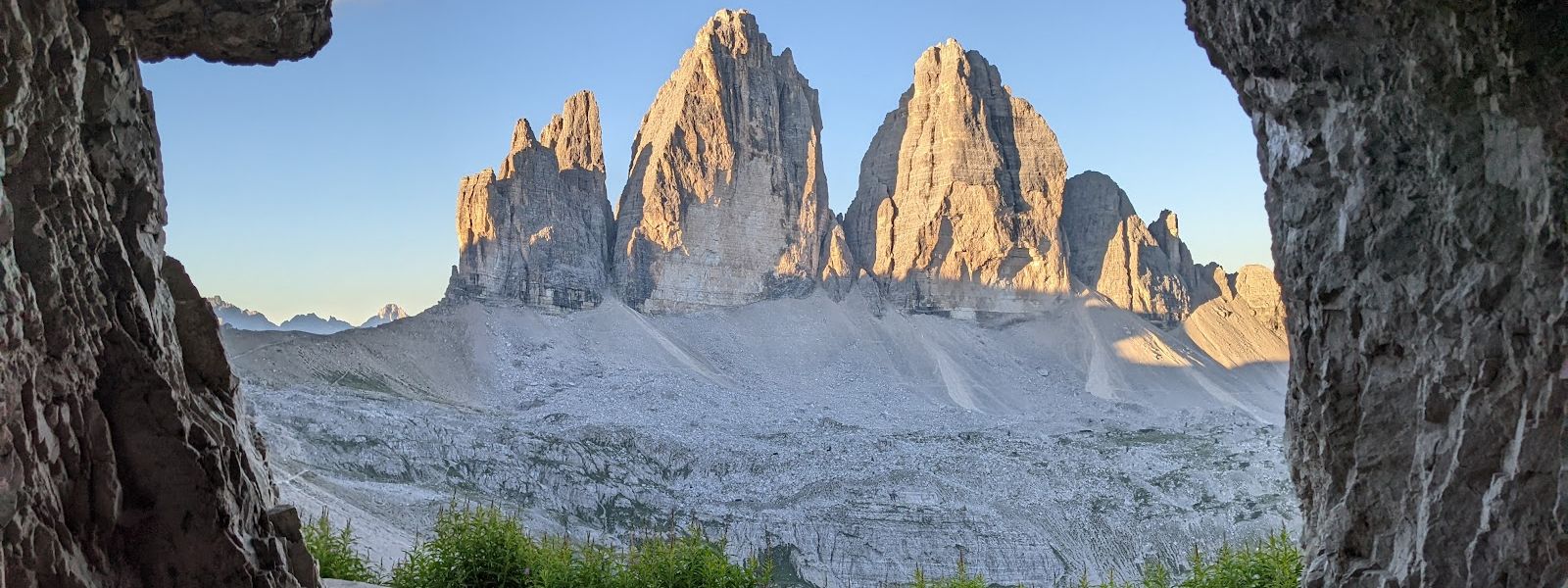
Grotta delle Tre Cime is a cave on the Tre Cime di Lavaredo walking circuit above Sesto, in the Dolomites of northern Italy. It lies about three kilometres from the Rifugio Auronzo car parks and roughly two hours on foot from the trailhead, and it is visited mainly as a photo spot, with the rock opening framing the peaks around it. The cave is open at all hours and free, but driving into the park requires a parking spot booked online in advance. The final stretch of the trail is rugged and uneven.
Grotta delle Tre Cime
In winter snow closes the access road, so the trailhead alone is a 6 km walk before the hike to the cave even begins.
- Entrance
- Free; the cave stands open on the trail.
- Accessibility
- Not wheelchair accessible: no step-free entrance and no accessible parking spaces.
- Parking
- Paid gravel car parks P3 and P4 at Rifugio Auronzo, about 3 km from the cave.
- Difficulty
- About two hours on foot from the trailhead; the final stretch is rugged and uneven and ends in a sharp climb.
- Transport
- Nearest bus stop: Rifugio Auronzo, about 3.1 km from the cave; Fischleintalboden – Pian di Val Fiscalina about 4.6 km.
- Advance booking
- A parking spot must be booked online in advance to drive into the park.
- Hours
- Open 24 hours, every day of the week.
What makes it special
The draw is the frame. From the mouth of the cave the Dolomite towers stand inside a ring of dark rock, and that picture is what pulls people up here. Getting to it is the other half of the day. From the trailhead the walk runs about two hours out along the Tre Cime di Lavaredo circuit, with the peaks in sight most of the way, until the last stretch turns rugged and uneven and finishes in a sharp climb. The refuge below draws crowds; up at the cave the walking is quiet, and the difference is those final metres.
Good to know
- Bring boots with grip and poles: the last climb to the cave mouth is where they earn their keep.
- Winter calls for snowshoes: on snow the same route takes twice the effort it does in summer.
- Toilets and water are close: free toilets about 170 m from the cave, drinking water about 260 m, information boards about 130 m.
Getting there
The last leg is on foot, and it is not a short one. Cars go as far as the Rifugio Auronzo car parks, roughly three kilometres from the cave, and the bus stop of the same name sits a little further out again. From the trailhead the walk takes about two hours along the Tre Cime di Lavaredo circuit. At the refuge the way on to the cave is not obvious; other walkers on the trail point out the sharp climb that leads up to it. Underfoot, the final stretch is rugged and uneven.
Best time to visit
Better: summer, when the access road is open and the walk starts from the Rifugio Auronzo car parks.
Avoid: winter without snowshoes.
Snow shuts the road and buries the route, and the same walk then takes twice the effort it does in summer — on top of the two hours the approach already needs from the trailhead.
Sun & daylight
Nearby Places

Similar Places

Featured in our guides
Grotta delle Tre Cime on the map
The final approach is rugged and uneven and ends in a sharp climb. A slip there leaves you about three kilometres from the nearest car park, high on the circuit and a long way from any road.
Get directions

Your whole travel map in one place
Get inspired by new places around the world and find the ones worth the journey
Frequently asked questions
How long does the walk to the cave take?
About two hours on foot from the trailhead, along the Tre Cime di Lavaredo circuit. The final stretch is rugged and uneven and ends in a sharp climb.Does anything have to be booked in advance?
Yes. A parking spot must be booked online before you can drive into the park and start the hike, and the parking is paid.Can the cave be reached in winter?
Yes, but snow closes the access road: the trailhead itself becomes a 6 km walk, and without snowshoes the route takes twice the effort of the summer walk.Is there a bus stop nearby?
The nearest stop is Rifugio Auronzo, about 3.1 km from the cave. Fischleintalboden – Pian di Val Fiscalina is about 4.6 km away.