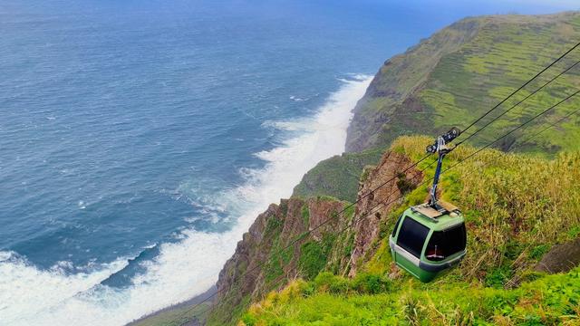
Ladeira Trail is a hiking route on the north-west coast of Madeira, in the Santa Maria Madalena area. It links the clifftop with the coast at Achadas da Cruz, descending about 500 metres to a pebble beach — the same point the cable car serves. The route runs about 3 km, with roughly 1,000 metres of ascent and descent in total, and takes 1.5 to 2 hours there and back. Waterfalls, the ocean and the cliffs opposite stay in view for much of the descent.
Ladeira Trail
Local name: Vereda da Ladeira

Three kilometres of path, with about 1,000 metres of climbing and descending packed inside them.
- Accessibility
- Not suitable for wheelchairs or limited mobility: the route is a steep 500-metre descent and climb.
- Parking
- Free parking about 1 km from the trailhead, open access.
- Difficulty
- Steep throughout: about 3 km, roughly 500 m down and 500 m back up, 60–90 minutes each way. Hiking shoes needed.
- Transport
- Nearest bus stop about 1.1 km from the trailhead; no route number recorded.
What makes it special
The path leaves the clifftop and keeps dropping — about 500 metres of descent to the shore, with waterfalls, open ocean and the cliffs on the far side of the valley in view for most of the way down. The vegetation shifts as you go, one band of flowers and plants giving way to the next between the top and the sea. It ends at a pebble beach below Achadas da Cruz, where the cable car comes down. Walking is the other way in and out, and it costs about 3 km of path and roughly 1,000 metres of climbing and descending in total.
Good to know
- Footwear: the path is steep the whole way — hiking shoes rather than trainers.
- The climb back: about 500 metres of ascent to return, 60–90 minutes at a steady pace.
- Parking: free, about a kilometre from the trailhead; the last stretch is on foot.
- No toilets: none at the trailhead, and none within 800 metres of it.
- Water: a drinking water point sits about 280 metres from the trail — fill up before dropping down.
Getting there
Drivers park free about a kilometre from the trailhead and cover the rest on foot; the nearest bus stop is a similar distance away. From the top the path descends around 500 metres to the beach — 60 to 90 minutes down at a steady pace, and about the same again on the climb back.
Sun & daylight
Nearby Places

Similar Places


Ladeira Trail on the map
The path is steep from top to bottom, and the 500 metres you descend have to be climbed again on the way back. Wear hiking shoes, and turn round early if you are not sure of the return climb.
Get directions

Your whole travel map in one place
Get inspired by new places around the world and find the ones worth the journey
Frequently asked questions
How long does the walk take?
Between 1.5 and 2 hours for the round trip — 60 to 90 minutes each way if you do not stop long for rest or photographs.How much height do you lose and gain?
The path drops about 500 metres to the coast and climbs the same on the way back: roughly 1,000 metres of ascent and descent over about 3 km.Where does the trail end?
At the pebble beach below Achadas da Cruz, the same point the cable car serves.Is there parking?
Yes — free parking about a kilometre from the trailhead, with the remaining distance on foot.Are there toilets?
No. There are none at the trailhead and none within 800 metres of it.