Pico Grande is a peak in the central mountains of Madeira, above Curral das Freiras, reached only on foot. The usual approach starts at the Boca da Corrida viewpoint and follows the path along the range before turning up towards the summit. The climb from there is continuous, and the last part is steep enough to need rails. The top looks down into the valley and across the central massif, which is what draws walkers up. There are no facilities on the mountain and no shade for most of the route.
Pico Grande Viewpoint
Local name: Pico Grande
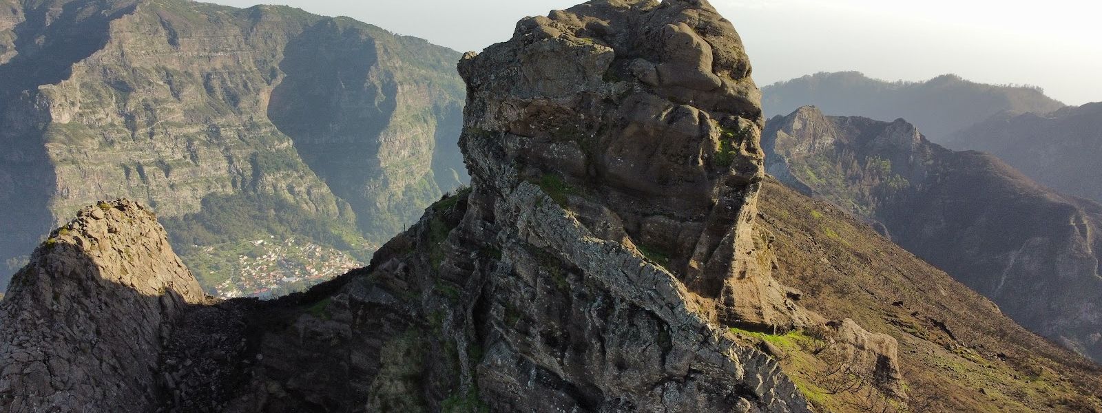
The approach out of Boca da Corrida is the easy part — Pico Grande itself begins where the path turns uphill and stops levelling out.
- Accessibility
- Not wheelchair accessible: no step-free entrance, and the summit is reached only by a steep mountain path.
- Parking
- Nearest mapped car park about 1.7 km from the peak; a second one about 2.6 km away.
- Difficulty
- Just over 6 miles (about 10 km) round trip from Boca da Corrida; easy for the first hour, then continuous uphill and a steep, exposed final climb.
- Transport
- Bus stops CAM da Fajã Escura 2A and 3A, about 1.65 km from the peak.
- Hours
- Open around the clock.
What makes it special
The path out of Boca da Corrida is gentle enough that the first stretch feels like a stroll along the flank of the range. Then the turn-off appears, the walking becomes climbing, and it stays that way to the top. The summit block is the part people remember: a steep face taken with the help of rails, the ground open on one side, and a spot to sit at the top with Curral das Freiras (the Nuns' Valley) far below and the central peaks stacked behind it. Most of the route runs in the open, with no shade to duck into.
Good to know
- No toilets — nothing mapped within 800 m of the peak, and no information point either.
- Exposed the whole way — most of the route has no shade, so carry sunscreen; walking poles earn their place on the climb.
- Wet weather stops it — several parts of the trail are not fit to walk in rain, and the final kilometre turns slippery.
- Refills on the route — waterfalls along the way are used for filling bottles, so you can set off carrying less.
- A head for heights is needed — the ascent runs with drops to one side, and the last stretch turns some walkers back.
Getting there
No road reaches Pico Grande. Walkers start at the Boca da Corrida viewpoint and follow the path along the range before the turn-off towards the peak, and from there it is uphill with nothing flat to recover on. The final part is a climb rather than a walk: a steep face with rails on some sections. The return is back down the same way.
Best time to visit
Better: clear, dry weather, and sunrise or sunset if you want the summit to yourself.
Avoid: rain — several sections of the trail are not fit to walk wet.
The view is the reason for the climb, down into Curral das Freiras and across the peaks around it, and in cloud there is nothing to see from the top.
Sun & daylight
Nearby Places


Similar Places


Pico Grande Viewpoint on the map
The final kilometre is the dangerous part: steep, slippery underfoot and without railing, with drops to one side. Walkers do turn back there. Do not push on in wet weather — several sections of the trail are not safe to walk when it rains.
Get directions

Your whole travel map in one place
Get inspired by new places around the world and find the ones worth the journey
Frequently asked questions
How long is the hike to Pico Grande?
Just over 6 miles (about 10 km) there and back from Boca da Corrida, with roughly the first hour spent walking before the turn-off up to the peak.How hard is it?
Easy as far as the turn-off, then uphill without a break. The ascent to the top is steep, with rails on some sections and drops to one side, and calls for fitness and a head for heights.Can you drive to the top?
No. The peak is reached on foot only; the nearest mapped car park lies about 1.7 km away, and the walk itself starts at Boca da Corrida.Are there toilets or drinking water on the route?
No toilets and no information point within 800 m of the peak. Waterfalls on the route are used to refill bottles.Is it worth going in the rain?
No. Several parts of the trail are not fit to walk in wet weather, the last kilometre becomes slippery, and cloud takes the view away.