Lake Braies lies at the head of the Prags Valley in the Dolomites of South Tyrol, inside the Fanes-Sennes-Prags nature park. A landslide off the Herrstein dammed the Prags stream and left 31 hectares of water, 1.2 km long and 36 m deep at the most, held between Dolomite peaks on three sides. People come for the colour of the water and the path round the shore; rowing boats are hired at the northern end, and the Alta Via 1 high route starts there. Summer numbers are heavy, and parking is booked ahead.
Lake Braies
Local name: Lago di Braies

In April 1945 the SS ended a transport of concentration camp prisoners on this shore, holding them here in the last weeks of the war.
- Entrance
- No admission ticket for the lake; parking is what costs money.
- Accessibility
- Wheelchair-accessible parking, entrance and toilets. The western bank path is flat and wide; the eastern bank is steep and narrow with stairways.
- Parking
- Car parks 650–800 m from the shore: paid P4 at the far end, some free street parking closer in. A slot must be booked in advance for summer visits.
- Difficulty
- Shore loop round a lake 1.2 km long: level and wide on the western bank, narrow and steep with stairways on the eastern.
- Transport
- Bus 445 from Cortina, change at Dobbiaco to bus 422; stop Pragser Wildsee – Lago di Braies, about 790 m from the lake.
- Advance booking
- Parking must be booked in advance for summer visits.
- Hours
- Open around the clock. Vehicle access up the valley road is restricted during the day in summer.
What makes it special
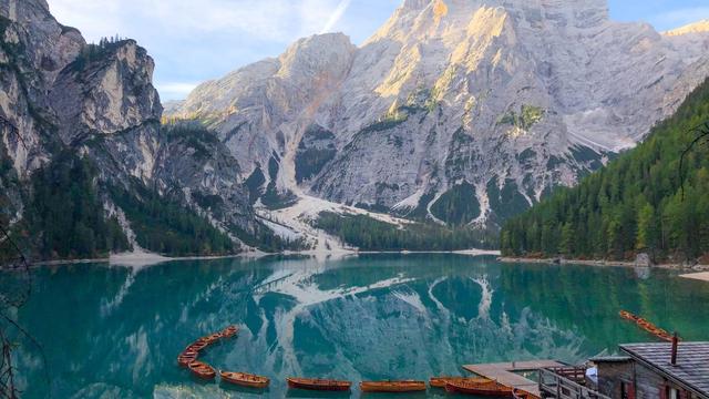
The water reads green in the shallows by the boathouse and turns deep blue further out, with the grey wall of the Seekofel (Croda del Becco, 2,810 m) closing the far end. The lake runs 1.2 km long and 300–400 m wide, dammed by a landslide off the Herrstein that blocked the Prags stream, and it sits inside the Fanes-Sennes-Prags nature park with Dolomite peaks on three sides. The shore circuit is not one path but two: wide and flat along the western bank, narrow and steep with stairways along the eastern. Wooden rowing boats go out from the north shore, and the track at that end is the start of the Alta Via 1, the classic Dolomite high route that runs south to Belluno. Television did the rest — the series Un passo dal cielo was filmed here from 2010, and the lake became one of the most visited places in South Tyrol.
Good to know
- Book parking before you drive up. For a summer visit a car park slot has to be reserved in advance, and vehicle access up the valley has been restricted since 2023.
- Food and toilets are at the north end. Restaurants and toilets stand where the road stops; some toilets are free, others charge.
- The eastern bank is the hard side. Narrow, steep and stepped, and in winter it is the first path shut for avalanche danger.
- The water stays cold. It peaks at 14 °C in high summer, over a lake 36 m deep at its deepest point.
Getting there
The approach is from the north, up the valley road; Dolomite walls close the other three sides. Cars stop 650–800 m short of the water, the paid P4 being the furthest of them, and the bus stop sits about the same distance out, so the last stretch is done on foot along the valley floor to the top end of the lake. The shore loop starts there, by the boathouse and the restaurants; the western bank is the flat, wide way round if you only want part of it.
Best time to visit
Better: early morning or the last hours of the day, and June over August.
Avoid: the middle of an August day — the record here is 17,874 visitors in twenty-four hours.
The Seekofel closes the southern end and takes the first sun while the water is still in shade, and the west-bank path is quiet before the day's arrivals work their way round it. Evening holds up too: the lake was barely busy at five in the afternoon in early June, before the season peaked. In winter the surface freezes hard enough for curling matches, but the shore paths are often shut.
Sun & daylight
Nearby Places

Similar Places
Featured in our guides
Lake Braies on the map
In winter the shore paths, the eastern one above all, are often closed because of avalanche danger. Do not step round a closure: that bank is narrow, steep and stepped, with the slope running straight down to the water.
Get directions

Your whole travel map in one place
Get inspired by new places around the world and find the ones worth the journey
Frequently asked questions
How long does it take to walk around Lake Braies?
One to one and a half hours at a relaxed pace, closer to two with stops for photographs. One visitor ran a full loop plus a stretch of the far bank and logged about 6 km with 180 m of ascent.Can you reach Lake Braies by public transport?
Yes. A bus runs up the valley from Dobbiaco to a stop about 790 m short of the lake; coming from Cortina means one change.Can you hire a boat on the lake?
Yes, rowing boats go out from the north shore. Outside the busiest hours the wait is short — ten minutes for a boat at five in the afternoon in early June.Is the lake manageable with a pushchair or a wheelchair?
The western bank path is flat and wide, and there is wheelchair-accessible parking, an accessible entrance and accessible toilets. Turn back at the far end rather than carrying on round the eastern bank, which has stairways.Is Lake Braies worth a visit in winter?
The lake freezes, and curling competitions have been held on the ice since 2012. The shore paths, especially the eastern one, are often closed in that season because of avalanche danger.