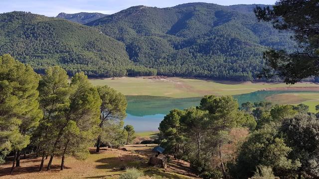
Montes de Málaga Natural Park protects part of the Montes de Málaga, a range of the Penibaetic System named after the city at its foot. The range runs between the Guadalhorce valley to the west and the Axarquía to the east, and its highest point is Cresta de la Reina at 1,030 m. The Guadalmedina river crosses it, fed by streams that are dry most of the year. The park is known for dense pine forest, valleys, walking and cycling routes and 19th-century farmhouses.
Montes de Malaga Natural Park
Local name: Parque natural Montes de Málaga

Natural park of dense pine forest in the hills behind Málaga, crossed by walking and cycling trails.
- Accessibility
- No wheelchair-accessible parking. Trails run on dirt tracks; a pushchair copes on the wider ones.
- Parking
- Explanada de Contadoras, sand surface; also behind the Venta Pinar bar on the Málaga road out of Colmenar. No wheelchair-accessible parking.
- Difficulty
- Walks suit all ages. Trails are well signposted; the yellow trail climbs on a dirt track to views at the top.
- Hours
- Open 24 hours, every day.
- Address
- Casabermeja-Colmenar, Málaga, Spain
What makes it special
Up here the beach and the city traffic are gone, and the air smells of resin and warm pine needles. The pines grow dense across the valleys, and the 19th-century farmhouses scattered among them belong to the vineyards that covered these slopes before the forest was planted.
A web of signposted trails and cycle routes runs through the trees. The yellow trail climbs on a dirt track, and the reward comes at the top: wide views over the hills and down towards Málaga and the sea. In May and June the slopes are in flower. Roadside ventas along the main road serve food with the same views, which is where most walks here end.
Good to know
- Come in from the south. The western approach means driving across a river with a nasty drop at its edge.
- Carry water. The streams are dry most of the year.
- Leave the car early. Tracks inside the park are rough for an ordinary car; park and carry on by foot.
- Dogs and children are welcome. The walks suit all ages, and a pushchair copes on the wider tracks.
Getting there
You arrive by car and finish on foot. Approach from the south: the western way in drives across a river with a nasty drop at the side.
One walk starts on the Málaga road out of Colmenar. Follow it until the Venta Pinar bar and a sawmill appear, park behind the bar, and the trail begins there. Inside the park, Explanada de Contadoras is a parking area with a sand surface. Beyond the main road the tracks are rough for cars, so leave the car at a parking area and continue on foot. The trails themselves are well signposted.
Best time to visit
Best: May and June. The slopes are in flower, and the Andalusian summer heat has not yet arrived.
Avoid: midday in high summer. The tracks lie open to the sun, and the dry pine forest is at its greatest fire risk.
Sun & daylight
Nearby Places
Similar Places
Montes de Malaga Natural Park on the map
The western approach crosses a river by car with a sharp drop at its side; come in from the south. In summer the pine forest is tinder-dry, so never light a fire or drop a cigarette.
Get directions
Your whole travel map in one place
Get inspired by new places around the world and find the ones worth the journey
Frequently asked questions
When is Montes de Málaga Natural Park open?
The park is open 24 hours a day, every day.Which way should I drive into the park?
Come in from the south. The western approach involves driving across a river with a nasty drop at its edge.Where can I start a walk?
On the Málaga road out of Colmenar, park behind the Venta Pinar bar next to the sawmill; a walk starts there. Explanada de Contadoras also has a sand-surfaced parking area.Is the park suitable for children and dogs?
Yes. Dogs are allowed, the walks suit all ages, and a pushchair copes on the wider tracks.