Dyrhólaey is a headland on the south coast of Iceland, near Vík í Mýrdal in South Iceland. A lighthouse stands on the high point, and a natural arch is cut through the rock at the tip of the promontory. Below are black sand beaches and open ocean. The cliffs are one of the best-known puffin spots on the south coast. The site has fixed opening hours, and cliff paths link the top with the lower area. Strong wind and fast weather changes are part of the visit.
Dyrholaey Viewpoint
Local name: Dyrhólaey útsýnisstaður
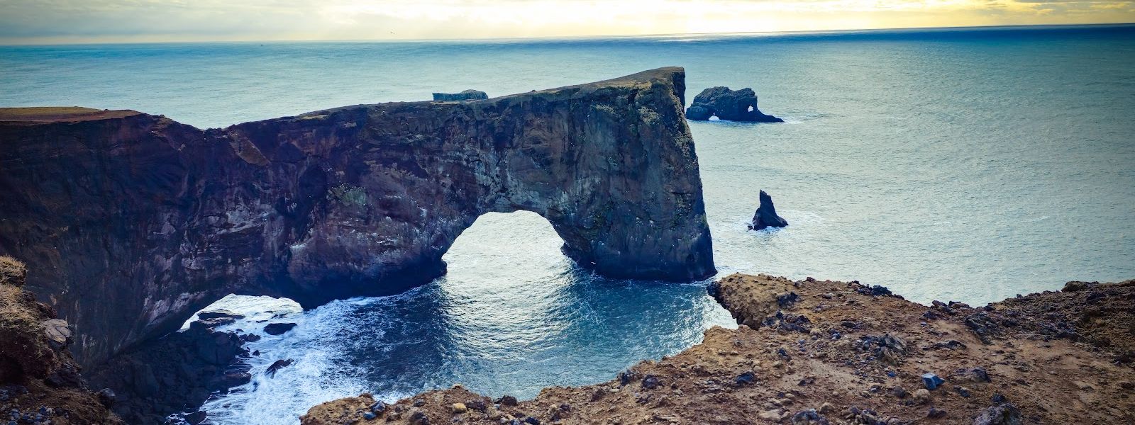
The lighthouse, the sea arch and the black sand beach are all in view from the same headland.
- Entrance
- Entry is charged. Payment is at a machine by the car park near the lighthouse.
- Accessibility
- You can drive up to the lighthouse and park on asphalt at the top; the cliff paths between the upper and lower areas are the only way round on foot.
- Parking
- Two car parks: one on top by the lighthouse, one lower down. Both are asphalt and both charge a fee. The upper one is small and fills at busy times.
- Difficulty
- Cliff paths link the lighthouse with the lower area; walking down took one group about an hour and a half. The access road is a graded switchback, and the top is fully exposed to wind.
- Transport
- No public transport — no bus stop within five kilometres. Arrive by car or on a tour.
- Hours
- Daily 9:00–19:00.
- Address
- 871 Vík, Iceland
What makes it special
Four things sit within one walk here: the lighthouse on the headland, the sea arch cut through the rock, the black sand beach below and the open ocean beyond it. Dyrhólaey is one of the best-known puffin spots on the south coast, but sightings are not certain — a group on 12 May found the cliffs empty. Cliff paths run from the lighthouse down towards the lower area, with the surf breaking under them. The top is fully exposed. There is no shelter from the wind anywhere on the headland, which is why most people photograph the arch and leave quickly.
Good to know
- No toilets at the cliffs. The nearest ones are off the headland, so use them before you drive up.
- Dress for wind. Windproof clothing is what counts here; there is no shelter on the top.
- Puffins are not guaranteed. A group visiting on 12 May saw none at the cliffs.
- The cliff walk is not short. From the lighthouse down to the lower area took one group about an hour and a half.
Getting there
The last stretch is a graded switchback climbing onto the headland — take it slowly if you are driving yourself. You can drive right up to the lighthouse at the top, and a second area sits lower down, linked to it by cliff paths. Some groups walk down and leave one driver to bring the car round and meet them below. There is no bus: no stop lies within five kilometres of the site.
Best time to visit
Better: soon after opening, before the car park on top fills.
Avoid: the peak of the puffin season, when finding a space is hardest.
The opening hours rule out sunrise and late evening through most of the summer, so plan for daylight hours. Weather on the headland changes within minutes rather than hours: one April visit ran through sun, sleet and rain in a quarter of an hour on the cliff top.
Things to do nearby
All tours in South Iceland on GetYourGuide
Paid links: booking through them supports YowJourney.
Sun & daylight
Nearby Places



Similar Places


Dyrholaey Viewpoint on the map
The wind on top is strong enough to move you — on one April visit people had to stand sideways into it to stay upright. Hold on to your car door when you open it, or a gust will take it.
Get directions

Your whole travel map in one place
Get inspired by new places around the world and find the ones worth the journey
Frequently asked questions
Can you see puffins at Dyrhólaey?
It is one of the most famous puffin-viewing spots on the south coast, but sightings are not guaranteed. A group visiting on 12 May saw none at the cliffs.What else is there to see besides puffins?
The lighthouse on the headland, the sea arch cut through the rock, and the black sand beach below, with the coast running away on both sides.How long does the walk along the cliffs take?
Walking down from the lighthouse to the lower area took one group about an hour and a half. Some parties send a driver down by car to meet the walkers there.What is the drive up like?
A graded switchback climbs to the lighthouse. Be ready for it if you are driving yourself, and expect high wind at the top.