Huldujokudl Viewpoint is a scenic spot in South Iceland, on high ground above the tongue of a glacier. It is reached only on foot, as a detour from the yellow hiking route out of Thakgil. From the edge the seracs are close, three waterfalls are in view, and blocks of ice break off the glacier front with a loud crack. The trail climbs and drops steeply, and the place stays quiet even in high summer.
Huldujokudl Viewpoint
Local name: Huldujökull

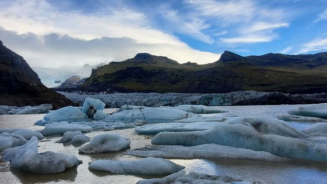
Blocks of ice break off the glacier tongue below the viewpoint, and the sound of them landing carries up to the edge.
- Accessibility
- No wheelchair access: the approach is a steep hiking trail.
- Parking
- Two unnamed car parks about 4.7 km from the viewpoint; the rest of the way is on foot.
- Difficulty
- Steep ascent and descent, several kilometres each way from the nearest car park; very slippery in rain above the camp.
- Hours
- Open 24 hours.
- Address
- Þakgil, 871, Iceland
What makes it special
The edge of the viewpoint is directly above the glacier's tongue, close enough to pick out individual seracs. Ice breaks off the front and lands with a crack loud enough to make people at the top jump. Three waterfalls are in view from the same spot, one of them Huldufoss, with a rainbow at its base. Below the edge the ground falls away in a cliff, and the glacier fills the ground on every side.
The route is also quiet. In July walkers meet only two or three other groups on the whole trail.
Good to know
- Bring a jacket. The weather at the viewpoint changes quickly.
- The climb is steep, and so is the descent on the way back.
- Rain makes the descent above the camp very slippery.
- In late May the last kilometre can still be under snow. Thakgil opens in June.
- Keep to the right-hand side of the trail on the way up and follow the glacier.
Getting there
No road reaches the viewpoint. Cars stop at the car parks near Thakgil, and the rest is walked: the viewpoint is a detour off the yellow hiking route that starts there. The walk is several kilometres each way. The last stretch climbs steeply to the edge, and the section above the camp is steep again on the way down. Follow the right-hand side of the trail on the way up, keeping the glacier in view.
Best time to visit
Best: from June onwards, once Thakgil opens for the season.
Avoid: the end of May and days of steady rain.
Thakgil opens in June, and that sets the season for the route. At the end of May the last kilometre to the viewpoint can be mostly snow. Rain turns the descent above the camp very slippery. Crowds are not an issue here: in July walkers meet two or three other groups on the trail.
Things to do nearby
All tours in South Iceland on GetYourGuide
Paid links: booking through them supports YowJourney.
Sun & daylight
Nearby Places



Similar Places
Huldujokudl Viewpoint on the map
The viewpoint stands on top of a cliff, with a sheer drop below the edge. Both the ascent and the descent are steep, and the section above the camp becomes very slippery in rain. At the end of May the last kilometre can be under snow.
Get directions

Your whole travel map in one place
Get inspired by new places around the world and find the ones worth the journey
Frequently asked questions
How do you reach Huldujokudl Viewpoint?
On foot. It is a detour off the yellow hiking route from Thakgil, several kilometres from the nearest car parks.How hard is the walk?
The ascent and the descent are both steep. The stretch above the camp turns very slippery in rain.When can the route be walked?
From June, when Thakgil opens for the season. At the end of May the last kilometre to the viewpoint can still be mostly snow.Is it busy?
No. In July walkers meet only two or three other groups on the trail.What is there to see from the edge?
The glacier's tongue directly below, seracs at close range, three waterfalls including Huldufoss, and ice breaking off the glacier front.