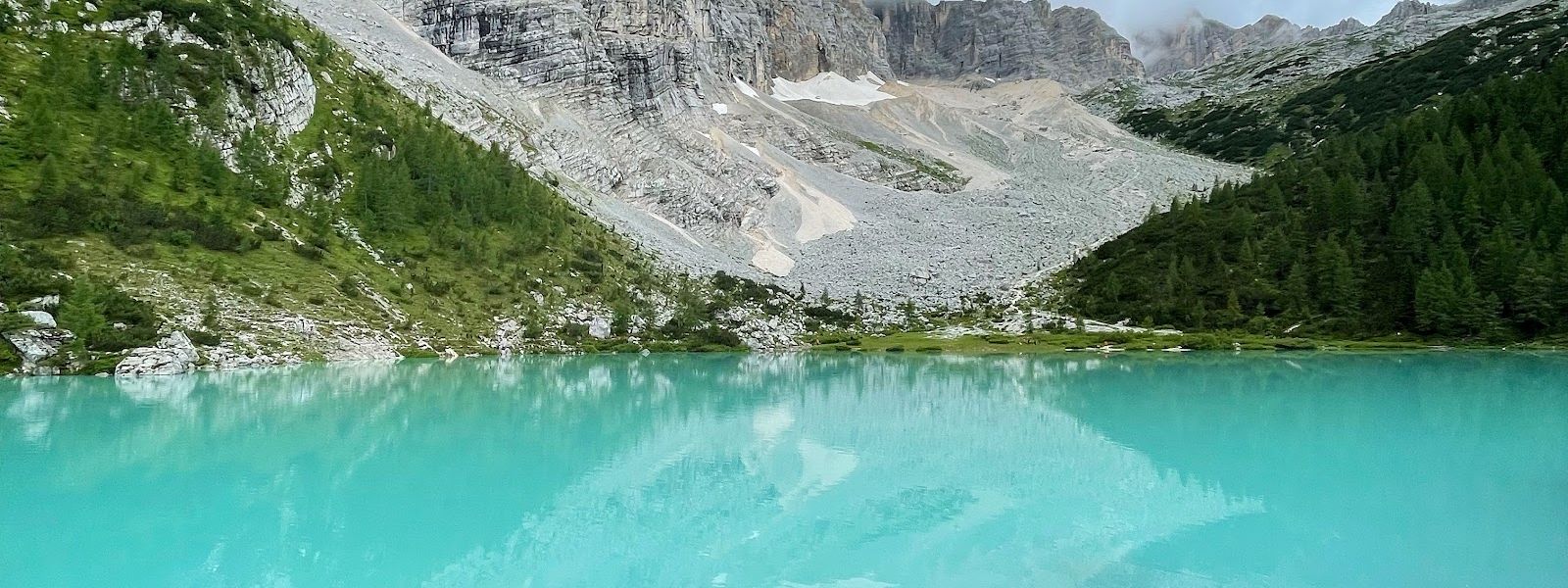
Lake Sorapis is a mountain lake in the Dolomites above Cortina d'Ampezzo, in the province of Belluno. It sits in a basin of scree under the Sorapis peaks and is known for its milky blue-green water and for the walk that reaches it: no road goes up, only waymarked mountain trails with sections secured with cable. A refuge by the shore serves food and drink. People come for the setting and for the hike itself.
Lake Sorapis
Local name: Lago di Sorapis
The stretch of trail that walkers warn each other about takes one to two minutes to cross.
- Accessibility
- Not suitable for wheelchairs or limited mobility: the lake is reached only by mountain trail, with rocky and cable-secured sections.
- Parking
- Roadside parking near the trail start, 10 euros a day (summer 2026). Mapped car parks lie about 4.2 km from the lake; one of them is free.
- Difficulty
- Trail 215: about 12 km round trip, 450 m of ascent, four hours at a relaxed pace with photo stops. Trail 217: about 600 m of height difference with some scrambling. Cable-secured and tricky sections on the way; hiking boots required.
- Transport
- Nearest mapped bus stop: Auronzo - Albergo Cristallo, about 3.5 km from the lake.
What makes it special
The water is what people walk in for: a milky blue-green held in a basin of pale scree right under the Sorapis walls. A refuge stands by the shore, and the prices in it are not steep. Getting to the water is the other half of the day. Trail 215 covers about 12 km there and back with 450 m of ascent, and a party stopping often for photographs took four hours over it; trail 217 puts about 600 m of height difference into the legs and asks for hands on rock in a few places.
Good to know
- Arrive early: in early June the roadside parking was nearly gone by half past nine.
- Wear hiking boots: parts of the trail are secured with cable and a few sections are tricky underfoot.
- Two routes in: trail 215 runs about 12 km round trip; trail 217 climbs about 600 m and involves some scrambling.
- No services near the lake: nothing is mapped for toilets or drinking water; the refuge by the shore is the only stop.
- The way down is the hard part: on trail 217 the descent asks for more care than the climb.
Getting there
No road reaches the lake. Cars stop on the roadside below, and everything after that is on foot. Two waymarked mountain trails lead up, 215 and 217, and both cross sections secured with cable. Trail 217 also involves some hands-on climbing, and that is the part people find hardest on the way back down. Whichever route you take, count the return leg into the day as well.
Best time to visit
Better: an early start.
Avoid: setting off mid-morning in summer, when the roadside parking has already filled — in early June it was nearly gone at half past nine.
An early start also puts the lake in front of you before the bulk of the day's walkers arrive, and it leaves the afternoon free for the descent, which is the leg that takes the concentration.
Sun & daylight
Nearby Places


Similar Places

Featured in our guides
Lake Sorapis on the map
Parts of the trail are secured with cable and some sections are tricky underfoot. Proper hiking boots are required, and on trail 217 the descent of about 600 m needs more care than the climb.
Get directions

Your whole travel map in one place
Get inspired by new places around the world and find the ones worth the journey
Frequently asked questions
How long is the hike to Lake Sorapis?
Trail 215 is about 12 km there and back with 450 m of ascent. At a relaxed pace with many stops for photographs it took one party four hours.Do I need proper hiking boots?
Yes. Some parts of the trail are secured with cable and a few sections are tricky underfoot, so boots with grip are the right footwear rather than trainers.Is the parking paid, and does it fill up?
The roadside parking cost 10 euros a day in summer 2026, and it goes early: at half past nine at the start of June nearly all of it was taken.Is there anywhere to eat or drink at the lake?
A refuge by the lake serves food and drink, and the prices in it are not steep. Nothing else is mapped nearby for toilets or drinking water, so carry your own.