Teide is an active stratovolcano in the centre of Tenerife, within the municipality of La Orotava. Its summit, at 3,715 m, is the highest point in Spain and in the Atlantic Ocean, and the cone rises from the floor of the Las Cañadas caldera, the remains of an older volcano. The last eruption came in 1909 from the El Chinyero vent. The mountain and its surroundings form Teide National Park, a UNESCO World Heritage Site since 2007 and the most visited national park in Spain.
Mount Teide
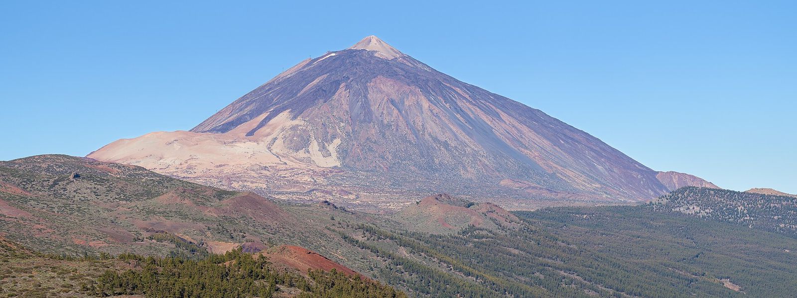
Active stratovolcano rising to 3,715 m above the Las Cañadas caldera, with a cable car most of the way up.
- Entrance
- The permit for the final 200 m to the summit is free. The cable car charges a fare.
- Accessibility
- The cable car lifts visitors to 3,555 m without a climb, but the thin air there can make people light-headed or dizzy, especially with heart or lung conditions. The way to the summit beyond is on foot.
- Parking
- Two free car parks beside the lower cable car station, about 2.5 km in a straight line below the summit; one is for customers only.
- Difficulty
- The cable car covers 2,356 m to 3,555 m in eight minutes. The last 200 m to the summit are on foot, up the steep summit cone in thin air. The footpaths from below reach the upper station entirely on foot, all of it above 2,000 m.
- Transport
- TITSA, one return service a day from Puerto de la Cruz and from Playa de las Américas; stop Teleférico del Teide.
- Advance booking
- Needed for the summit: the last 200 m require a free permit, so arrange it before the day of your visit.
- Address
- Mount Teide, 38300, Santa Cruz de Tenerife, Spain
What makes it special
At sunset the summit throws its shadow across the sea: a clean triangle more than 40 km long that reaches Gran Canaria in the evening and La Gomera at dawn. The mountain itself has no such neat outline. The perfect triangle is a trick of perspective.
At the top the air goes quiet, and the small summit cone, El Pitón, is still alive, with fumaroles in its crater giving off sulphur gases. Below, the Las Cañadas caldera spreads out as a plain of lava at around 2,000 m, and Pico Viejo's crater, 800 m across, opens on the western flank. In May and June the Teide bugloss puts up red flower spikes up to 3 m tall, higher than a person standing beside them. After dark the sky is clear and steady enough that an astronomical observatory works on the slopes.
Good to know
- Summit permit: the last 200 m to the top need a free permit, arranged before you go.
- The air at the upper cable car station is thin and can bring on dizziness, more so with heart or lung conditions.
- Temperatures swing about 15 °C over a day and winter brings snow; pack warm layers even when the coast is hot.
- The UV index at altitude passes 11 in midsummer, so cover up and use sun cream.
- There is no drinking water near the summit; carry your own.
Getting there
A single public road crosses the Las Cañadas caldera from north-east to south-west, climbing through pine forest before the trees give out and the lava fields begin. The lower cable car station stands beside that road at 2,356 m, with car parks and the Teleférico del Teide bus stop next to it, about 2.5 km in a straight line from the summit. The cabin takes eight minutes to reach the upper station at 3,555 m. From there a footpath continues to the top, and the final 200 m are open only to permit holders. Several footpaths also climb from below to the upper station, for those who want to walk the whole way.
Best time to visit
Best: late afternoon to sunset on a clear day, and May to June for the flowers. The setting sun throws Teide's shadow across the sea towards Gran Canaria, and the Teide bugloss blooms in the caldera in late spring.
Avoid: winter if you plan to walk to the summit without crampons and poles, and the middle of the day in high summer. Snow and ice lie on the upper path in winter, and the UV index at this altitude passes 11 in midsummer.
Access & restrictions
Teide and the whole Las Cañadas caldera lie inside Teide National Park, a UNESCO World Heritage Site. The final 200 m to the summit are restricted: climbing them requires a free permit, and without one the path to the top is closed to you. Keep to the marked footpaths across the park and leave rocks and plants where they are; many of the plants on these slopes grow only on Tenerife.
Sun & daylight
Nearby Places

Similar Places


Mount Teide on the map
The thin air near the summit can cause dizziness, altitude sickness and in extreme cases fainting, especially with heart or lung conditions; if you feel unwell, go back down at once. In winter, snow and ice cover the upper paths.
Get directions
Your whole travel map in one place
Get inspired by new places around the world and find the ones worth the journey
Frequently asked questions
Do I need a permit to reach the summit of Mount Teide?
Yes. The last 200 m to the summit are restricted, and climbing them requires a permit. The permit is free.How long does the Teide cable car take?
Eight minutes, from the roadside station at 2,356 m to the upper station at 3,555 m. A cabin carries up to 38 people, or 34 in a high wind.Can I get to Mount Teide by bus?
TITSA runs one return service a day to Teide from Puerto de la Cruz and from Playa de las Américas. The stop at the lower cable car station is Teleférico del Teide.Is Teide still an active volcano?
Yes. The most recent eruption was in 1909 from the El Chinyero vent on the north-west rift, and fumaroles at the summit still give off sulphur gases.When can you see the shadow of Teide?
At dawn and at sunset. At dawn the triangular shadow reaches La Gomera, and at sunset it stretches towards Gran Canaria, more than 40 km across the sea.