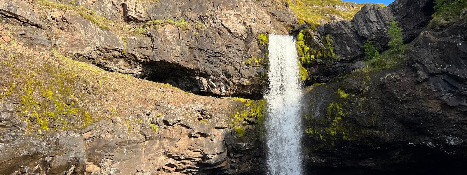
Gilsarfoss is a waterfall in East Iceland, close to the village of Fáskrúðsfjörður. It stands above the road and is hard to see from a passing car. A 4x4 track climbs 550 metres up the hill, and a sheep trail then drops 100 metres to the water. The falls can be reached from below, and there is room to walk behind them. The site is open at any hour, and the colours come out in direct sun.
- Entrance
- Free
- Accessibility
- No wheelchair-accessible entrance. The approach runs along a 4x4 track and a sheep trail, with scrambling near the water.
- Parking
- Small gravel pull-out off Rte 955; don't drive further up the track
- Difficulty
- 550 m uphill on a 4x4 track, then 100 m downhill on a sheep trail. Rough footing and some scrambling; a harder path continues to the top of the falls.
- Transport
- Self-drive; gravel Rte 955 (park low, walk in)
- Hours
- Open 24 hours, every day.
- Address
- Route 955, Fáskrúðsfjörður
What makes it special
Gilsarfoss is easy to drive straight past. The falls sit above the road and are hard to see from a car, and a marker shows where the small trail starts.
The reason to stop is how close you get. The trail drops to the foot of the falls, and there is space to walk behind the water. Spray drifts well beyond the drop, so clothes and camera get damp. A more difficult path continues up the side and onto the top of the falls.
Colour here depends on sunlight. In flat light the water and the rock go grey.
Good to know
- Finding it: the falls are hard to see from the road below. A marker shows where the small trail leaves for the water.
- The approach: 550 metres uphill on a 4x4 track, then 100 metres down a sheep trail to the falls.
- Footing: the trail is rough and involves some scrambling. Poor going for anyone unsteady on their feet.
- Spray: mist from the falls will get you wet, and more so behind the water. Protect a camera.
- Do not drive on: past the waterfall the road turns into a very dangerous rocky path.
Getting there
The last stretch is a rough track. Where the Google Maps pin stops, a small road climbs the hill towards the falls: 550 metres up on a 4x4 track, then 100 metres down a sheep trail to the water. The falls are hard to spot from the road, and a marker shows where the trail starts. If the driving turns into a broken rocky path, you have gone past the waterfall.
Best time to visit
Better: a clear day with direct sun.
Avoid: flat overcast light, if you have come to take photographs.
The colours at Gilsarfoss depend on sunlight, and without it the water and rock read grey. The site is open at any hour, so light rather than opening times decides when to come.
Sun & daylight
Nearby Places
Similar Places

Gilsarfoss on the map
Past the waterfall the road turns into a rocky path that is dangerous to drive. Stop at the falls and turn round. At the water the footing is poor and the rock is wet with spray, and the path onto the top of the falls is harder than the walk in.
Get directions

Your whole travel map in one place
Get inspired by new places around the world and find the ones worth the journey
Frequently asked questions
Can you walk behind Gilsarfoss?
Yes. The trail leads down to the foot of the falls, and there is room to pass behind the water. Expect spray.How long is the walk from the road?
550 metres uphill on a 4x4 track, then 100 metres down a sheep trail to the falls.Is Gilsarfoss hard to find?
The falls are hard to see from the road. Where the Google Maps pin stops, a small road climbs the hill, and a marker shows where the trail to the water starts.Are there opening hours?
No. The site is open 24 hours a day, every day.Is it suitable for wheelchairs or unsteady walkers?
No. There is no wheelchair-accessible entrance, and the approach has rough footing and some scrambling.