Herðubreið is a 1,682-metre tuya in the highlands of Northeast Iceland, inside Vatnajökull National Park. It stands on the eastern side of the Ódáðahraun lava desert, close to the Askja volcano. The mountain formed beneath the ice sheet of the last glacial period, which gave it its steep sides and flat top. People come to see it from the lava desert around it, and to climb the scree route to the crater on its summit plateau.
Herðubreið
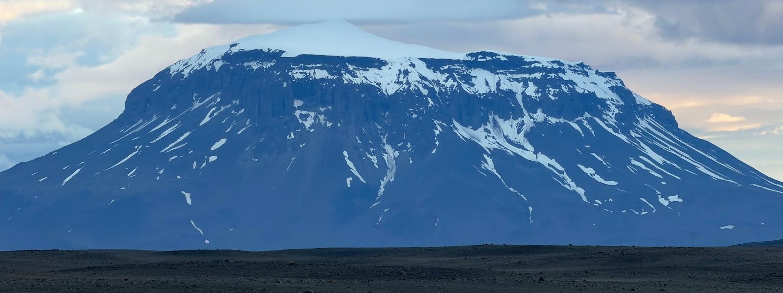
Icelanders have known the mountain by this name since at least 1300, but its sides are so steep and unstable that no one made a certain ascent until 1908.
- Entrance
- Free
- Parking
- The access road ends at the start of the walking track; vehicles go no further.
- Difficulty
- Loose scree for 30–60 minutes depending on pace, then easy walking to the plateau, apart from the final few metres.
- Transport
- 4x4 only — highland F-roads (F88 / F905–F910), summer
- Advance booking
- Summit suits experienced hikers or a guided group
- Address
- Herðubreið, 660
What makes it special
Herðubreið erupted under the ice sheet of the last glacial period, inside a meltwater lake walled by ice about 800 metres high. Those walls shaped it: a steep-sided mountain with a flat crown, standing alone above the black Ódáðahraun lava desert. Geologists call the landform a tuya, and this is the classic example of one. Icelanders call it the Queen of Icelandic Mountains, and in 2002 it was voted the country's favourite mountain.
The steep, unstable sides kept climbers off for centuries. The name has been in use since at least 1300, but the first certain ascent came in 1908, by Hans Reck and Sigurður Sumarliðason. The southern part of the summit plateau holds a deep crater, which can fill with a lake in summer.
Good to know
- Wear a helmet. The route climbs loose scree, and rock comes down from anyone above you on the slope.
- Keep 10 minutes between groups. Distance is the only protection on the scree, going up and coming down.
- Allow a full day. Official hiking time is around 8 hours in total; fast walkers manage it in about 4.
- Above the scree the walking is easy, apart from the final few metres onto the plateau.
Getting there
Herðubreið stands on the eastern side of the Ódáðahraun lava desert, and the last stretch to it is driven. The access road needs careful driving. The trailhead is not the hard part: it is obvious even on a first visit. Below the mountain lies the oasis of Herðubreiðarlindir, with a campground and hiking trails.
Best time to visit
Better: summer. Avoid: setting off late in the day.
In summer the deep crater on the summit plateau can hold a lake, with ice still melting in it, and that is what the climb is for. Herðubreið is a full-day mountain, so a morning start is the only sensible one.
Sun & daylight
Nearby Places

Similar Places


Herðubreið on the map
Rockfall is the real danger here. The ascent crosses loose scree, and parties above dislodge stones onto the route below them. Keep at least 10 minutes behind the group ahead, and wear a helmet. The sides of the mountain are steep and unstable.
Get directions

Your whole travel map in one place
Get inspired by new places around the world and find the ones worth the journey
Frequently asked questions
Where does the walking track start?
Exactly where the car road ends. The start point is easy to find, even on a first visit.What is at the top?
The southern part of the summit plateau holds a deep crater. In summer it can contain a lake, with ice still melting in it.Is Herðubreið an active volcano?
It is believed to be inactive. It sits apart from the active fissure swarms and central volcanoes around it, including the active Askja volcano nearby.Is the mountain protected?
Yes. Herðubreið became part of Vatnajökull National Park in 2019, in the northern section of the park.Who lived in the Ódáðahraun desert?
Outlaws excluded from Icelandic society for their crimes. They used the oasis of Herðubreiðarlindir; Fjalla-Eyvindur spent the winter of 1774–1775 there.