Kalfshamarsvik Lighthouse sits at the tip of a small peninsula on the coast of Northwest Iceland. The building is art deco, and it stands on a bed of columnar basalt that forms the shoreline. The same headland holds the ruins of a settlement, among them a turf hut dated 1900 to 1937, with plaques explaining who lived there. The site is remote and quiet, and a visit covers the columns, the ruins and the lighthouse on foot.
Kalfshamarsvik Lighthouse
Local name: Kálfshamarsvík
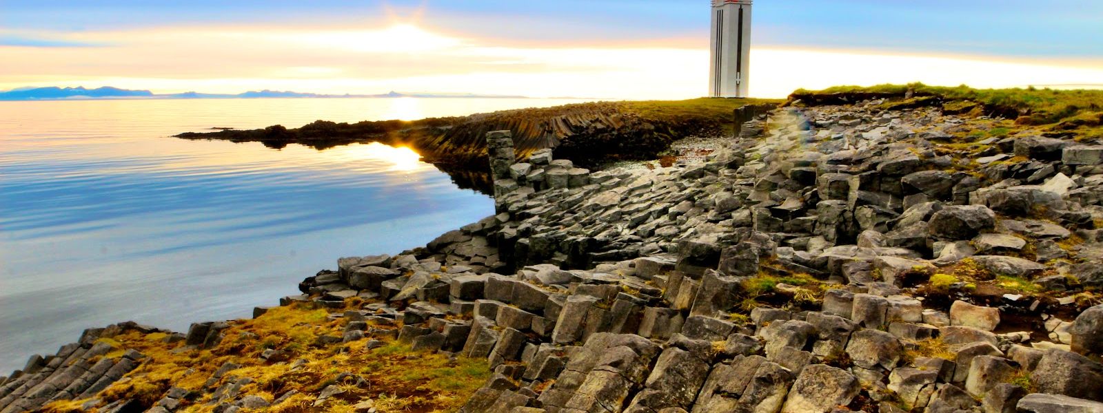
An art deco lighthouse on a headland of basalt columns, standing among the ruins of a settlement that lasted from 1900 to 1937.
- Entrance
- Free, no admission fee.
- Accessibility
- No wheelchair-accessible entrance.
- Parking
- Free car park with room for about 10 vehicles, roughly 200 m from the lighthouse.
- Difficulty
- Roughly 1–2 km of walking to cover the lighthouse, the basalt columns and the ruins.
- Hours
- Open 24 hours, every day.
- Address
- 546 Kálfshamarsvík
What makes it special
The lighthouse gets the attention, but the ground under it is the reason to come. The headland is a bed of basalt columns, and the lighthouse stands at its tip in art deco style, which is not what most Icelandic lighthouses look like. Behind it lie the ruins of a settlement, including a turf hut that stood between 1900 and 1937. Plaques around the site name the people who tried to live at this wind-lashed spot, and the ruins are quiet enough to walk past without noticing them. Across the fjord, when the air is clear, the sharp peaks of the east coast of the West Fjords rise on the horizon.
Good to know
- Wind: The headland is fully exposed, and wind is what makes a visit hard work. Check the forecast before the drive.
- Allow time: The lighthouse, the columns and the ruins are spread along the headland, and a quick stop covers only part of it.
- Toilets: There is a toilet building at the car park.
- Supplies: No drinking water and no information point nearby. Bring what you need.
Getting there
No bus serves Kalfshamarsvik, so the approach is by car. The last 20 km run on gravel, and that stretch is kept in good order. From the car park the rest is on foot: the lighthouse, the basalt columns and the ruins are strung out along the headland, so the visit is a walk rather than a stop at a viewpoint.
Best time to visit
Better: summer for birds and wildlife, winter for reading the layout of the ruined settlement. Avoid: days with strong wind.
The bay holds up in either season, and the basalt formations look much the same year round. What changes is what stands out. In winter the outline of the ruins is clearer. In summer there are more birds and more wildlife generally. Wind is the one thing that spoils a visit here.
Sun & daylight
Nearby Places


Similar Places



Kalfshamarsvik Lighthouse on the map
The headland is fully exposed to the wind. Sustained 50 km/h with stronger gusts was recorded here in late May, enough to drag 9°C down to feeling close to freezing and to make walking difficult. Dress for it and take the wind into account before heading out along the columns.
Get directions

Your whole travel map in one place
Get inspired by new places around the world and find the ones worth the journey
Frequently asked questions
What is there to see besides the lighthouse?
The headland itself is a bed of basalt columns. Around the site stand the ruins of a settlement, including a turf hut from the years 1900 to 1937, with plaques explaining who lived here.What is the road like?
The last 20 km are gravel. That section is well maintained.Are there toilets?
Yes. There is a toilet building at the car park.Is it worth coming in winter?
Yes. In winter the layout of the ruined settlement stands out more clearly, while summer brings more birds and wildlife. The basalt formations look much the same in both seasons.Can the West Fjords be seen from here?
When visibility is good, the sharp peaks of the east coast of the West Fjords are visible across the fjord.