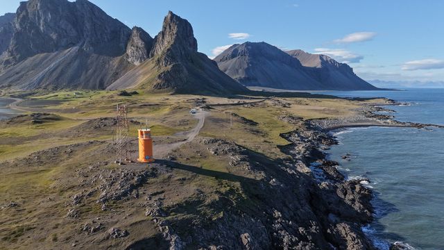
Krossanesfjall is a 716-metre mountain on the coast of South Iceland, in the municipality of Hornafjörður. Many visitors know it by the name Eystrahorn. Dark, steep rock rises straight from a shore of black sand, and the whole ridge is in view from the road between the south coast and the east fjords. A lighthouse stands below it. Most people stop on the drive, photograph the mountain from the beach and carry on.
Krossanesfjall Mountain
Local name: Krossanesfjall

The map calls it Krossanesfjall, and most photographs of it are captioned Eystrahorn: the same 716 metres of dark gabbro above the same black sand.
- Entrance
- Free. This is open coast, with no ticket.
- Accessibility
- Partial — roadside views; beach on foot
- Parking
- Free car park at the lighthouse below the mountain.
- Difficulty
- No hike involved: the viewpoint is at the car park, and the walk along the black sand beach is flat.
- Transport
- Self-drive — Ring Road near Hvalnes
- Hours
- Open at all hours, all year.
- Address
- Krossanesfjall, 781
What makes it special
Two names, one mountain. The map says Krossanesfjall, and most photographs of it are captioned Eystrahorn. It stands 716 metres above a shore of black sand, and the whole ridge is in view from the road, so nothing has to be walked into.
The rock is gabbro and granophyre, dark and coarse-grained, and the peaks read almost black against the sea. Fog rolls in off the water and over the hills, and it can take the summit away completely. The beach below is worth the walk on its own. Tour coaches stop here, and the place still does not feel busy.
Good to know
- Arctic terns: they nest near the shore in summer and dive at heads. Hold a hand or a stick above you and keep walking.
- Fog: cloud rolls in off the sea and over the hills, and it can hide the mountain from the road entirely.
- Wind: this is open coast. A windproof layer matters more here than a warm one.
- Coaches: tour buses pull in at the lighthouse. Even then the site does not feel crowded.
Getting there
Krossanesfjall stands beside the coast road between the south coast and the east fjords, and most people meet it as a stop on that drive. There is a car park at the lighthouse below the mountain. The viewpoint is the car park itself: no walk in and no climb to see the mountain. From there a flat walk leads along the black sand beach under the rock face.
Best time to visit
Better: a clear day, and the hours of low sun at either end of it, when the rock face takes on relief.
Avoid: low cloud. Fog off the sea can take the whole mountain out of the picture, and there is nothing else here to fall back on except the beach.
The view is the entire reason to stop, so the weather decides whether the stop is worth making. In summer the shore belongs to nesting arctic terns.
Sun & daylight
Nearby Places


Similar Places


Krossanesfjall Mountain on the map
Arctic terns nest near the shore in summer and attack anyone who comes close, striking at the head. Raise a hand, a stick or a tripod above you, keep moving and do not stop beside the nests.
Get directions

Your whole travel map in one place
Get inspired by new places around the world and find the ones worth the journey
Frequently asked questions
Is Krossanesfjall the same mountain as Eystrahorn?
Yes. Krossanesfjall is the name on the map, and Eystrahorn is what most visitors and photographers call it.Do you have to hike to see the mountain?
No. Access is easy: the mountain is in full view from the car park at the lighthouse, and the walk along the black beach below it is flat.Is there anything dangerous here?
In summer, arctic terns nest near the shore and dive at people who come near. Keep a hand or a stick raised above your head and walk on without stopping.Is it worth stopping in bad weather?
Fog rolls over the hills and can hide the mountain completely, and the view is the whole point of the stop. The walk along the black beach still works in cloud.Can the mountain be photographed by drone?
It is shot both from the ground and from the air. In summer, give the nesting terns along the shore a wide berth.