Kleifarvatn is the largest lake on the Reykjanes Peninsula in Iceland, in the southern part of the peninsula. It lies on the fissure zone of the Mid-Atlantic Ridge and has no visible inflow or outflow: most of its water arrives and leaves underground. The lake was first surveyed in 1964. Hiking trails and a small fishing lodge sit by the water, and a viewpoint looks across to the mountains on the far shore. It is a short drive from Reykjavík.
Lake Kleifarvatn
Local name: Kleifarvatn
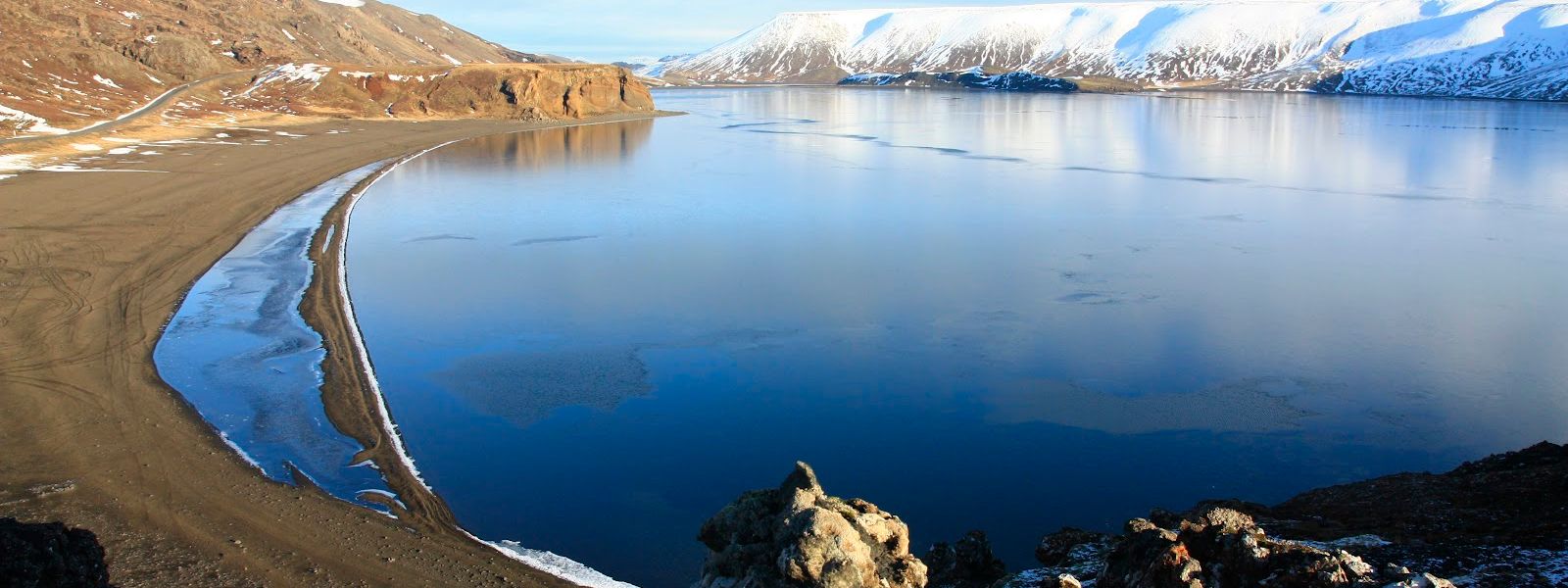
After the earthquakes of 2000 the lake began to shrink, and at least a fifth of its surface has gone since.
- Difficulty
- Easy — roadside viewpoints and shore walks
- Transport
- Self-drive — the road runs along the west shore
- Address
- Kleifarvatn, 241
What makes it special
Kleifarvatn sits on the fissure zone of the Mid-Atlantic Ridge, and the geology shows in the water rather than in the rock. No river runs in and none runs out. Most of the water arrives and leaves underground. A survey in 2012 confirmed one geothermal vent on the lake bed and pointed to two more, lined up along the faults that run through the area.
From the viewpoint the far shore is a line of mountains, and on a clear morning the whole lake is in view. Other stops lie in the same part of the peninsula: Grænavatn, Eldborg and Krýsuvíkurkirkja.
Good to know
- Winter driving: the drive out to the lake is tricky in winter.
- On site: hiking trails run from the lake, and there is a small fishing lodge.
- Nearby geothermal ground: two high-temperature areas lie close by — Seltún/Krýsuvík and another one to the east.
- Ice: in winter parts of the lake freeze, though not the whole surface.
Getting there
Kleifarvatn is reached by car, and the last stretch in to the water is a track. There is a viewpoint over the lake, with the mountains of the far shore in the frame. The lake also works as a stop on a longer loop: from the Blue Lagoon, drive south, then along the coast, and pass the lake on the way back north to Reykjavík.
Best time to visit
Best: a clear morning, when the lake and the mountains on the opposite side are both in view. A dark night, if the aurora is the reason for coming.
Avoid: summer nights for aurora watching — there is no real darkness then.
The area around the lake is dark at night, and that darkness is what makes it a popular aurora spot. Colour and light over the lake change through the year, so a second visit in another season does not repeat the first.
Sun & daylight
Nearby Places


Similar Places



Lake Kleifarvatn on the map
The lakeside road gets icy and treacherous in winter — check conditions on road.is before driving out.
Get directions

Your whole travel map in one place
Get inspired by new places around the world and find the ones worth the journey
Frequently asked questions
How deep is Kleifarvatn?
The greatest recorded depth was 97 m in 1975. By 2012 the deepest point measured 89.5 m and the lake covered 7.36 km²; earlier measurements put its area between 7.5 and 10 km².Do any rivers run into the lake?
No. Kleifarvatn has no visible inflow or outflow, and most of its water arrives and leaves underground. A 2012 survey also found a geothermal vent beneath the lake.Is there anything to do at the lake?
Hiking trails run from the lake and there is a small fishing lodge. A viewpoint above the water looks across to the mountains on the far shore.Is the lake connected with a book?
Yes. The novel Kleifarvatn by the Icelandic writer Arnaldur Indriðason is named after the lake.What else is worth stopping for nearby?
The Seltún/Krýsuvík geothermal field and a second high-temperature area east of the lake. Grænavatn, Eldborg and Krýsuvíkurkirkja are in the same part of the peninsula.