Svalvogaviti stands on the shore at the outer end of the Svalvogar peninsula, in the Westfjords of Iceland. The lighthouse is small, and most people come for the way in rather than for the building. Road 622 runs out from Þingeyri and becomes roughly 20 km of dirt track along the mountainside, with small unbridged rivers to cross. A 4x4 is needed. Arctic foxes and birds are common along the northern half.
Svalvogaviti Lighthouse
Local name: Svalvogaviti
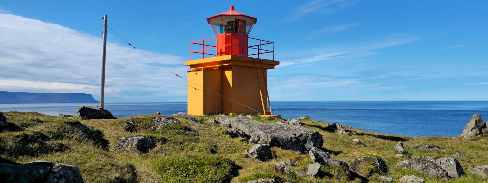
The road is the attraction: about 20 km of dirt track cut into the mountainside, with unbridged rivers to cross, ending at a small lighthouse on the shore.
- Entrance
- Free. No gate and no ticket.
- Accessibility
- The only access is a rough dirt track with unbridged river crossings. Not usable with a wheelchair.
- Parking
- Roadside, limited
- Difficulty
- The hard part is the drive, not a walk: about 20 km of unpaved track, unbridged stream crossings and an exposed mountainside section. 4x4 required.
- Transport
- 4×4 only (Svalvogar road, Route 622)
- Hours
- Open 24 hours.
- Address
- Svalvogar, 471 Þingeyri
What makes it special
The lighthouse is small and stands right at the water's edge, at the outer end of the Svalvogar peninsula. Almost everyone who gets here rates the drive above the building. Road 622 runs out from Þingeyri and cuts roughly 20 km of dirt track across the mountainside, with small rivers to ford and no bridges over them. The track is known as Kjaran's avenue, after the man who cut it into the cliffs with a bulldozer. Arctic foxes cross the northern half and birds are thick on the slopes above it. The place feels remote, and that is most of what people come for.
Good to know
- 4x4 only. Roughly 20 km of dirt track, and the small rivers across it are not bridged.
- Landslides. The northern section runs along an open mountainside. Rock comes down during and after rain.
- Come for the road. The lighthouse is small; the drive is what the trip is about.
- Wildlife on the track. Arctic foxes cross the northern half, and birds sit on the slopes above it.
Getting there
Driving is how people get here. Road 622 leaves Þingeyri and runs out along the coast, and the last stretch is roughly 20 km of dirt cutting across the fjord side. Small rivers cross the track and none of them are bridged. A 4x4 is needed. With one you can drive the full Svalvogar circle instead of turning back the way you came. The northern approach is the more interesting half, and it is also the section with the loose slope above it.
Best time to visit
Better: dry weather and dry ground.
Avoid: during rain and straight after it.
The northern section runs along an open mountainside that sheds rock, and rain is when it moves. Wet ground on its own is not a stopper: the track has been driven in light rain in a 4x4 without trouble. Heavy or steady rain is a different matter, and the hazard is above you rather than under your wheels.
Sun & daylight
Nearby Places


Similar Places


Svalvogaviti Lighthouse on the map
The northern section of the road is cut into the mountainside and is exposed to landslides. The risk is highest during rain and after it. The small rivers that cross the track are unbridged and rise with rainfall. Do not attempt the route without a 4x4.
Get directions

Your whole travel map in one place
Get inspired by new places around the world and find the ones worth the journey
Frequently asked questions
Do you need a 4x4 to reach Svalvogaviti?
Yes. The last stretch is roughly 20 km of dirt track, and the small rivers that cross it are not bridged.Which way should you approach?
Road 622 from Þingeyri. The northern half is the more interesting one, and with a 4x4 you can drive the whole Svalvogar circle rather than returning the same way.Is the lighthouse itself worth the drive?
The lighthouse is small, and the road is what people rate higher. Come for the drive and treat the lighthouse as the turning point.What is the main hazard on the way?
Landslides on the northern section, where the road runs along the mountainside. The risk is highest during and after rain.