Þorbjörn is a 243 m volcanic mountain near the tip of the Reykjanes peninsula in Iceland, between the town of Grindavík and the Svartsengi power station with the Blue Lagoon. It formed under ice during the Pleistocene and is treated as a symbol of Reykjanes geology. Hiking trails lead onto it, and the summit looks out over the lagoon, the town and the lava of the recent eruptions. The area is volcanically active, and access has been closed when eruptions broke out nearby.
Mount Þorbjörn
Local name: Þorbjörn
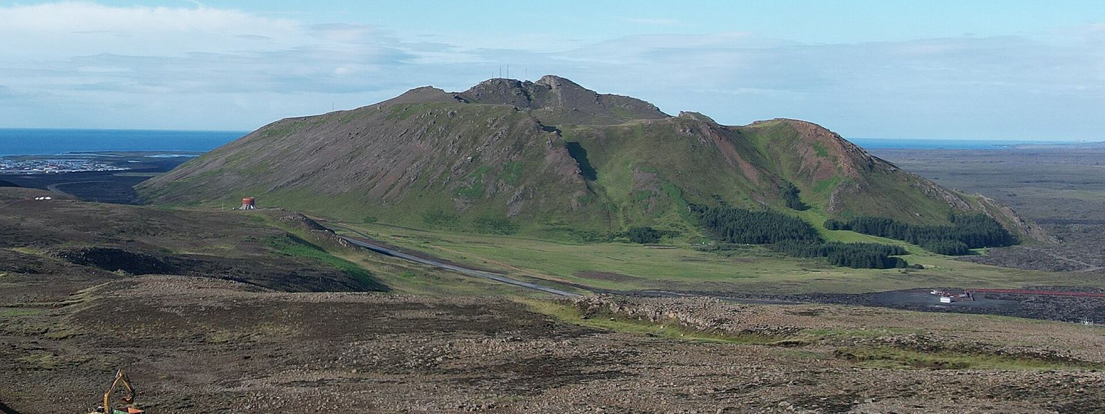
The canyon at the top is called Þjófagjá, Thieves' Canyon. A farmer's son joined a band of raiders to find their hiding place, a cave inside the mountain, and they were captured and hanged.
- Difficulty
- Two routes to the 243 m summit: a longer, gentler way around the mountain and a shorter, steeper climb. Up and back takes about two hours. Manageable without mountain experience.
What makes it special
From the 243 m summit the Blue Lagoon and the Svartsengi power station sit almost directly below. Grindavík lies on the coast beyond, largely emptied since the eruptions of the past few years, and dark lava covers the ground around it. In good visibility Reykjavík and the open ocean come into view as well. The top is not empty ground. Masts of the telephone company Sími and the broadcaster RÚV stand where the US Navy kept radar stations, and the jeep track the US Army cut up the slope during the Second World War is still there.
Good to know
- Closures: eruptions close by have led to access to the mountain being blocked. Check the current situation before you drive out.
- The summit is not wild: transmitter masts stand on top, and an old jeep track runs up the slope to reach them.
- Picnic: there is greenery at the foot of the mountain, scarce elsewhere on this stretch, and in fair weather it is somewhere to eat outdoors.
Getting there
Þorbjörn stands between Grindavík and the Svartsengi power station with the Blue Lagoon. Road 43 runs past it to the east, and route 426 loops around the western side between the town and Svartsengi. The last stretch is on foot. Trails lead up onto the mountain, one of them from the south-west, and the wartime jeep track climbs all the way to the top.
Best time to visit
Better: a clear day. The point of the climb is the view — the Blue Lagoon below, the lava around Grindavík, and Reykjavík and the ocean when visibility is good.
Avoid: low cloud, and any period when volcanic activity nearby has the mountain closed off.
Sun & daylight
Nearby Places


Similar Places


Mount Þorbjörn on the map
Þorbjörn sits in an active volcanic zone. Ground uplift and earthquake swarms have been measured around the mountain since 2020, eruptions have broken out close by, and access has been blocked because of them. The Icelandic Met Office monitors the ground here; check the current situation before you set out.
Get directions

Your whole travel map in one place
Get inspired by new places around the world and find the ones worth the journey
Frequently asked questions
How was Þorbjörn formed?
It grew from a subglacial eruption during a cold spell in the Pleistocene, building up under ice as a flat-topped tuya. Faults and a graben cross the mountain, but geologists trace it to a single eruption. A tectonic graben runs over the top and cuts a canyon up to 80 m deep, and an eroded crater sits in the upper part.Why are there masts on the summit?
The US Navy had radar stations there. They passed to the Icelandic Government when the Navy left the country in 2006, and transmitters of the telephone company Sími and the broadcaster RÚV now occupy the site. The track up the mountain was built by the US Army during the Second World War.What does the name mean?
Þorbjörn is a common man's name in Iceland. The mountain is also called Þorbjarnarfell, the mountain of Þorbjörn, after the son of a farmer in the district.Can you see the Blue Lagoon from the top?
Yes. Þorbjörn is the closest mountain to the lagoon, and both the lagoon and the Svartsengi power station lie below the summit. In good visibility Reykjavík and the ocean are visible as well.