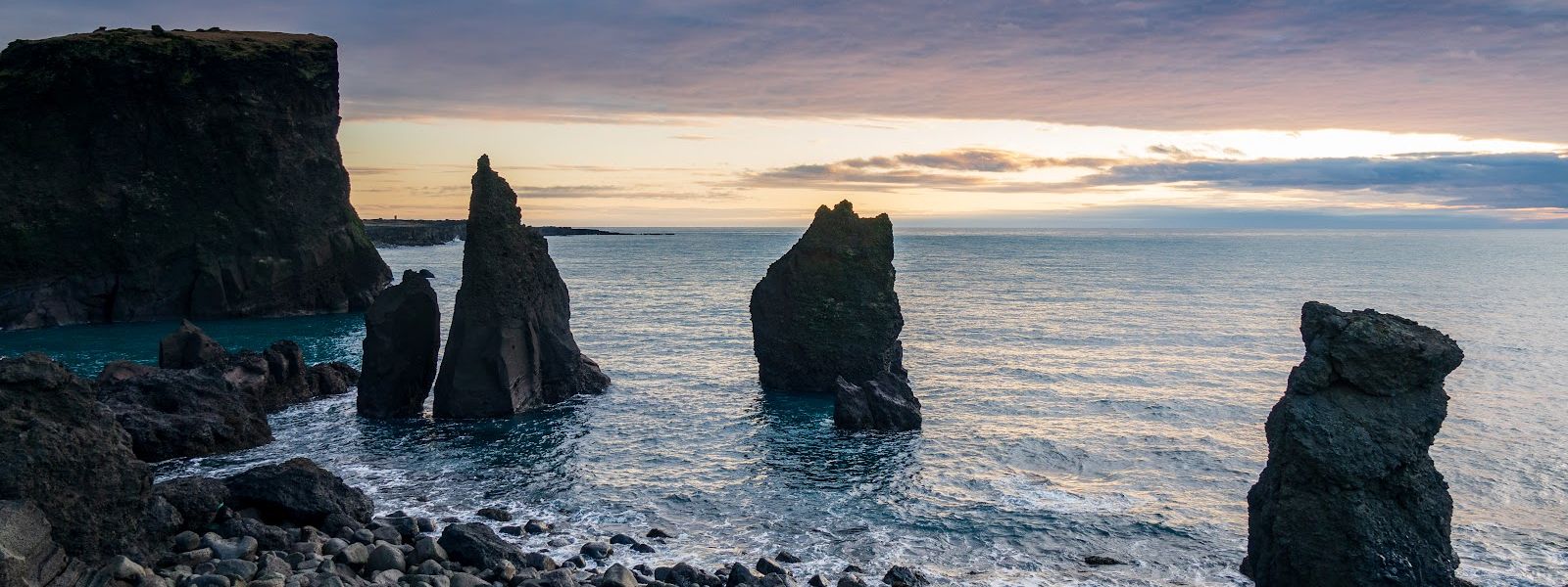
Valahnukamol is a stretch of boulder shore and sea cliffs at the tip of the Reykjanes Peninsula in Iceland, beside the Reykjanesviti lighthouse. The shoreline is made of large rounded stones rather than sand. Basalt sea stacks stand offshore, among them Karlinn, which rises 60 metres out of the water. Seabirds nest along the cliffs and whales are sometimes seen from the shore. A bronze statue of the Great Auk faces Eldey, the island where the species was last recorded. The point is open at all hours and reached by car.
Valahnukamol Coast
Local name: Valahnúkamöl
A bronze Great Auk stands on this shore, facing Eldey — the island where the last of the species was seen.
- Parking
- Two car parks, both charged: one about 50 metres from the point, the other about 470 metres back. The road to the nearer one is rough.
- Difficulty
- 10–15 minutes downhill on foot from the lighthouse car park; the shore itself is large rounded boulders.
- Transport
- No bus stop within 5 km; access is by car.
- Hours
- Open 24 hours, every day.
What makes it special
The shore here is not sand but boulders: large rounded stones, worked smooth by North Atlantic storms. Behind them the cliffs drop straight into the water. The swell hits the base hard enough to be felt through the ground.
Offshore stands Karlinn, a sea stack rising 60 metres out of the ocean, one of several dark basalt pillars off the point. Seabirds work the cliff faces along the whole coast, and whales are sometimes seen from the shore. A bronze statue of the Great Auk faces Eldey, the island where the species was last recorded.
This is the far tip of the Reykjanes Peninsula, past the main stops on the tourist route, and it stays wilder and less crowded for it.
Good to know
- Wind: the wind off the water is cold. Bring a windproof layer whatever the forecast says.
- The cliff edge: signs warn that the ground near the drop is weakened. Keep back and photograph from a distance.
- Facilities: the nearest toilets are about 640 metres from the point, and there is no drinking water nearby.
- Bring binoculars: seabirds work the cliffs, and whales are sometimes visible offshore.
Getting there
The point is reached by car; no bus stop lies within 5 km. One car park sits close to the shore, but the road down to it is rough and bumpy. The alternative is to leave the car up by the Reykjanesviti lighthouse and walk down, which takes 10–15 minutes. An information board stands at the point itself.
Best time to visit
Better: late in the day. This is the western tip of the peninsula, the light comes in low off the open ocean, and the surf shows up white against the dark basalt at sunset.
Avoid: the edge on windy days. The ground near the drop is signposted as weakened, and there is nothing between you and the water.
The point lies beyond the main stops on the Reykjanes route, so it stays quieter than they do.
Sun & daylight
Nearby Places


Similar Places



Valahnukamol Coast on the map
The cliffs drop straight into the sea and the edge is eroding; signs warn that the surface is weakened. Stay well back from the drop and take your photographs from a distance.
Get directions

Your whole travel map in one place
Get inspired by new places around the world and find the ones worth the journey
Frequently asked questions
Can you drive right down to the cliffs?
There is a car park close to the shore, but the road down to it is rough and bumpy. The alternative is to park by the lighthouse and walk down in 10–15 minutes.Is parking free?
No. Both car parks serving the point are charged.Can you get there by public transport?
No. There is no bus stop within 5 km of the point, so the trip is made by car.Are there toilets?
The nearest toilets are about 640 metres from the point. There is no drinking water nearby.What is there to see from the shore?
Basalt sea stacks, including Karlinn at 60 metres, seabirds along the cliffs and a bronze statue of the Great Auk facing Eldey. Whales are sometimes seen offshore.