Vesturdalur is a valley on the west side of the Jökulsá á Fjöllum canyon in Northeast Iceland, inside Vatnajökull National Park. It is known for two features reached on foot from the same car park: the black basalt formations of Hljóðaklettar and the red crater hills of Rauðhólar. A 2 km loop covers the first, and a 5 km loop takes in both. The valley also has a campsite, and the drive in from Ásbyrgi is paved.
Vesturdalur Valley
Local name: Vesturdalur
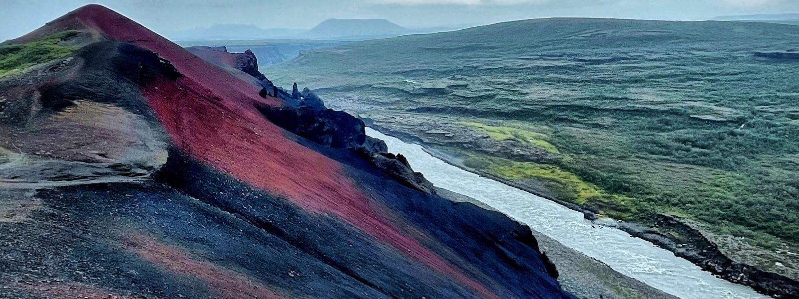
The basalt at Hljóðaklettar is the eroded root of craters that once sat in the river bed, so the columns fan and curl instead of standing straight.
- Parking
- Free. Two parking areas by the trailhead; the road in is paved all the way to the car park.
- Difficulty
- Two marked loops from the car park: 2 km to Hljóðaklettar, 5 km to Rauðhólar. Moderate, with a steep stretch near the top of the longer loop.
- Transport
- No public transport to the valley — access is by car.
- Address
- Vesturdalur, 671, Iceland
What makes it special
Two sets of rock give the valley its shape. Hljóðaklettar is a group of black basalt formations down by the river, with hollows and free-standing pillars among them. Rauðhólar, further in, is a ridge of red and rust-coloured crater remains, and the view from the top is what the longer walk is for. Between them the trail crosses a patch of low birch woodland, which is rare enough in this part of Iceland to be worth noticing. In autumn the birch and the ground cover turn, and the red hills sit against yellow scrub. The paths are marked and the geology is signed at the trailhead.
Good to know
- Toilets — there are toilets at the trailhead, along with information boards on the geology.
- No drinking water — there is no tap in the valley. Bring what you need for the loops.
- Flood closures — in August 2022 a section of trail was shut over the risk of flooding, with alternative routes to all the rock formations.
- Camping — there is a campsite in the valley.
Getting there
Vesturdalur lies on road 862, roughly 15 km south of the Ásbyrgi visitor centre. The road is paved as far as the car park, and an ordinary car manages the drive. Coming up from the Dettifoss side is the harder approach and calls for four-wheel drive. From the car park everything is on foot: a 2 km loop round Hljóðaklettar, or the 5 km loop that carries on up to Rauðhólar.
Best time to visit
Better: autumn, when the birch scrub and ground cover turn colour and the red hills stand out against them.
Avoid: wet spells, when parts of the trail network close over the risk of flooding and the marked detours add distance.
This is a walking stop rather than a viewpoint you drive to. Leave enough daylight for the full 5 km loop, which climbs steeply towards the end.
Sun & daylight
Nearby Places


Similar Places

Vesturdalur Valley on the map
Sections of the trail are closed when the river may flood them. The closures are signed and there are marked alternatives to every rock formation, so do not step around a barrier to save distance.
Get directions

Your whole travel map in one place
Get inspired by new places around the world and find the ones worth the journey
Frequently asked questions
How long are the walks at Vesturdalur?
Two marked loops start at the car park: 2 km round Hljóðaklettar, and 5 km to Rauðhólar, which takes in Hljóðaklettar on the way. The final stretch up to Rauðhólar is steep.Can you get there in an ordinary car?
Yes, coming from the Ásbyrgi visitor centre on road 862, which is paved to the parking area. The approach from the Dettifoss side is rougher and needs four-wheel drive.Are there toilets and drinking water?
There are toilets at the trailhead. There is no drinking water point, so carry your own.Does the trail ever close?
Yes. In August 2022 one section was closed over the risk of flooding. Signed alternative routes still reached all the geological features.