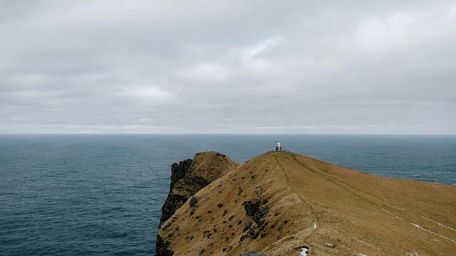
Fontur is the outer tip of Langanes, a peninsula that reaches 45 kilometres into the sea in northeast Iceland. A lighthouse, Langanesviti, stands on the narrow strip of land at the end, with Þistilfjörður on one side and Bakkaflói on the other. The cliffs along the peninsula are a major seabird coast, and the settlements on it were abandoned during the 20th century. The road out is rough. People come for the emptiness and the birds rather than for the tower.
Fontur Lighthouse
Local name: Fontur

The cliffs of Langanes hold the third largest gannet nesting place in the world, at Stórkarl.
- Accessibility
- The entrance is not wheelchair accessible.
- Hours
- Open 24 hours.
- Address
- Langanes, 681 Iceland
What makes it special
Langanes runs 45 kilometres northeast into the sea, and Fontur is the thin strip of land at the very end. The lighthouse standing there is called Langanesviti. The tower itself is plain; what people drive out for is the position, with open water on both sides and nothing beyond but sea. It is exposed and windy.
The coast behind it is empty, and it was not always. Skálar, a fishing village on the southeast side near the tip, held more than a hundred people in the early 20th century and was abandoned by 1946. Other farms and hamlets on the peninsula went the same way. Seals are sometimes seen in the water below.
Good to know
- Vehicle: the track out to the point is rough and bumpy. Take an off-road vehicle; in rain a small car can get stuck.
- Wind: the point is exposed on both sides and windy. Bring a windproof jacket, summer included.
- Old radar station: the abandoned buildings on Heiðarfjall are hard to reach and falling apart, most of them without windows.
Getting there
Fontur is reached by car, and the drive is most of the visit. The last stretch out to the point is a rough, bumpy track, and rain is what turns it into a problem for a small car. Along the way the road passes abandoned fishing villages, a viewing platform over the coast, and a beach with whale skeletons on it. Þórshöfn, on the northwest coast of the peninsula, holds almost all of the local population and has a small airport.
Best time to visit
Best: May and June. Guillemot and kittiwake are on their eggs in the cliffs then, and the peninsula is at its liveliest with birds.
Avoid: wet weather. The track out to the point gets soft in rain, and that is what strands small cars.
Fontur is quiet in any season. Even in high summer the point can be empty of people, which is most of the reason to come.
Sun & daylight
Nearby Places


Similar Places

Fontur Lighthouse on the map
The land at Fontur ends in cliffs, and the wind at the point is strong. Stay well back from the edge and keep hold of children near it.
Get directions

Your whole travel map in one place
Get inspired by new places around the world and find the ones worth the journey
Frequently asked questions
Is Fontur the same thing as Langanesviti?
Fontur is the narrow strip of land at the end of the Langanes peninsula. The lighthouse that stands on it is called Langanesviti.Can you go inside the lighthouse?
One visitor found it open and signed the visitors' book kept inside. Treat an open door as luck rather than a certainty.What else is worth stopping for on Langanes?
Abandoned fishing villages along the coast, among them Skálar, deserted since 1946. There is also a viewing platform on the way to the point and whale skeletons on the beach. Near Þórshöfn, the old church at Sauðanes is now a museum.What is the landscape of the peninsula like?
Langanes is built of late Pliocene and early Pleistocene lavas. Inland the ground rises to 200–450 metres, with Gunnólfsvíkurfjall at 719 metres the highest point. Kistufjall, 444 metres, is a table mountain formed by eruptions under ice.