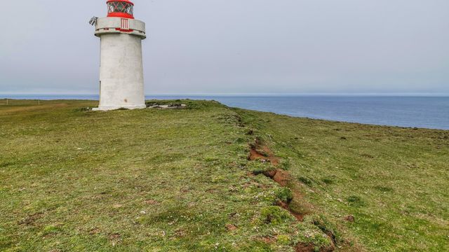
Langanes is a peninsula in north-east Iceland, 45 kilometres long, between Þistilfjörður and Bakkaflói. Inland it rises to 200–450 metres, with Gunnólfsvíkurfjall the highest point at 719 metres. It is known for its bird cliffs, including the third largest gannet nesting site in the world at Stórkarl, and for what people left behind: the fishing village of Skálar, abandoned by 1946, and a Cold War radar station on Heiðarfjall. A gravel road runs to Fontur at the tip, where the Langanesviti lighthouse stands.
Langanes Peninsula
Local name: Langanes

Stórkarl, on the cliffs of Langanes, is the third largest gannet nesting site in the world.
- Entrance
- Free
- Accessibility
- Not accessible — rough gravel, exposed unfenced cliffs
- Parking
- Roadside pull-offs at the viewpoints and trailheads
- Difficulty
- Gravel roads, rough in places. A track along the west coast leads to a high point with a birdwatching platform.
- Transport
- Self-drive — Route 869 from Þórshöfn; 4x4 advised for Fontur
- Address
- Langanes, 681 Þórshöfn
What makes it special
Langanes runs 45 kilometres to the north-east and ends in a thin spit called Fontur, marked by the Langanesviti lighthouse. Almost all of it is empty. Skálar, a fishing village on the south-east coast, had more than a hundred residents in the early 20th century and was abandoned by 1946. Heiðarhöfn, Skoruvík, Fagranes, Læknistaðir and Saurbær went the same way. On Heiðarfjall stand the remains of a NATO radar station that monitored Soviet activity in the GIUK gap between 1954 and 1968.
The cliffs are the other reason to drive out. Guillemot and kittiwake nest in them, and Stórkarl holds the third largest gannet nesting site in the world. Huts and a viewing platform along the west coast are built for watching birds.
Good to know
- Road: The route from Þórshöfn out to Fontur is gravel. One driver found it too rough and turned back.
- Only village: Þórshöfn on the north-west coast holds virtually the whole population. Everything further out is abandoned.
- Ruins: The old radar station on Heiðarfjall is derelict and hard to reach. Most of the buildings have lost their windows.
- Weather: Both coasts are open sea. Come on a clear day with little wind — that is when the cliffs are worth the drive.
- Birds: Guillemot and kittiwake lay their eggs in the cliffs in May and June.
Getting there
Þórshöfn, on the north-west coast, is the way in. It is the one inhabited village on the peninsula and it has a small airport. From there a gravel road runs out along Langanes to Fontur at the tip. The surface is rough: one visitor gave the place one star and turned back before reaching the end. A track follows the west coast to a high point where a birdwatching platform has been installed, and huts for watching birds stand along the same coast.
Best time to visit
Better: May and June, on a clear day with little wind.
Avoid: windy days with low cloud, when the cliffs give you nothing.
Guillemot and kittiwake lay their eggs in the cliffs in May and June, and egg-gatherers sometimes work the ledges then. The gannets at Stórkarl are the other reason to time a visit for the nesting season.
Sun & daylight
Nearby Places



Similar Places

Langanes Peninsula on the map
The abandoned radar station on Heiðarfjall is not a ruin to walk into. The buildings have stood open to the weather since 1968, most of them without windows, and they are difficult to reach in the first place. The bird cliffs drop straight to the sea — stay back from the edge.
Get directions

Your whole travel map in one place
Get inspired by new places around the world and find the ones worth the journey
Frequently asked questions
What is there to see on Langanes?
Bird cliffs, with huts and a platform for watching them along the west coast. At the tip, Fontur and the Langanesviti lighthouse. Along the way, the abandoned fishing village of Skálar and the derelict NATO radar station on Heiðarfjall.Is the road to the tip surfaced?
No. The road from Þórshöfn out to Fontur is gravel and rough. One visitor turned back rather than finish the drive.When do the seabirds nest?
Guillemot and kittiwake lay their eggs in the cliffs in May and June. Egg-gatherers sometimes work the cliffs at that time. Gannets nest at Stórkarl.Does anyone live on the peninsula?
Þórshöfn on the north-west coast holds virtually the whole population of Langanesbyggð municipality, which counted 480 people in 2008. Skálar, Heiðarhöfn, Læknistaðir, Skoruvík, Fagranes and Saurbær are all abandoned.What are the radar stations on the mountains?
There are two. NATO station H-2 on Heiðarfjall ran from 1954 to 1968, monitoring Soviet activity in the GIUK gap, and is now derelict. A newer station on Gunnólfsvíkurfjall, 15 kilometres south, is part of the Iceland Air Defence System.