Akureyri View Point is a scenic pull-in on the approach to Akureyri, in Northeast Iceland. It looks over the town, the fjord Eyjafjörður and the mountains that ring it. Akureyri stands at the head of the fjord, on its west side, and is the largest town in Iceland outside the Capital Region, with about 20,000 residents and an ice-free harbour. There is no path here and nothing to do but look. It is a photo stop, not a place to spend time.
Akureyri View Point
Local name: Útsýnisstaður
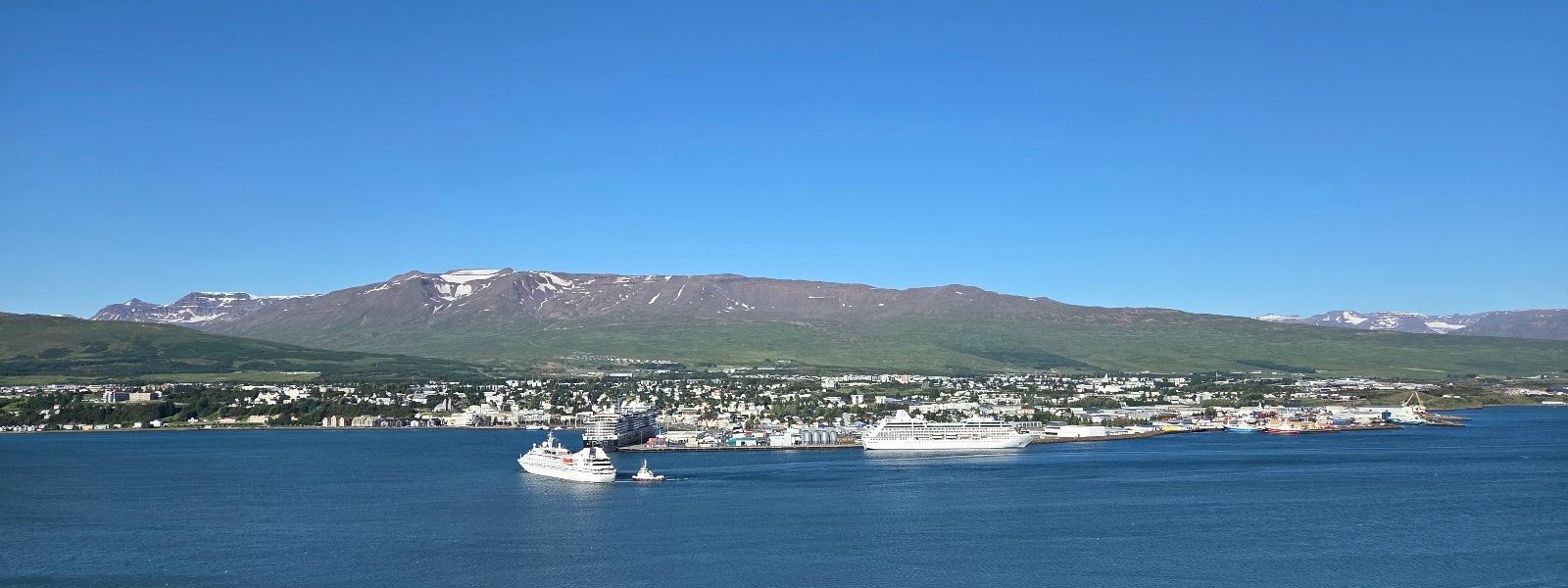
In July the panorama over Akureyri still reads at midnight — the town lies less than 100 km from the Arctic Circle.
- Accessibility
- Wheelchair-accessible parking and a step-free entrance.
- Parking
- Parking beside the road at the viewpoint. Two further car parks are mapped nearby: an asphalt one about 390 m away and a free one about 670 m away.
- Transport
- No bus stop at the viewpoint. The nearest mapped stops are Tangabryggja, about 1.2 km away, and Oddeyrarbryggja, about 1.3 km.
- Hours
- Open 24 hours.
- Address
- Route 1 over Vaðlaheiði, 606 Akureyri
What makes it special
The whole of Akureyri fits into one frame from here: the town at the head of Eyjafjörður, the harbour, the Oddeyri spit and the mountains behind. This is a stop rather than a destination. You park, look, photograph and drive on.
The view works twice over. By day it is roofs, ships and the calm water of Pollurinn in front of the town. In July it still reads around midnight, because Akureyri lies less than 100 km from the Arctic Circle and the light barely goes.
Good to know
- No facilities — there are no toilets and no drinking water at the viewpoint.
- Easy to miss in the dark — the pull-in is hard to spot at night. Set navigation before you drive up.
- Winter — snow cover around Akureyri forms in late October and lasts into April.
- A stop, not a stay — the view is the whole visit. Nothing else is laid on here.
Getting there
The viewpoint sits beside the road, and the view opens straight from the parking area. There is nothing to walk in. An information board stands at the stop itself. By day the pull-in is obvious from the road; in the dark it is easy to drive straight past, so set navigation before the last stretch.
Best time to visit
Best: June and July, in daylight or around midnight — the light holds through the night this far north.
Avoid: November to February, when Akureyri gets barely any sunshine.
Everything here depends on the weather, and this is a cloudy town: Akureyri averages 1,029 sunshine hours a year. Rain is another matter. Precipitation is far lower than in southern Iceland, as little as a fifth of what falls on Vík í Mýrdal.
Sun & daylight
Nearby Places



Similar Places



Your whole travel map in one place
Get inspired by new places around the world and find the ones worth the journey
Frequently asked questions
What can you see from Akureyri View Point?
Akureyri and the head of Eyjafjörður in one panorama: the town on the west side of the fjord, its harbour, the Oddeyri spit and the mountains around the water.Is it worth stopping after dark?
The view works by day and by night. In July it still reads around midnight, when the light barely goes. In the dark months the town shows as a field of lights.Are there toilets or drinking water?
No. Neither is mapped at the viewpoint or within 5 km of it. Plan to use facilities in Akureyri.How easy is the turn-off to find?
By day the stop is easy to see from the road. At night it is easy to drive straight past, so use navigation.