Bjarnarfoss is a waterfall on the south side of the Snæfellsnes peninsula in western Iceland, in the municipality of Snæfellsbær. It falls down the cliff wall that divides the moorland above from the coastal lowland. A path runs from the car park up to a bridge and viewing platform, and rougher trails carry on from there to the top. It is a common stop on the drive to Arnarstapi, and the basalt columns behind the water are the reason to walk up rather than look from below.
Bjarnarfoss Waterfall
Local name: Bjarnarfoss
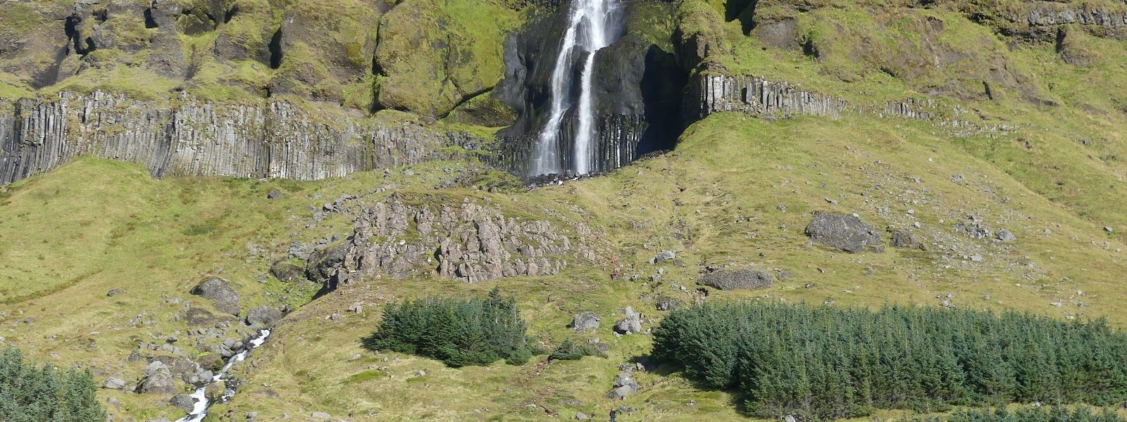
Get close enough to the water and you can see the basalt columns standing in the cliff behind it.
- Accessibility
- One visitor found the path from the car park to the viewing platform passable for people with limited mobility. Above the platform the ground is uneven.
- Parking
- Free. The nearest car park is 610 m from the fall, with a concrete surface.
- Difficulty
- Short but steep walk from the car park to the bridge and viewing platform, 15–20 minutes. Uneven trails continue to the top of the fall; the full route up and back takes about 45 minutes.
- Transport
- No bus stop within 5 km. Access is by car.
What makes it special
Most visitors reach the bridge and viewing platform and turn back from there. The reason to keep going is the rock. Get close to the falling water and you can see the basalt columns in the cliff behind it. Rough trails climb the right-hand side of the watercourse above the bridge, and from the end of the trail the fall is on one side and the coastal lowland and the sea on the other.
Bjarnarfoss is also quieter than the better-known stops on this coast, and quieter still above the platform, where few people go.
Good to know
- No facilities. There are no toilets, no drinking water and no information board within 5 km of the waterfall.
- Footwear. The climb from the car park to the bridge is steep. Hiking boots are worth having.
- Wind. The site is open and windy. Check the forecast before you plan to go above the bridge.
- The upper trails are uneven. Several rough paths run up the right-hand side of the watercourse. Go up only in settled weather.
Getting there
There is no bus stop within 5 km of Bjarnarfoss, so arrival is by car. From the car park a path climbs to a bridge and viewing platform below the fall. It is short but steep in places. That is as far as most people go, and it gives a clear view of the water. Beyond the bridge, uneven trails continue up the right-hand side of the watercourse towards the top of the fall.
Best time to visit
Better: early morning, before the first coaches.
Avoid: from 10 a.m. onwards.
Buses start arriving at 10 a.m., and before that the site can be almost empty. For photographs the weather counts for more than the hour. In flat grey light the coastline behind the fall disappears, and that coastline is most of the picture.
Sun & daylight
Nearby Places



Similar Places


Featured in our guides
Bjarnarfoss Waterfall on the map
Above the bridge the way up is a set of uneven trails on the right-hand side of the watercourse. The ground is steep and the site is exposed to the wind. In strong wind or rain, stop at the viewing platform and go no higher.
Get directions

Your whole travel map in one place
Get inspired by new places around the world and find the ones worth the journey
Frequently asked questions
Is Bjarnarfoss a quick stop or a proper walk?
Both work. Fifteen to twenty minutes covers the walk to the bridge and viewing platform. Carrying on to the top of the fall and back makes it a visit of about 45 minutes. It is a common stop on the drive to Arnarstapi.Are there toilets at the waterfall?
No. There are no toilets, no drinking water and no information board within 5 km. Plan your stops around that.Can you get close to the basalt columns?
Yes. Uneven trails run up the right-hand side of the watercourse from the bridge and viewing platform. They are steep and exposed, so go up only in good weather.How busy does it get?
Less busy than the better-known stops on Snæfellsnes. Buses begin arriving at 10 a.m. Most people turn back at the viewing platform, so the trail above it stays quiet even when the car park is not.