Borgarvirki is a volcanic plug in Northwest Iceland, 177 metres above sea level between Víðidalur and Vesturhóp. Its basalt columns form a natural ring. In earlier centuries people closed the gaps between them and turned the rock into a fortress, and the Icelandic sagas record it in military use. A wooden staircase leads inside and up to the top, where there is a viewing dial and a view over the surrounding valleys and out towards the Vatnsnes peninsula.
Borgarvirki Fortress
Local name: Borgarvirki
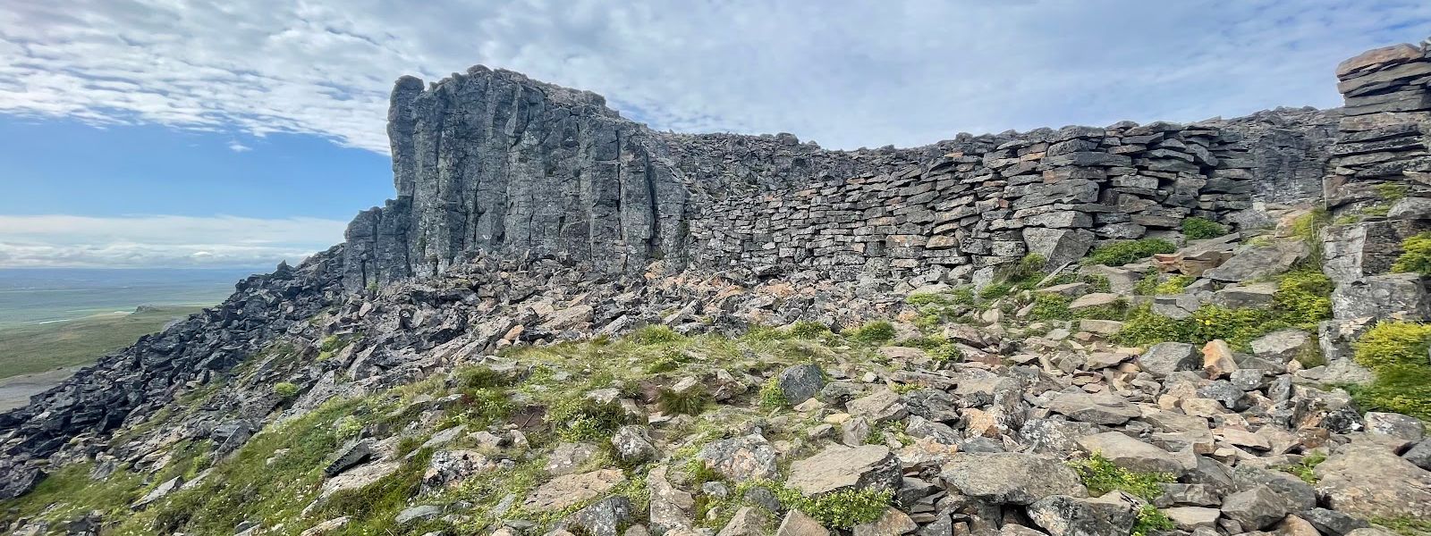
The walls are natural basalt columns. People only filled the gaps between them, and the Icelandic sagas record the result in use for war.
- Accessibility
- Not wheelchair accessible. The way up is a wooden staircase and then bare rock with no steps, and the descent is hard on stiff joints.
- Parking
- Parking area at the foot of the rock, at the end of an unpaved road.
- Difficulty
- A wooden staircase from the car park, then unstepped rock. Not an easy climb, and the path around the walls is unmarked.
- Address
- 531 Borgarvirki
What makes it special
Borgarvirki is a volcanic plug: a core of basalt left standing after the softer rock around it wore away. The result looks built. Ranks of basalt columns form a rough ring, and in earlier centuries people filled the gaps to turn the outcrop into a fortress. The Icelandic sagas record it in military use.
The site was renovated in 1949, when a granite lintel was set over the main entrance. A wooden staircase climbs from there into the interior. At the top there is a viewing dial and a 360-degree view over the valley and towards the Vatnsnes peninsula.
The route around the walls is not marked. You follow it by the slightly lighter colour of the rock where people have walked. There is an information board at the bottom; photograph it and read it as you go round, rather than reading it twice.
Good to know
- The road: the approach from Route 1 is unpaved and rocky, and not an easy drive.
- The climb: past the wooden staircase there are no steps. Coming back down over bare rock is the harder half.
- Route finding: the path around the walls is unmarked, and shows only as slightly lighter rock underfoot.
- Read first: photograph the information board at the bottom and read it as you walk through the fortress.
- Crowds: the site is off the main routes, and you may have the whole rock to yourself.
Getting there
Borgarvirki stands above the valley between Víðidalur and Vesturhóp, and is reached by travellers driving the Vatnsnes peninsula. The approach from Route 1 is unpaved and rocky, and it is not a comfortable drive. The road ends at a parking area below the rock. From there a wooden staircase takes you up through the main entrance into the fortress. Past that first flight the way is bare rock.
Sun & daylight
Nearby Places


Similar Places


Borgarvirki Fortress on the map
The only steps are the wooden staircase at the entrance. Above it the route runs over bare rock with nothing to hold on to, and the descent is the awkward part. Anyone with bad knees or ankles should stay below.
Get directions

Your whole travel map in one place
Get inspired by new places around the world and find the ones worth the journey
Frequently asked questions
What exactly is Borgarvirki?
A volcanic plug of basalt, 177 metres above sea level, between Víðidalur and Vesturhóp. Its columns form a natural ring that was built up into a fortress in earlier centuries. The Icelandic sagas mention it in military use.Can you drive to it?
Yes, to the foot of the rock. The approach from Route 1 is unpaved and rocky and not an easy drive, and it ends at a parking area. The climb up into the fortress is on foot.How hard is the climb?
Not easy. A wooden staircase gets you started, but there are no steps above it. The route round the walls is unmarked, and coming back down over bare rock is the awkward part.What can you see from the top?
A 360-degree view over the valley and out towards the Vatnsnes peninsula. There is a viewing dial at the top to name what you are looking at.Is it busy?
It sits off the main touring routes, and you may well have the site to yourself for the length of your visit.