Búlandstindur is a mountain in East Iceland, 1,069 metres (3,507 ft) above sea level, standing between the bays Berufjörður and Hamarsfjörður. It is a pyramid-shaped stack of basaltic strata, and the outline is unmistakable from the ring road. The villages around the mountain are known for fishing. For most travellers it is a photo stop on the drive along the east coast: there is no visitor infrastructure at the mountain itself.
Búlandstindur
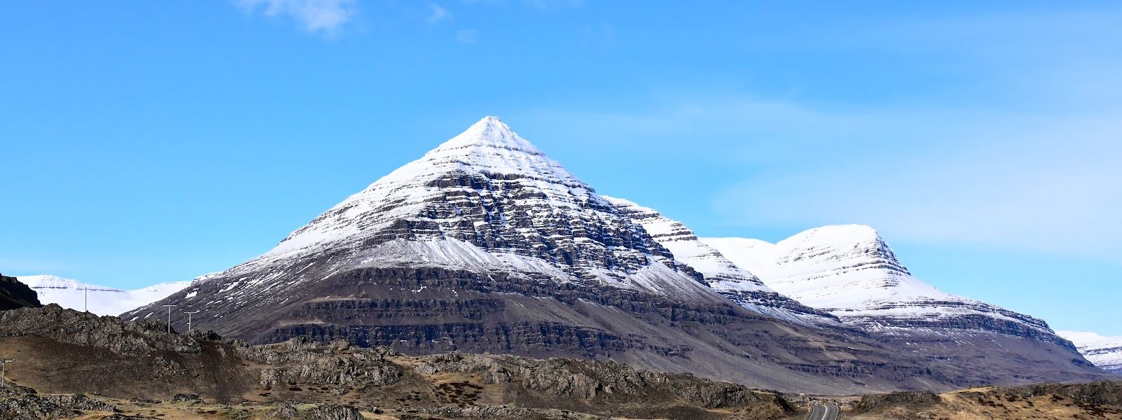
1,069 metres of horizontal basalt layers, stacked into a pyramid that the fishing villages below use as a landmark.
- Parking
- Two car parks are mapped about 4 km from the mountain, both free; one has a gravel surface.
- Transport
- No bus stop is mapped within 5 km of the mountain.
What makes it special
The shape is the reason people stop. Búlandstindur is a near-symmetrical pyramid built from horizontal basaltic strata, stacked flow on flow and then cut back by erosion. It rises 1,069 metres between the bays Berufjörður and Hamarsfjörður, and the outline shows from the ring road, which is where most photographs of it are taken.
The villages around the mountain live from fishing, and the mountain serves them as a landmark. Most travellers treat it the same way: a stop on the drive rather than a place to spend an afternoon. There is nothing at its foot but the view of it.
Good to know
- Facilities: No toilets, drinking water or information boards are mapped near the mountain.
- Cloud: Low cloud takes the summit first and flattens the pyramid outline. Check the mountain is clear before making a detour.
- Photos: The shape reads square-on from the road; from oblique angles the pyramid flattens into an ordinary ridge.
Getting there
Búlandstindur is a roadside sight first. The profile shows from the ring road along the east coast, and most people see it from the car. No bus stop is mapped within 5 km of the mountain, so arrival is by car. The two car parks mapped in the area lie about 4 km from the mountain, and the nearer of them is gravel.
Best time to visit
Better: clear weather, when the whole pyramid stands clear of the fjord walls behind it.
Avoid: low cloud. The summit goes first, and with it the shape that makes the mountain worth stopping for.
Búlandstindur is worth the stop for its outline and not for anything at its foot, so visibility decides the visit.
Sun & daylight
Nearby Places


Similar Places



Your whole travel map in one place
Get inspired by new places around the world and find the ones worth the journey
Frequently asked questions
How high is Búlandstindur?
1,069 metres (3,507 ft) above sea level.Why does it look like a pyramid?
It is a stack of basaltic strata — layer on layer of old lava flows, eroded back into a near-symmetrical triangular profile.Can you see it from the road?
Yes. The mountain stands between the bays Berufjörður and Hamarsfjörður and is visible from the ring road, where drivers stop for photographs.Is there public transport to the mountain?
No bus stop is mapped within 5 km of Búlandstindur. Arrival is by car.Are there toilets or a visitor centre?
No. No toilets, drinking water or information boards are mapped near the mountain.