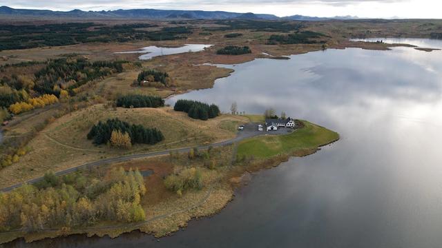
Graenavatn is a lake at Krýsuvík, on the Reykjanes peninsula in the Capital Region of Iceland. It fills a maar, a crater formed by steam explosions where rising magma met groundwater. The lake is one of a prehistoric maar complex inside the Krýsuvík volcanic system, which lies on the Mid-Atlantic Ridge. The water is green, and that colour is the reason people stop. The Seltún geothermal field is on the same road, Route 42, which runs on towards Kleifarvatn.
Graenavatn Lake
Local name: Grænavatn

The green water sits in a maar — a crater blasted open by steam when rising magma hit groundwater, one of a prehistoric cluster at Krýsuvík.
- Parking
- Free car park off Route 42, just over 200 m from the lake. No facilities.
- Difficulty
- The lake is in view from the car park. The crater rim is about 50 m further, along a signposted trail over the brow of the hill.
- Transport
- No bus stop nearby; the lake is reached by car.
- Hours
- Open 24 hours, every day.
What makes it special
The colour is the whole point. The green is strong and opaque in direct sun, and reads blue-green under cloud. Graenavatn fills a maar: a crater blown open by steam when rising magma reached groundwater. It is one of a prehistoric maar complex at Krýsuvík, inside the Krýsuvík volcanic system on the Mid-Atlantic Ridge.
From Route 42 you see the lake and nothing else. Walk about 50 m from the car park, over the brow of the hill, and the rim of a much larger crater opens up. Seltún, with its mudpots and sulphur-coloured ground, is on the same road, and the lake can be seen from the geothermal field.
Good to know
- No facilities. There are no toilets at the lake and none in the car park, and no drinking water.
- No clear signage. The lake is easy to drive past, and finding the spot takes some guesswork.
- The crater is hidden. From the road you see only the lake. The larger crater lies over the brow of the hill behind the car park.
- Pair it with Seltún. The geothermal field is on the same road, Route 42, and the lake is visible from it.
Getting there
Arrival is by car — there is no bus stop nearby. The car park sits on the left of Route 42 as you drive south, just over 200 m from the water. The lake is in plain view from there, so the stop works without walking at all. For the crater, take the hiking trail signposted in the car park and follow it about 50 m over the brow of the hill.
Best time to visit
Better: a clear, sunny day. Direct light is what brings the green out, and the lake is the only reason to stop here.
Avoid: rain and low cloud. There is no shelter and nothing to do but look at the water, and in flat light the colour goes grey.
The sky matters more than the hour. When it is overcast, spend the time at Seltún further along Route 42 instead.
Sun & daylight
Nearby Places



Similar Places




Your whole travel map in one place
Get inspired by new places around the world and find the ones worth the journey
Frequently asked questions
What is Graenavatn?
A lake in an explosion crater at Krýsuvík, on the Reykjanes peninsula. It is a maar, formed when rising magma met groundwater and blew the ground open with steam. It belongs to a prehistoric maar complex within the Krýsuvík volcanic system.Is there anything to see besides the lake?
Yes. A hiking trail is signposted in the car park. About 50 m along it, over the brow of the hill, you stand on the rim of a large crater that is not visible from the road.Can it be combined with the Seltún geothermal field?
Yes. Seltún lies next to Krýsuvík on the same road, Route 42, and the lake is visible from the geothermal field. Seltún has mudpots, fumaroles and hot springs, with ground stained yellow, red and green.Are there toilets at the lake?
No. There are no toilets and no drinking water, at the lake or in the car park.