Oxarfjordur – point of view is a viewpoint on the coast of Oxarfjordur, a broad fjord in northeastern Iceland between the Tjörnes and Melrakkaslétta headlands. Puffins breed on the cliffs below, and they are watched from the roadside rather than from a boat. Small waterfalls fall on either side of the viewpoint. The birds are ashore from mid-April to August; for the rest of the year the stop offers the fjord and its mountain ranges and nothing more.
Oxarfjordur – point of view
Local name: Öxarfjörður
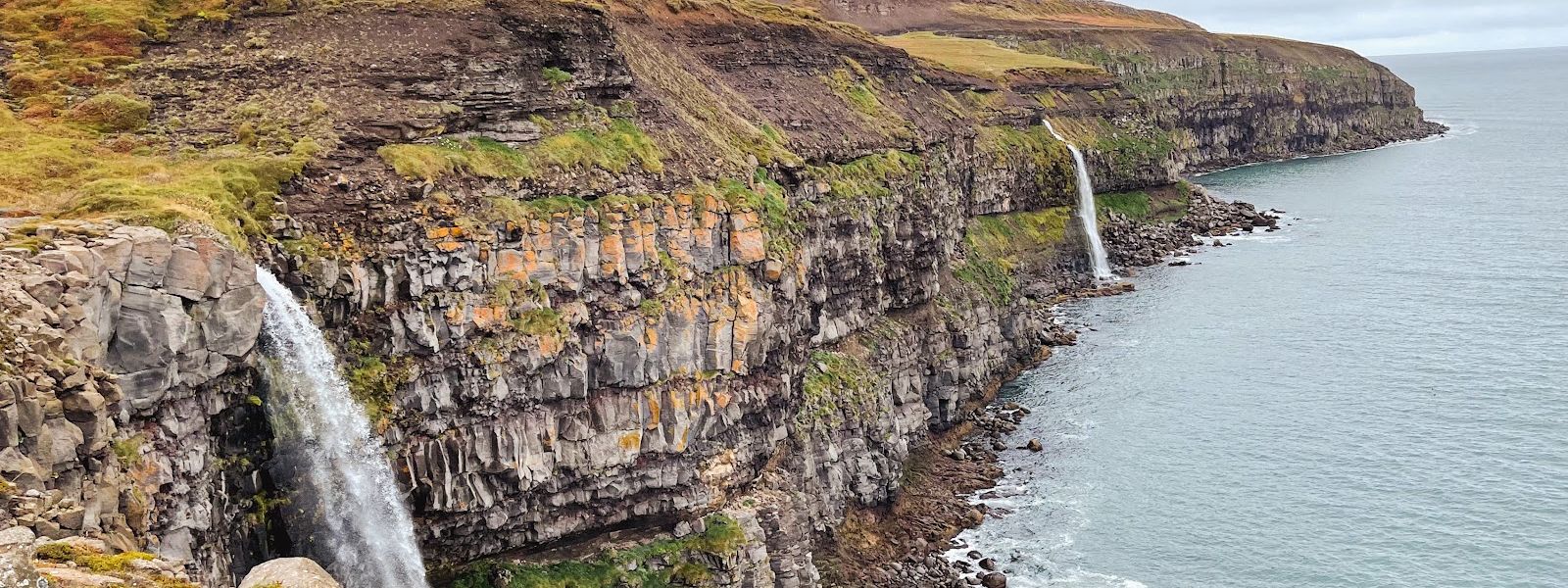
Puffins nest within sight of the road here — no boat trip, no hike, just a car park and a path along the edge.
- Accessibility
- The entrance is not wheelchair accessible.
- Parking
- Free car park at the viewpoint, and free parking on the roadside.
- Difficulty
- A couple of minutes on foot from the car park to the vantage points.
- Hours
- Open 24 hours.
- Address
- Route 85 (Tjörnes), 671 Iceland
What makes it special
Puffins are the reason to stop. They nest on the cliffs below the viewpoint, and you watch them from the roadside instead of from a boat. More than one vantage point runs along the edge, so it is worth moving along rather than shooting from the first spot you reach. The birds keep their distance. A 300 mm lens is the working minimum for a photograph worth keeping, and binoculars do more than a phone. Small waterfalls drop on either side of the viewpoint. Beyond them the fjord opens out, closed in by mountain ranges to the west and the east. The Mid-Atlantic Ridge crosses the western part of Oxarfjordur before it goes back under the sea.
Good to know
- Season: puffins are ashore from mid-April to August. Outside that window the cliffs are empty and the stop is a fjord view only.
- Bring a zoom lens: the birds sit well out, and 300 mm is the working minimum. A phone will not reach them; binoculars help.
- Distance: the puffins here stay further off than at some other Icelandic colonies. This is a place to watch them, not to stand among them.
- No toilets at the viewpoint. Sort that out before you turn off the road.
- Weather decides: the whole attraction is a long view, so low cloud or rain leaves nothing to do here.
Getting there
You get here by car, and the viewpoint is directly off the road: you park at it rather than near it. From the car park a path leads off to the left. That is the puffin side, and several vantage points follow along the edge above the water. No hike is involved and no boat — the whole visit happens within sight of the vehicle.
Best time to visit
Better: mid-April to August, in the morning.
Avoid: late August to mid-April, when the puffins are at sea.
The colony is the whole reason to stop, and it is here only for the breeding season. Mornings have been the productive hours: the cliffs busy at nine, and busy again at eleven. Clear weather counts as much as the hour, because this is a long view over the fjord and low cloud closes it down.
Things to do nearby
All tours in Northeast Iceland on GetYourGuide
Paid links: booking through them supports YowJourney.
Sun & daylight
Nearby Places


Similar Places



Your whole travel map in one place
Get inspired by new places around the world and find the ones worth the journey
Frequently asked questions
When can you see puffins at Oxarfjordur – point of view?
The birds are ashore to breed from mid-April to August. Visits from late April through early July have found them out in numbers, usually in the morning. Outside the breeding season there are no puffins on the cliffs.How close do the puffins come?
Not close. They are watched from the road at a distance, and they sit further out than at some other Icelandic puffin sites. For photographs, 300 mm is the minimum focal length; for watching, binoculars are enough.Is there anything to see besides the birds?
Yes. Small waterfalls fall on either side of the viewpoint, and the fjord itself opens out below, closed in by mountain ranges to the west and east. The Mid-Atlantic Ridge runs through the western part of the fjord.What else is worth seeing in the same area?
Jökulsárgljúfur, now part of Vatnajökull National Park, lies in the same district: Ásbyrgi, the horseshoe-shaped depression with the main campsite, the Hljóðaklettar echo rocks with their basalt columns, and Dettifoss, Europe's most powerful waterfall at a mean flow of 193 m³ per second.