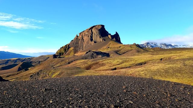
Stórasúla is a mountain peak in the Fjallabak highlands, in the interior of South Iceland. It is a steep, freestanding cone of palagonite tuff, rock built up by eruptions beneath ice-age glaciers. The name means the great pillar, and the shape explains it. Snow lies in its gullies well into summer. For most travellers Stórasúla is a landmark on the highland skyline rather than a destination in itself.
Storasula

Súla means pillar in Icelandic: the mountain is a single steep cone of volcanic tuff, set apart from every ridge around it.
- Entrance
- Free
- Difficulty
- A trailside landmark; the summit is a steep, unmarked scramble
- Transport
- On foot — on the Laugavegur trail, near the Hvanngil hut (highland, summer)
What makes it special
The shape registers first. Stórasúla is a near-symmetrical cone, standing clear of the ridges around it. From a distance it reads as a single form on the skyline. The rock is dark brown and loose, and rain has cut deep gullies into it. In summer green moss covers the lower slopes and the upper cone stays bare. The line between them is sharp. Afternoon light comes from the west and picks out the gullies, and that is when the cone looks steepest. Cloud settles on the summit often, and the mountain can stay hidden for a whole day. Álftavatn lies to the north, and from there Stórasúla is the dominant form on the horizon.
Good to know
- You reach it on the Laugavegur trail; the nearby Hvanngil hut is a common overnight or rest stop.
- This is summer-only highland — expect exposure, wind and unbridged stream crossings.
- Treat the peak as a viewpoint: the slopes are steep and there's no marked route up.
- Carry proper gear and check highland forecasts; conditions change fast this far inland.
Sun & daylight
Nearby Places



Similar Places

Storasula on the map
This is a remote highland landmark on the Laugavegur route — the trail has unbridged rivers and fast-changing weather; hike only in summer, well prepared, and don't take on the trackless summit lightly.
Get directions

Your whole travel map in one place
Get inspired by new places around the world and find the ones worth the journey
Frequently asked questions
Do I have to hike all of Laugavegur to see Stórasúla?
No. It sits beside the Álftavatn–Emstrur section, with the Hvanngil hut at its foot, so anyone walking or staying on that stretch passes it. In summer you can also reach that part of the trail on a day trip.Can I climb to the summit?
It's a steep volcanic cone with no marked trail up, so most people only view it from the route. A summit attempt suits experienced, well-equipped hikers who are comfortable on pathless, exposed highland terrain.Why is it green when everything around is black?
Centuries of moss and vegetation have covered the old cone. It stands out against the black volcanic sands of Mælifellssandur that begin just to its south — one of the Laugavegur trail's most dramatic colour contrasts.