Sveinstindar Peaks is a mountain in the South Iceland highlands, above the lake Langisjór. A track runs to its foot, and the climb from there to the summit is short and easy. The view is the reason to make the drive: Langisjór along its whole length, the Tungná and Skaftá springs, the Laki area, and, when the air is clear, Hekla and Vatnajökull. The climb takes less out of the day than the approach by road.
Sveinstindar Peaks
Local name: Sveinstindur
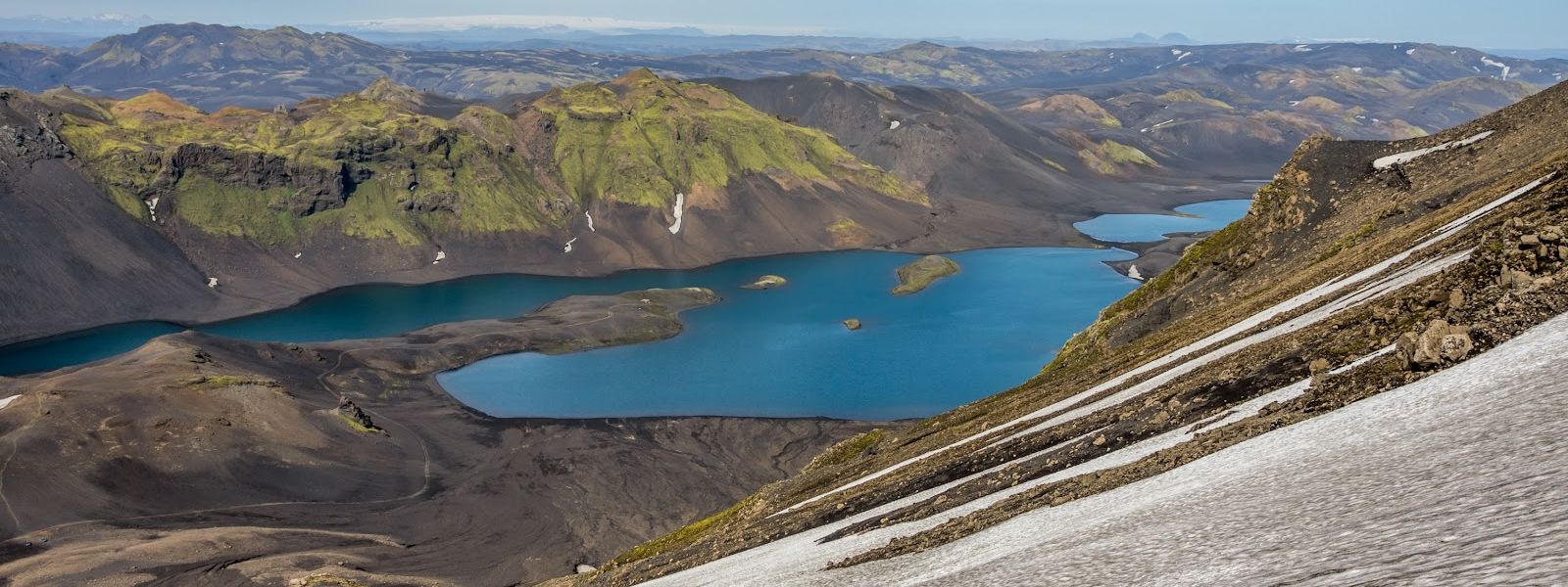
From one summit in clear air: Langisjór below, the Laki area, Hekla and Vatnajökull all at once — after a climb that costs less effort than the drive to its foot.
- Parking
- Small unpaved car park at the foot of the mountain, marked with stonework, under a kilometre from the peak. A second parking area 1.3 km away is closed to public access.
- Difficulty
- Short, easy climb on foot from the car park at the foot of the mountain to the summit.
- Address
- Sveinstindur, F235 (Langisjórsvegur), 881
What makes it special
The view from the top is the reason to come. Langisjór lies below, long and narrow. The Tungná and Skaftá springs and the Laki area are visible from the same summit, and in good visibility so are Hekla and Vatnajökull.
The climb itself is short and easy. A track runs to the foot of the mountain, and the walk begins where the vehicle stops, so the height is gained without a long approach on foot.
Visibility decides everything here. On a clear day the view runs a long way in every direction. In low cloud the summit shows nothing at all.
Good to know
- Visibility makes or breaks the trip. Hekla and Vatnajökull appear only in good visibility. In low cloud the summit shows nothing.
- Choose the road in. Route 235 is the shortest way and a dull drive. The approach that follows the Skaftá is better.
- The lakeside track needs a large 4x4. Maps show a track running along Langisjór below the mountain. Smaller vehicles should not attempt it.
- Drone spots are further along the lake, not at the summit itself.
Getting there
The last stretch is driven, not walked. A track leaves the road and runs to the foot of the mountain, ending at a small car park under a kilometre below the peak. The climb to the summit starts there, and it is short and easy. Plan the day around the drive rather than the walk: getting to the foot of the mountain takes far longer than getting to the top of it.
Best time to visit
Better: a clear day with good visibility.
Avoid: low cloud and haze.
The panorama is the whole point of the climb. Hekla and Vatnajökull come into view only when the air is clear, and under cloud the summit gives nothing back for the drive. Check the visibility before committing to the approach, not after arriving at the car park.
Sun & daylight
Nearby Places

Similar Places



Your whole travel map in one place
Get inspired by new places around the world and find the ones worth the journey
Frequently asked questions
How hard is the climb to the summit?
Short and easy. A track takes you to the foot of the mountain, and the walk to the top starts from the car park there.What can you see from the top?
Langisjór, the Tungná and Skaftá springs and the Laki area. In good visibility Hekla and Vatnajökull are visible as well.Can you drive to the bottom of the mountain?
Yes. A track runs to the foot and ends at a small unpaved car park marked with stonework, under a kilometre from the peak.Which road is the better approach?
The approach that follows the Skaftá is the more rewarding drive. Route 235 is shorter but monotonous.Is the track along Langisjór drivable?
It is shown on maps below the mountain, and it calls for a large 4x4. Ordinary vehicles have no business on it.