Budara Hiking Trail is a walking route in Reyðarfjörður, a fjord town in East Iceland. It follows a stream uphill out of the town, past the wartime museum, to a waterfall about 3.5 km there and back. The upper part runs on a service road and climbs more steeply. A footbridge crosses the river above the falls, and the top of the route gives panoramic views. The trail is also used at night for watching the northern lights.
Budara Hiking Trail
Local name: Búðarárstígur

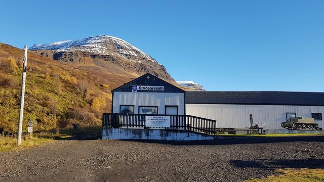
The route to the waterfall runs behind the houses of Reyðarfjörður and straight past the town's wartime museum.
- Entrance
- Free, no ticket.
- Accessibility
- No wheelchair access at the entrance.
- Parking
- Free asphalt car park about 100 m from the start. A second car park closer in is private.
- Difficulty
- About 3.5 km there and back, roughly 45 minutes of walking. Gradual uphill along the river, then a steeper climb on a service road.
- Transport
- Bus stop Reyðarfjörður - Molinn, about 100 m from the trailhead.
- Hours
- Open 24 hours, every day.
- Address
- 730 Reyðarfjörður
What makes it special
The whole walk is built around one stream and ends at its waterfall. From the start the path climbs alongside the water, behind a row of houses and past the wartime museum. Higher up it joins a service road and the gradient picks up. The waterfall comes into view from below, and the path carries on above it to a footbridge across the river. The top of the route opens onto panoramic views. It is a quiet trail rather than a busy one, and it is also used at night for watching the northern lights.
Good to know
- No facilities on the route. There are no toilets and no drinking water along the trail. Bring water with you.
- Do not turn left at the big bridge. That is a separate trail. Keep climbing, and the path to the waterfall runs behind the wartime museum.
- The climb steepens near the top. The riverside section is gradual, then the trail joins a service road for the last uphill stretch.
- The waterfall is not the end. A footbridge crosses the river above the falls, and the path continues up to it.
Getting there
The trail starts in Reyðarfjörður, and there is no long approach to it: a car park and a bus stop both stand within about 100 m of the start. Everything from there is on foot. The path follows the stream uphill, running behind a neighbourhood and past the wartime museum, then joins a service road for the steeper climb to the waterfall.
Best time to visit
Best: clear, dark evenings, when the trail is used for watching the northern lights, or full daylight if the waterfall is the point of the walk.
Avoid: starting the climb as the light goes. The falls and the panoramic views are both at the top of the route, and the last stretch is the steep one.
Sun & daylight
Nearby Places


Similar Places



Your whole travel map in one place
Get inspired by new places around the world and find the ones worth the journey
Frequently asked questions
How long is the walk?
About 3.5 km there and back, and roughly 45 minutes of walking with stops for photographs.What is at the top of the trail?
A waterfall. The path continues above it to a footbridge across the river, and the top of the route gives panoramic views.Where do people take the wrong turn?
At the junction with the big bridge. Do not turn left there. Keep going uphill; the trail to the waterfall passes behind the wartime museum.Are there toilets on the trail?
No. There are no toilets and no drinking water anywhere on the route.