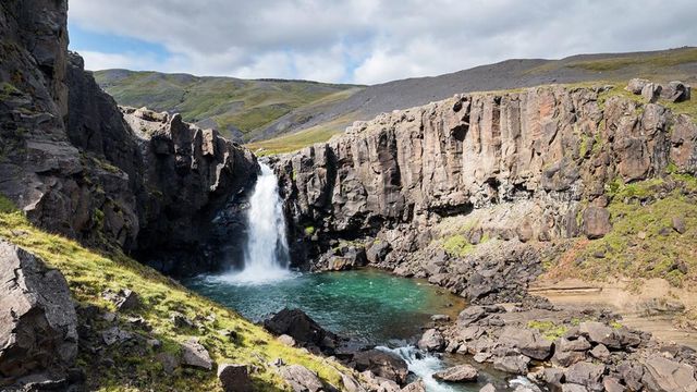
Litlanesfoss is a waterfall on the Hengifossá river in Fljótsdalur, East Iceland. It drops about 30 metres and spreads into an apron across the cliff, which is made of unusually high and regular basalt columns. Its second name, Stuðlabergsfoss, comes from that rock. The waterfall lies roughly midway along the uphill trail that runs from the car park to Hengifoss, so it is normally seen as part of that walk rather than on its own. The climb from the car park takes 15 to 30 minutes.
Litlanesfoss Waterfall
Local name: Litlanesfoss

A 30-metre fall inside a wall of straight hexagonal basalt columns — and it is only the halfway point of the trail to Hengifoss.
- Entrance
- Free
- Accessibility
- Not wheelchair accessible. The waterfall is reached only by an uphill hiking path, steep in places.
- Parking
- Car park at the start of the trail, charged — around 1,000 ISK. Toilets on site.
- Difficulty
- Uphill hiking path from the car park, steep in places but marked; 15–30 minutes' climb to the waterfall.
- Transport
- Self-drive — any car reaches the Hengifoss car park
- Hours
- Open at any time, every day.
- Address
- Upphéraðsvegur, 701
What makes it special
The rock is the draw here as much as the water. Litlanesfoss falls about 30 metres inside a cliff built of high, straight basalt columns, many of them hexagonal and set in unusually regular rows. The water spreads into an apron across that face. The waterfall sits on the Hengifossá river and appears roughly halfway up the trail that leads to Hengifoss, so most people meet it on the way to somewhere else. A smaller waterfall comes first, lower down the path. Behind you the Fljótsdalur valley opens out, and the view back down the slope is worth as much as the fall itself.
Good to know
- Toilets are at the car park. They sit at the start of the trail, and there are none higher up.
- The path climbs the whole way. It is steep in places, and marked throughout.
- In winter the trail is snow and ice. Wind on the open slope makes the climb harder, and snow covers the columns.
- No wheelchair access. The waterfall is reached only by the hiking path, and there is no step-free route.
- Litlanesfoss is not the end of the trail. The same path carries on uphill to Hengifoss, and many walkers do both.
Getting there
Drive to the car park at the foot of the Hengifoss trail, in Fljótsdalur in East Iceland. Everything after that is on foot. The path climbs from the car park to Litlanesfoss in 15 to 30 minutes, steep in places but marked the whole way. A smaller waterfall passes on the left of the climb before Litlanesfoss comes into view. Walkers who continue to Hengifoss carry on up the same path.
Best time to visit
Better: summer and early autumn, when the path is clear and the columns and the valley are both visible.
Avoid: winter and early spring, when snow and ice cover the trail.
The basalt is the point of the visit, and snow hides it — in late March the climb is iced over and the view flattens out. Wind on the open slope adds to the work in the cold months. In September sheep graze the hillside beside the path.
Sun & daylight
Nearby Places



Similar Places


Featured in our guides
Litlanesfoss Waterfall on the map
In winter and early spring the trail is covered in snow and ice, and the steep sections are the hazard. Wind on the open slope makes the climb hard work in the cold months.
Get directions

Your whole travel map in one place
Get inspired by new places around the world and find the ones worth the journey
Frequently asked questions
How high is Litlanesfoss?
About 30 metres. The water spreads into an apron across the cliff face rather than falling in a single jet.How long is the walk from the car park?
The climb to Litlanesfoss takes 15 to 30 minutes. The path is steep in places and marked throughout.Can you see more than one waterfall on this walk?
Yes. A smaller waterfall comes first on the way up, and the same trail continues past Litlanesfoss to Hengifoss.Is the trail suitable for wheelchairs?
No. The only approach is an uphill hiking path, steep in places, with no step-free route.Is it worth coming in winter?
The basalt columns disappear under snow and ice, and wind makes the climb harder. The walk is doable, but the view is much reduced.