Dynkur, also known as Búðarhálsfoss, is a waterfall on the Þjórsá river in the highlands of South Iceland. The river spreads over a step of rock and falls in many separate strands rather than a single sheet. It lies off the main routes: the way in is a private road kept up by local farmers and passable only by 4x4, followed by about a 40-minute walk on marker poles. That keeps the numbers down, and most people who get here have the falls to themselves.
Dynkur Waterfall
Local name: Dynkur (Búðarhálsfoss)
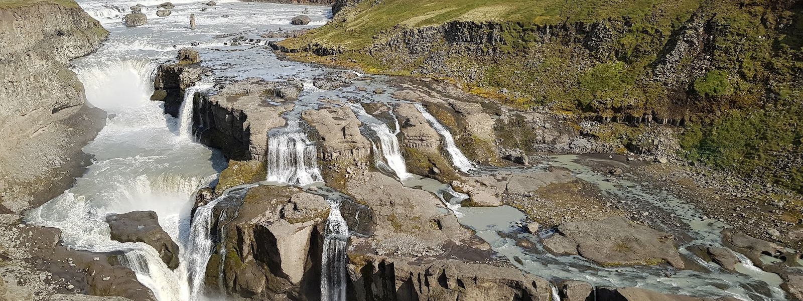
The only way in is a private farm track that takes a 4x4, which is why a waterfall this size is usually deserted.
- Entrance
- Free
- Accessibility
- Not wheelchair accessible: no accessible entrance, and the approach from the parking is on foot along marker poles.
- Parking
- Parking area at the end of the private access track.
- Difficulty
- About 40 minutes on foot from the parking area, following marker poles rather than a made path.
- Transport
- No public transport. Access is by 4x4 on a private farm road, or on a guided super-jeep trip.
- Hours
- Open 24 hours; no set visiting times.
What makes it special
Dynkur is not one drop. The Þjórsá spreads across a step of rock and comes down in separate strands, white water on dark basalt, and the sound reaches you before the whole falls are in view. The name is the Icelandic word for a heavy rumbling thud. Glacial silt keeps the river grey-brown, and it never runs clear.
The other half of the place is the emptiness. The road in is private, kept up by local farmers, and the last stretch is on foot. Hardly anyone makes the trip, so the falls are usually deserted.
Good to know
- No 4x4? Guided super-jeep trips run to Dynkur, and that is the usual way in for visitors driving an ordinary hire car.
- You will be alone. The falls are usually deserted, so there is nobody to help if something goes wrong. Carry water, food and warm layers.
- Two names. The waterfall appears as both Dynkur and Búðarhálsfoss, so search either one in a map app.
Getting there
The last leg is a private road, maintained by local farmers, and it takes a 4x4 — an ordinary hire car will not get down it. The track ends at a parking area, and from there the falls are about 40 minutes on foot, marked by a line of poles rather than by a built path. Visitors without a suitable vehicle come on guided super-jeep trips.
Best time to visit
Better: a clear day, with enough daylight left for the drive in and the walk both ways.
Avoid: setting off in low cloud or fading light.
Crowds are not the problem here. The access road keeps almost everyone away, and you will probably have the falls to yourself. Visibility is the problem. The route from the parking is a line of marker poles rather than a built path, and poles are easy to lose when the cloud comes down.
Sun & daylight
Nearby Places


Similar Places


Dynkur Waterfall on the map
The track in is a rough 4x4-only F-road with river fords that rise fast in rain or thaw — drive it only in summer, and turn back if a crossing runs deep or fast. At the falls, stay back from the wet, unfenced rock at the canyon edge.
Get directions

Your whole travel map in one place
Get inspired by new places around the world and find the ones worth the journey
Frequently asked questions
Can you drive to Dynkur in an ordinary car?
No. The road in is private, maintained by local farmers, and passable only by 4x4. Without one, the way to see the falls is a guided super-jeep trip.How long is the walk from the parking?
About 40 minutes on foot, following marker poles rather than a made path. Allow the same again for the way back.Is Dynkur busy?
No. The 4x4-only access keeps numbers very low, and the falls are usually deserted.Can you visit at any hour?
The site is open 24 hours. In practice the limit is daylight and the drive in, not opening times.Is Dynkur suitable for wheelchair users?
No. There is no wheelchair-accessible entrance, and the falls are reached on foot from the parking area along marker poles.