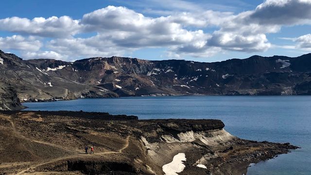
Hraunsvatn is a mountain lake in Northeast Iceland. It is reached on foot: an 8 km hike with a steep, rocky climb, and no sight of the water until the top. The lake lies in a basin below mountains and bare rock formations, and the flat shore is used for picnics. Nothing is built here. Most people come in summer — the lake freezes over in winter, and midges are troublesome by the water in warm weather.
Hraunsvatn Lake
Local name: Hraunsvatn

You see nothing of the lake for the whole walk in — it opens out at once when the climb ends, with mountains standing behind it.
- Entrance
- Free. There is no ticket, and the route past the house is walked through.
- Accessibility
- Not suitable for wheelchairs or pushchairs: the only way in is a steep, rocky climb.
- Parking
- At the trailhead farm (Nýjibær)
- Difficulty
- Demanding. The hike is 8 km, with a steep climb of about a mile after the house.
- Transport
- Self-drive (Ring Road through Öxnadalur), then hike
What makes it special
The lake stays hidden almost to the end. The route climbs over rough, rocky ground, and Hraunsvatn appears only once the steep section is behind you. It sits in a basin, with mountains and bare rock formations standing behind the far shore. The ground by the water is flat and open, and the shore is where people stop to eat. For a lake this size, the approach does most of the work: 8 km of walking, and the view arrives all at once.
Good to know
- No facilities: there are no changing rooms and nothing to buy at the lake. Carry water and food.
- Underfoot: parts of the path are overgrown, and loose rock is scattered across the climb. Wear boots, not trainers.
- Insects: midges are thick by the water in warm weather. Bring repellent.
- Winter: the lake freezes over. This is a summer walk.
Getting there
The lake is reached on foot. The walk starts past a house and feels at first like crossing someone's yard; walkers do go through. After the house the route turns right and starts climbing, and the steep part is about a mile of rocky ground. The whole hike is 8 km, and nothing on the way in shows you the lake.
Best time to visit
Better: summer, when the lake is open water rather than ice and the shore is worth the stop.
Avoid: midwinter, when the lake freezes over.
Warm weather brings midges to the water in numbers, so carry repellent along with the picnic.
Sun & daylight
Nearby Places



Similar Places


Hraunsvatn Lake on the map
The route to Hraunsvatn is a real mountain hike with steep, exposed sections and fast-changing weather; only parts are pole-marked, so navigation is on you in cloud. Go only in summer with proper boots and layers, and turn back if visibility drops — the Hraundrangi spire itself is for equipped climbers only.
Get directions

Your whole travel map in one place
Get inspired by new places around the world and find the ones worth the journey
Frequently asked questions
Does the walk cross private land?
The start passes close to a house and looks like private ground. Walkers do go through: after the house the route turns right and climbs.Can you swim at Hraunsvatn?
There is nothing set up for bathing here — no changing rooms and no heated water. In winter the lake freezes over.Is there anything at the lake?
Nothing built. The flat shore is used for picnics, so bring food, water and repellent: midges are bad by the water in warm weather.What is the ground like?
Rocky. Loose stone lies across the climb, and parts of the route are overgrown.