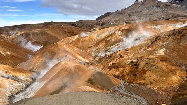
Hveradalir is a geothermal valley in the Kerlingarfjöll range, in the highlands of South Iceland. Steam rises from vents across the slopes, mud pools bubble beside the paths, and the rhyolite hills around them carry strong ochre and rust colouring, with snow on the peaks above. A marked loop with boardwalk sections leads through the hottest ground and takes about an hour and a half. The valley is remote: the approach is rough gravel road, a 4WD is needed, and no toilets or drinking water are mapped nearby.
Hveradalir

Hot water pushes up through mud and sand on the valley floor while snow still lies on the peaks around it.
- Accessibility
- Not suitable for wheelchairs or prams. The route crosses gravel, rock and old snow, with boardwalk sections and a stretch along a cliff edge.
- Parking
- Free car park about 1.5 km from the valley; a second car park about 2 km out.
- Difficulty
- Moderate. A loop of roughly an hour and a half over gravel, rock, snow and dirt, with a little scrambling; the paths are slippery from geothermal moisture.
- Transport
- No public transport: no bus stop is mapped within 5 km. Access is by car.
- Address
- Hveradalir, 846, Iceland
What makes it special
The ground at Hveradalir is still working. Steam rises from vents in the slopes, and mud pools bubble close to the path. The hills are rhyolite, so the colour runs from ochre to rust to pale grey, with snow on the peaks behind them. Boardwalks carry the route over the hottest ground. The walking changes constantly: gravel, bare rock, old snow and wet dirt inside a single loop. The sulphur smell is strong in some pockets and gone a few steps later. Allow more time than the distance suggests. Moving from one viewpoint to the next eats an hour or two without any effort.
Good to know
- Driving in: the approach is bumpy gravel road and its state depends on the weather. A 4WD is needed.
- Weather: wind, cold and sudden changes are normal here, summer included. Bring a windproof jacket.
- Footing: geothermal moisture keeps parts of the path slippery. Wear hiking boots with grip; poles help.
- No facilities: no toilets, drinking water or information point is mapped within 5 km of the valley.
- Stay on the marked trails and boardwalks: the terrain is fragile and the ground under it is hot.
Getting there
There is no bus. Visitors drive in, and the last stretch is long, bumpy gravel that calls for a 4WD. The nearest mapped car park sits about 1.5 km from the valley and is free; a second lies about 2 km out. From there you walk. One route in starts at the hotel in Kerlingarfjöll, and the ground underfoot changes from gravel to rock to old snow before the boardwalks begin.
Best time to visit
Better: a clear day in summer.
Avoid: low cloud, rain and strong wind.
Colour is the whole point here. In sun the rhyolite reads ochre, rust and grey-green; under cloud it flattens out and the steam is all that is left to look at. Rain also makes the mud and the boardwalks slick. Highland weather turns fast, in summer as well, so treat a good forecast as luck rather than a plan.
Sun & daylight
Nearby Places


Similar Places

Hveradalir on the map
The ground is geothermally active and the crust near vents and mud pools is fragile — keep to the marked trails and boardwalks. Geothermal moisture leaves parts of the path slippery, and one section of the loop runs along a cliff edge. Wind and cold arrive suddenly, in summer too.
Get directions

Your whole travel map in one place
Get inspired by new places around the world and find the ones worth the journey
Frequently asked questions
Do you need a 4WD to reach Hveradalir?
Yes. The road in is long, bumpy gravel, and how rough it is depends on the weather and road conditions.How long does the walk take?
One visitor walked the loop in an hour and a half at an unhurried pace. Allow longer if you stop at viewpoints, which is easy to do.Are there toilets or drinking water?
None is mapped within 5 km of the valley, and there is no information point either. Deal with that before you drive in.Can you get there by public transport?
No. No bus stop is mapped within 5 km. Access is by car.What should you wear?
Hiking boots with grip, warm layers and a windproof jacket. The paths are muddy and slippery, and poles help on the loose ground.