Bunarfoss is a cascading waterfall on a stream north of the Tungudalur campsite, near Ísafjörður in the Westfjords of Iceland. A trail climbs from a small car park below the falls and follows the stream to the top, passing several viewpoints. Most of the climb is easy to moderate, with a few steep sections. It is a walk people do from the campsite or from Ísafjörður itself.
Bunarfoss Waterfall
Local name: Bunárfoss

The path passes a run of small cascades before the main falls, and there is a pool at the top that people swim in.
- Parking
- Small free car park by the trailhead, about 400 m from the falls; one of the two areas is asphalt.
- Difficulty
- About 1.3 miles out and back to the top, steadily uphill. Easy to moderate for most of its length, with a few short steep climbs where fixed ropes are in place.
- Transport
- Nearest bus stops are Tungudalur and Tunga, both about 1.5 km from the falls.
- Hours
- Open 24 hours.
- Address
- Tungudalur, Ísafjörður, 400
What makes it special
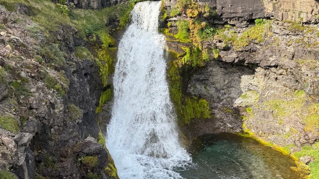
The stream comes down in a series of cascades, and the walk takes them in order: small falls first, then the main drop near the top. There is a pool at the head of the big fall, and people swim in it. Trails run up both banks, so the falls can be seen from below and from above. From the top there are views over the surrounding countryside. Bunarfoss is not in the same category as the famous Icelandic waterfalls. What it offers is a short climb with something at the end of it, close to Ísafjörður and right above the Tungudalur campsite.
Good to know
- No facilities. There are no toilets or services at the trail. The WCs at the Tungudalur campsite are for campers only.
- Find the trailhead, not the waterfall. Map apps lead you to the start if you search for the Bunarfoss trailhead rather than the falls.
- Ropes on the steep parts. A few short pitches are steep enough that fixed ropes have been put in. The rest is easy to moderate walking.
- Longer route from town. Walking from Ísafjörður instead of driving makes it a hike of about 7 miles, the first 1.5 of them dull.
Getting there
Most people drive. There is a small car park just below the trailhead, north of the Tungudalur campsite, and the walking starts there. The path follows the stream uphill, with viewpoints on the way, and it is about 1.3 miles out and back to the top of the falls. Ísafjörður is close enough to set off from on foot, but that turns the day into a hike of roughly 7 miles.
Best time to visit
Better: a dry day. Avoid: the trail in rain.
Rain is the deciding factor here rather than the season. Wet rock on the steep pitches slows the climb badly, and that is the reason to postpone. Fixed ropes are in place on those sections, but they are a handhold, not a fix. Most of the rest of the route is easy to moderate walking.
Things to do nearby
All tours in Ísafjörður on GetYourGuide
Paid links: booking through them supports YowJourney.
Sun & daylight
Nearby Places


Similar Places


Featured in our guides
Bunarfoss Waterfall on the map
A few sections of the trail are steep and the rock there turns slick in rain. Fixed ropes are in place on those pitches.
Get directions

Your whole travel map in one place
Get inspired by new places around the world and find the ones worth the journey
Frequently asked questions
How long is the walk to the top of the falls?
About 1.3 miles out and back from the car park below the trailhead. It is a steady uphill walk with several viewpoints on the way.Can you walk there from Ísafjörður?
Yes, and it comes to about 7 miles in total. The first 1.5 miles are dull going before the trail proper starts at the stream.Can you see the falls from both sides?
Yes. Trails run up both banks of the stream to the top of the falls, which gives views from below and from above.Is it worth it if you have already seen the famous Icelandic waterfalls?
Bunarfoss is not in that category. It works as a walk with something at the end of it, particularly if you are staying at the Tungudalur campsite.