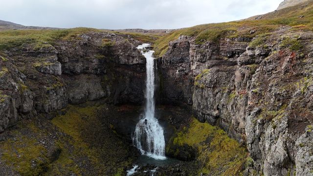
Godafoss is a waterfall in a rocky gorge in the Westfjords of northwest Iceland, near Bjarnarfjordur. A river runs through the canyon and drops over a step in the rock. It shares a name with the well-known Godafoss in North Iceland, but this is a different river and a different waterfall. Reaching the overlook takes a walk of 15 to 20 minutes along the south side of the gorge. The direct view of the falls is from the east side, across the water.
Godafoss (Bjarnarfjordur) Waterfall
Local name: Goðafoss (Bjarnarfjörður)

The waterfall only comes fully into view from the east side of the gorge, and there is no bridge — you cross the river by hopping between rocks above the falls.
- Entrance
- Free.
- Accessibility
- Not wheelchair accessible. The parking spot is not adapted, and the walk starts with wooden steps over a fence.
- Parking
- Free. A dirt road off the main road climbs for a minute to a parking spot close to the gorge; roadside parking is free as well.
- Difficulty
- Easy to moderate, 15–20 minutes on foot along the south side of the gorge; up to about 500 metres one way. Crossing the river to the east side is harder.
- Transport
- Self-drive (Route 643, Strandir)
- Hours
- Open around the clock, every day.
- Address
- Route 643, Bjarnarfjörður (Strandir)
What makes it special
The path follows the rim of the gorge, not the water. From the south side the view runs straight up the canyon, with the falls at the head of it. The full, face-on view is from the east side, and there is no bridge. The river is crossed at the top of the gorge, stepping from rock to rock above the drop, and that crossing is the hard part of the outing. Everything else is a walk on the rim. In autumn the blueberry heather on the slopes turns red, and the gorge is at its most colourful then. Wind is the constant here: the rim is open, and the higher you go along it, the stronger it blows.
Good to know
- Wind: the gorge rim is exposed and the top of the walk is the windiest part. Bring a windproof layer.
- No bridge: the east side is reached by stepping from rock to rock across the river at the top of the gorge.
- A fence on the way in: the walk begins with wooden steps built over a fence by the parking spot.
- Same name, different waterfall: the well-known Godafoss is in North Iceland. This one is in the Westfjords, near Bjarnarfjordur.
Getting there
Access is by car. A homemade Godafoss sign with an arrow stands by the road; take the next right after it, onto a dirt road that climbs for a minute to the parking spot. You can park close to the gorge. From there the walk keeps to the south side of the canyon and ends at an overlook facing straight up it. There are trails on the east side, but the way onto them is not obvious, and the river is crossed at the top of the gorge.
Best time to visit
Better: autumn, when the blueberry heather on the slopes above the gorge turns red.
Avoid: days with strong wind. The rim is exposed, and the top of the walk catches the worst of it.
Wind, rather than the hour of the day, decides how the visit goes. Dressed for it, the walk along the rim is straightforward; caught out by it, the last stretch to the overlook is unpleasant.
Sun & daylight
Nearby Places



Similar Places


Godafoss (Bjarnarfjordur) Waterfall on the map
The gorge is very windy, and the rim gives no shelter. The river crossing to the east side is made on loose rocks at the top of the gorge, upstream of the drop, with no bridge and no handrail. Do not attempt it in high water.
Get directions

Your whole travel map in one place
Get inspired by new places around the world and find the ones worth the journey
Frequently asked questions
Is this the same Godafoss as the one in North Iceland?
No. This Godafoss is in the Westfjords, near Bjarnarfjordur. The better-known waterfall of the same name is in the north of the country.How long is the walk to the waterfall?
15 to 20 minutes, easy to moderate, along the south side of the gorge. The stretch on towards the head of the falls runs up to about 500 metres one way.Do you have to cross the river?
Only for the direct view. The overlook on the south side looks straight up the canyon; the east side, reached by stepping across rocks at the top of the gorge, faces the falls.Are there trails on the east side?
There are, but the way onto them is not obvious. The usual approach is to cross the river at the top of the gorge and walk back down the far rim.