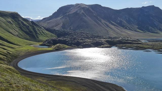
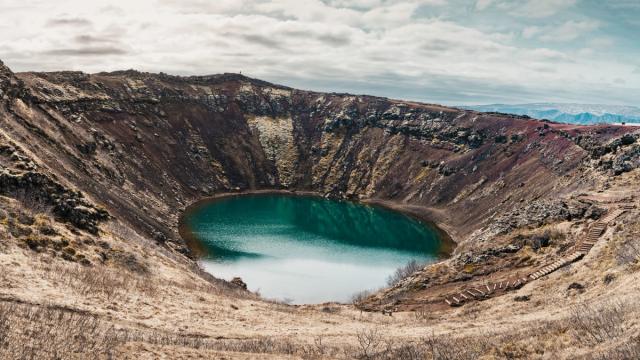
Ljotipollur is a crater lake in the highlands of South Iceland, at 722 m above sea level. It fills a maar, an explosion crater, and its steep red walls enclose water that is fished for trout. The track ends below the rim, and the lake is seen from the edge above; the descent to the shore is steep in both directions. Rugged volcanic peaks and plains surround the crater and are used for hiking.
Ljotipollur Crater
Local name: Ljótipollur

The name means "Ugly pond" in Icelandic, which the red crater walls and the water below them do nothing to justify.
- Entrance
- Free
- Accessibility
- No step-free access. The slope between the rim and the water is steep and unsurfaced.
- Parking
- Free; short walk to the rim
- Difficulty
- Two to five minutes on foot from the end of the track up to the rim. Steep descent to the shore and a steep climb back; walking poles are not needed.
- Transport
- 4x4 via F208 North/F225 (summer only)
- Advance booking
- Fishing requires a permit. It can be bought online.
- Address
- Ljótipollur, 851, Iceland
What makes it special
Ljotipollur is a maar — a crater blasted out by a steam explosion and later filled with water. The walls are red and bare, and they drop straight to the lake. From the rim the whole bowl is visible at once, with the volcanic peaks and plains of the highlands behind it. Trout live in the water, and the lake is fished. Getting down to the shore is the steep part, and the climb back out is steeper still. The view that most people come for is the one from the top edge.
Good to know
- The climb back: the way down to the water is steep, and the return is a climb. Allow more time for it than for the descent.
- Footwear: boots with grip are worth having on the slope. Walking poles are not necessary.
- Fishing: the lake holds trout, but catches vary and a good day is not guaranteed.
- Exposed rim: the crater lies at 722 m in the highlands. Wind on the rim is cold — bring a windproof layer.
Getting there
The last part of the approach is on foot. The track stops below the crater rim, and it is a two- to five-minute walk up to the edge. The lake itself is another matter. The inner wall is steep, and the way to the water goes straight down it. Coming back up is the work. Anyone who stays on the rim still gets the full view of the crater.
Sun & daylight
Nearby Places

Similar Places

Featured in our guides
Ljotipollur Crater on the map
The wall of the crater is steep from the rim down to the lake, and the climb back out is harder than the way down. Go down only if you are sure you can get back up.
Get directions

Your whole travel map in one place
Get inspired by new places around the world and find the ones worth the journey
Frequently asked questions
What does the name Ljotipollur mean?
Ugly pond, in Icelandic. The lake fills a maar — an explosion crater — with steep red walls.Can you fish at Ljotipollur?
Yes. The lake holds trout and is fished. Catches vary from day to day, and some visits end with almost nothing.How hard is it to get down to the lake?
The descent from the rim to the water is steep, and the climb back out is the harder half. Walking poles are not needed.What else is there to do around the crater?
Walking. Rugged volcanic peaks and plains surround the lake and are used for hiking.